_-_Church_of_Saint_Catherine,_aerial_view.jpg)
Hoogstraten
Look at a map of Belgium's northern edge and you will find a small bulge of Flanders pushing up into the Netherlands, almost surrounded on three sides by Dutch territory. That bulge is the old county of Hoogstraten, and at its heart stands a brick church whose tower has dominated this flat horizon since the 1500s. The streets feel Dutch, the accents lean Dutch, even fifteen percent of the people who live here are Dutch. But the postal codes start with 2 and the beer is poured Flemish-style, because here, against the geographic odds, the border holds.
The Road That Built the Town
Hoogstraten owes its existence and its name to a single straight line: the hoge straat, the high road that once connected Antwerp to 's-Hertogenbosch. It was a military highway, not a trade route. In the early Middle Ages little surplus moved between villages, and the travelers who passed through were mostly soldiers and supply trains. So Hoogstraten grew up as a string of thatched cottages along that road, with an inn for the soldiers, a stable for their horses, and a wide unpaved street called the Vrijheid where everything happened. There was no hill to climb to, no lake to gather around. The road was the town, and the town was the road. In 1210 Hoogstraten received its charter as a free town, an early legal privilege that gave it room to grow into something more than a wayside stop.
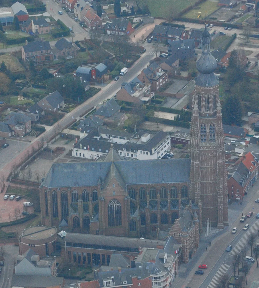
Brick That Outlasted Empires
By 1525 the wayside stop had ambitions. Count Antoon de Lalaing and his wife Elisabeth van Culemborg commissioned an enormous brick church, St. Catherine's, construction beginning on 18 November 1525, and a matching town hall next door in 1530. The church was consecrated in 1544, its bell tower rising in the same warm red brick that would become Hoogstraten's signature. Margaretha of Austria elevated the surrounding land to a county, and Emperor Charles VI later promoted Hoogstraten itself to a duchy in 1740. Brief glory: French rule a few decades later stripped away the titles of town and duchy, supposedly punishing local anti-French sentiment. Even the buildings suffered. But the brick survived. So did the tower, the town hall, and the slight hill behind them where the Counts' castle once stood, a kilometer from the church that still anchors the Vrijheid.
The Longest Mutiny
Not all of Hoogstraten's history involved counts and church bells. Between September 1602 and May 1604, during the Eighty Years' War, soldiers of the Spanish Army of Flanders staged the longest mutiny in that long, miserable conflict, refusing to fight until they were paid. They occupied Hoogstraten for twenty months. Two centuries later, in early 1814, the town again found itself caught in someone else's war, this time as the site of the Battle of Hoogstraten, where coalition forces drove out Napoleon's retreating troops. For a place built around an inn on a quiet stretch of road, Hoogstraten has hosted an outsize share of restless soldiers.
Thirty Thousand Tonnes of Strawberries
Today the soldiers are gone and the strawberries have arrived. Veiling Hoogstraten, the town's auction house, is one of the largest in the Benelux, trading more than thirty thousand tonnes of strawberries every year, though tomatoes are actually the main crop by volume. In February, when the fields are bare, cyclo-cross riders churn through the mud at the Vlaamse Aardbeiencross, the Flemish Strawberry Cross, a race so locally branded it might as well be sponsored by the harvest. The Beguinage founded in 1380 for poor elderly women still stands, restored, near the church. So does het Laermolen, a watermill on the River Mark already old when it was first written down in 1391.
An Almost-Dutch Belgian Town
Visitors arriving from Breda or Tilburg often do not realize they have crossed a border at all. The landscape stays flat, the brick keeps the same warm red, even the road signs use the same Dutch words. Then they see the price of beer drop, hear the softer southern Flemish vowels, and notice that the postal codes have shifted. Meersel-Dreef, one of the villages folded into the modern municipality, contains the northernmost point in Belgium, a quiet patch of farmland barely poking into Dutch territory. Hoogstraten lost and regained its formal town status more than once over the centuries. Since 1985 it has once again been entitled to call itself a stad, a small enclave keeping its Flemish identity inside a Dutch embrace.
From the Air
Coordinates 51.40 N, 4.76 E. Cruise at 4,000 to 6,000 feet for clear views of St. Catherine's brick tower and the surrounding strawberry fields. Nearest airports: Antwerp (EBAW) 30 km southwest; Breda Seppe (EHSE) 25 km north; Eindhoven (EHEH) 55 km northeast. The Belgian-Dutch border sits just north of town and is invisible from the air, but the bulge of Flemish territory into the Netherlands is clearly visible on any chart.
Nearby Stories
- 's-Hertogenbosch 2.4 km away
- Battle of the Scheldt 3.6 km away
- Eersel 7.1 km away
- Geertruidenberg Castle 8.1 km away
- 1997-98 UEFA Champions League 12 km away
- Bosteels Brewery 16 km away
- Hellevoetsluis Dry Dock 18 km away