Hörnum
The dunes kept burying the houses. For most of recorded history nobody lived on the southern tip of Sylt - not because the spot was uninviting but because anything built there would be swallowed by sand within a generation. Storm surges took what the wind did not. A single house went up at Budersand in 1765 for storing flotsam, and by 1787 only its foundations remained; the people of Amrum and Rantum had taken it apart for timber. Hoernum existed as a name on Dutch sea charts and as the site of a 1571 shipwreck two centuries before anyone tried to make it a village. The corner of the island stayed empty. Then, in 1901, a steamship company built a pier - and the geography of erosion suddenly stopped winning every argument.
A Corner With a Name
Hoernum means corner. The Soelring Frisian Hoernem and the German Hoern share a root, and they describe exactly what the place is: a headland, the southernmost two kilometres of Sylt, narrow and pointed like a wedge driven southward into the Wadden Sea. The Hoernum Odde at its very tip is the southernmost point of the island - and it is shrinking. The Odde loses metres of dune to the sea every winter, redrawing the map year by year. Most of the modern municipal territory is nature reserve, dune and heath, governed by rules that effectively forbid any development outside the village proper. The settlement itself is squeezed into a small strip of stabilised dune just inland from the harbour.
Muchel-Madis and the 1571 Wreck
The earliest written record is a wreck. A chronicler named Muchel-Madis, born in Morsum on Sylt in 1572 and dying in 1651, wrote that a ship had gone down off Hoernum in 1571 - a year before he was born, which means he was writing from local memory or from older records that no longer survive. In 1648 the cartographer Johannes Mejer drew the name Hoernum onto his map of Schleswig-Holstein, fixing the place on paper long before anyone fixed a house there. In 1649 the place was first recorded in a written source as Hornum. For another two and a half centuries it remained an empty corner. Marram grass was the first thing to settle here permanently. Without that grass, planted deliberately in the late eighteenth century to bind the dunes, nothing else could have followed.
HAPAG Builds a Pier
The decisive change came from a steamship line. Hamburg America Line - the famous HAPAG - had identified a natural deepwater anchorage east of Budersand and wanted a southern terminus on Sylt for its summer-resort routes to Heligoland and back to Hamburg via Cuxhaven. A wooden wharf went up at the turn of the century, and on 29 June 1901 the first regular passenger steamer tied up. The pier made everything else possible. The first permanent building was the railway station - constructed in 1903 to connect the new pier to Westerland, the resort town at the centre of the island. The HAPAG building followed. In 1905, the first houses people actually intended to live in went up. From foundation to functioning village took, in essence, four years and a steamship company's decision.
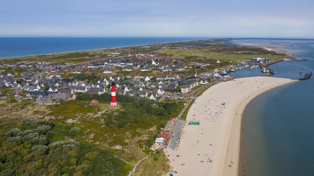
Lighthouse, Conch, and Tourism
Hoernum's municipal coat of arms is unusually direct about its identity: a red lighthouse against gold, with a blue base containing a golden conch horn - a pun on the village's name. The lighthouse on the arms is the real one, Hoernum Lighthouse, built in 1907, and it still flashes at the southern approaches to the island. The conch is the kind of detail a community chooses when it wants to be remembered as having one foot in the sea. Today the entire economy of Hoernum runs on tourism. A fast passenger ferry crosses each summer day to Amrum and to the Hallig of Hooge in the Wadden Sea. The Hoernum Odde, for all its erosion, draws hikers and birdwatchers in every season. A place that was uninhabitable until the twentieth century has become, in the twenty-first, one of the easier spots on Sylt to find a hotel bed - though the dunes, given their history, are not making any promises.
From the Air
Hoernum sits at the southern tip of Sylt at approximately 54.761 N, 8.291 E. The nearest airport is Sylt (EDXW) at Westerland, 15 km north on the same island. From cruise altitude Sylt is unmistakable - a long, thin north-south island with a sharp southern point - and Hoernum is the small cluster of buildings at that very point. The Hoernum Odde extends as a pale, finger-like sandbar pointing south toward Amrum, which lies about 12 km further south across the Hoernum Tief channel.
Nearby Stories
- Amrumbank West 26 km away
- German Bight 34 km away
- HMS Ariel (1911) 38 km away
- Tvindkraft Wind Turbine 138 km away
- Lilleø 173 km away
- Clausholm Castle 175 km away
- Wöbbelin Concentration Camp 217 km away
- Battle of Jutland 219 km away