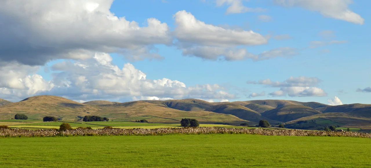

Howgill Fells
From the M6 the Howgills look improbable - smooth velvet humps rising abruptly out of the Lune Gorge, with none of the craggy theatricality of the Lake District peaks just to the west. Walkers call them sleeping elephants. The geology is the reason for that softness: while the Yorkshire Dales next door are built of pale Carboniferous limestone that fractures into scars and clints, the Howgills are made of much older Palaeozoic slates and gritstones that erode differently - rounded rather than cleft, sheep-cropped rather than scattered. The range sits in a kind of cartographic awkwardness, claimed at various times by Yorkshire and Westmorland and now divided between historic counties, and it took until 2017 for the whole range to be officially absorbed into the Yorkshire Dales National Park. They are upland between two more famous uplands, and they reward attention precisely because they have not been famous.
Geography of the Triangle
The Howgills sit roughly within a triangle formed by the town of Sedbergh in the south and the villages of Ravenstonedale and Tebay in the north. The River Lune defines their western edge, where the M6 motorway threads through the Lune Gorge - itself a major glacial meltwater channel cut during the last ice age. To the east lies the River Rawthey, beyond which rise the limestone country of the Yorkshire Dales proper. Two summits qualify as Marilyns - hills with at least 150 metres of prominence. The Calf reaches 2,218 feet (676 metres) and is the highest point in the range. Yarlside follows at 2,096 feet. Five further peaks are Hewitts. Cautley Crag, on the east-facing slope of the range, is the only well-developed glacial cirque - everywhere else the ice flowed across the smooth tops rather than carving cliffs out of them.
Older Than Most Things You Can See
The oldest rocks in the Howgills are Ordovician slates in the vicinity of Backside Beck in the east - around 445 million years old. The oldest Silurian rocks here are the laminated siltstones of the Stockdale Group, laid down in what was then a deep marine basin. Above these come more than 250 metres of dark grey mudstones and siltstones of the Brathay Formation. The larger part of the range is built from the sandstones of the Coniston Group, roughly a kilometre thick in total. These were folded into a broad east-west anticline and syncline during a Caledonian mountain-building event when continents collided. Then, much later, the British ice sheet rolled across them during successive glaciations, smoothing the tops, leaving glacial till in the valleys, and dumping debris cones in the side valleys of Langdale and Bowderdale. Cautley Spout cuts down through scree along this margin in a series of dramatic falls.
The Norse Name
The word Howgill is Old Norse: haugr meaning a hill or barrow, and gil meaning a narrow valley. The Norse settled the western fells of northern England heavily in the ninth and tenth centuries - their place names cluster across Cumbria more densely than almost anywhere else outside Iceland. A howgill is the kind of place where you have both elements at once - a rounded hill cut through by a sharp ravine - and it described what these settlers found here exactly. Every steep-sided beck cutting down from The Calf or Yarlside fits the description. The naming has held for more than a thousand years; the landscape has held for considerably longer. The fells were grazed by Norse, Cumbric and Anglo-Saxon sheep over the centuries, and they are still grazed - the close-cropped turf that gives the range its smooth appearance is a thousand-year cultural artefact as much as it is a geological one.
The Walk and the Weather
Alfred Wainwright wrote about the Howgills with the affection of a man who had grown tired of crowds on Helvellyn. The walking is different here from the Lake District: less rocky scrambling, more sustained climbing on grass and bracken slopes, with long ridge walks linking summit to summit once you gain the height. Weather can change fast at this latitude. Maritime air from the Irish Sea collides with northern continental fronts, and what looks like a clear summer morning becomes a cloud-wrapped fell by lunchtime. Peat is found on some hill spurs but is not extensively developed - which means the going is firm in most weather, an unusual mercy in this part of England. Since 2017 the entire range has been formally part of the Yorkshire Dales National Park, and visitor numbers have started to climb. The Howgills have been waiting.
From the Air
The Howgill Fells are centred around 54.40 degrees north, 2.50 degrees west, with The Calf summit at 2,218 feet and Yarlside at 2,096 feet. The range forms an oval of high ground between the Lake District (to the west) and the Yorkshire Dales (to the east), bounded by the Lune Gorge and M6 motorway on the west. Best viewed from 4,000-6,000 feet AGL. Carlisle (EGNC) lies approximately 40 nautical miles north; Leeds Bradford (EGNM) is about 45 nautical miles southeast. Watch for rapidly changing weather, lenticular cloud, and rotor turbulence in the lee of the Lake District peaks on westerly winds.
Nearby Stories
- Hardknott Pass 2.1 km away
- Furness Abbey 2.3 km away
- Ireby 8 km away
- Cross Fell 10 km away
- Weardale Railway 11 km away
- Morecambe Bay Cockling Disaster 13 km away
- Bolton Castle 14 km away
- 1975 Dibbles Bridge Coach Crash 15 km away