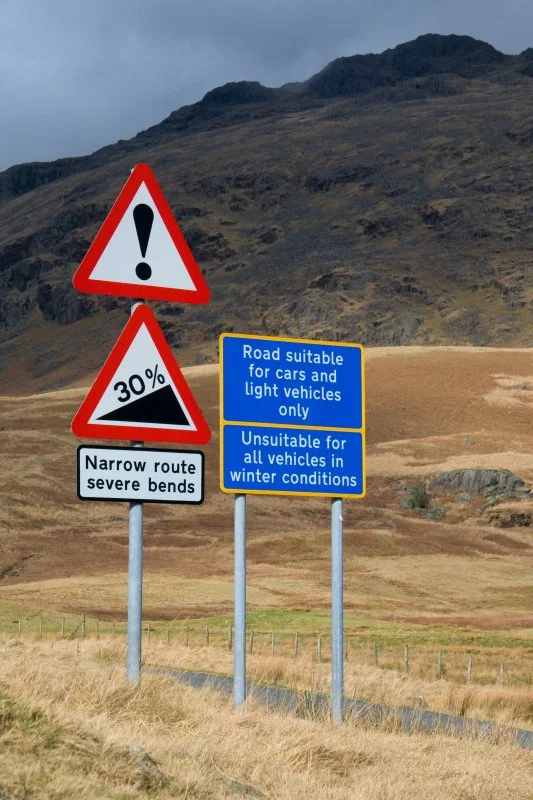

Hardknott Pass
The road warns you before it climbs. Loose hairpins. Single track. Steep gradient ahead. Ignore the signs and you reach a point - somewhere on the western ascent out of Eskdale - where the tarmac tilts so abruptly that your sightline simply disappears over the bonnet, replaced by sky. A maximum gradient of 1 in 3, about 33 percent: Hardknott Pass shares with Rosedale Chimney Bank in North Yorkshire the title of steepest road in England, and it is the only one of the two that climbs through a Roman fort.
A Hard, Craggy Hill
The name is older than the road. Hard Knott comes from Old Norse - harthr meaning hard, knutr meaning craggy hill - the kind of place-name Scandinavian settlers left across northern England like a low-resolution map. The pass itself summits at 393 metres, threading between the upper end of Eskdale on the west and the head of the Duddon Valley on the east, where it meets the equally savage Wrynose Pass. Cockley Beck farm, built in the 1860s and now owned by the National Trust, sits at the eastern foot. To the west, Harter Fell shoulders up above the road, and the remains of a Roman fort cling to a rocky spur 200 metres above sea level. The Highway Code rule for the pass is unambiguous: traffic going uphill has priority. Anyone who has tried to reverse a car backwards down a 1-in-3 gradient with a stone wall on one side and a cliff on the other will understand why.
The Tenth Highway
Around AD 110, Roman engineers cut a road over this pass. They called it the Tenth Highway, and its job was to link the coastal fort and bath house at Ravenglass with the inland garrisons at Ambleside and Kendal. When the Romans withdrew from Britain in the early 5th century the road was left to weather. By the early Middle Ages it had become an unpaved packhorse route known as the Waingate or Wainscarth - cart road, cart pass - hauling lead and farm goods between coast and dale. There is a record from 1138 of monks crossing it in an oxcart, which gives some sense of the scale of the patience required. The land itself fell within the domain of the Lords of Millom, sitting between the headwaters of the Esk and the Duddon. In the 13th century the monks of Furness Abbey were granted grazing and hunting rights here, which they held until the Dissolution of the Monasteries between 1536 and 1541 ended their tenure.
Cruel Coming East
Modern attempts to civilise the pass have a long, slightly comic history of failure. In the 1880s an association of hoteliers called the English Lake District Association financed road improvements, hoping carriages full of tourists would soon clatter over the top. By 1891 their scheme was judged, in the prim phrasing of the day, "not the success that was anticipated." The Cyclists' Touring Club guidebook of 1911 described the old coach road as "difficult going West, cruel coming East" - a phrase any modern cyclist on the climb will recognise. The first motor vehicles were brought over in 1913 from the Eskdale side. In 1936 the Cumberland Highways Committee rejected a proposal to widen and resurface the road. Then the Second World War intervened: the War Office used the area for tank training and so thoroughly destroyed the road surface that after the war the only practical option was to lay tarmac. A pass that local government had refused to open to cars in 1936 ended up paved a decade later, by accident, by tanks.
Tour de France Gradients
Cyclists call it England's hardest climb, and they have evidence. The 1-in-3 sections are steeper than the mountain stages of the Tour de France and the Giro d'Italia, and the pass is part of the annual Fred Whitton Challenge, a 112-mile sportive around the Lake District that uses Hardknott as one of its closing ordeals. In 2019, Eurosport made a documentary called England's Toughest Climb in which an average cyclist trained for six weeks specifically to ride this road. He failed. In winter the pass is regularly closed by ice that turns the steep slabs into slides. The Roman engineers, working out the line of the Tenth Highway, took a different route from the modern road - their highway lies to the north of today's tarmac on the western side, and to the south on the eastern side. Eighteen centuries later, somebody is still trying to find the kindest way over a hill that does not want to be crossed.
Flight Context
Hardknott Pass crosses near 54.40 degrees north, 3.20 degrees west, at a summit elevation of 393 metres (1,289 feet). From the air the pass is recognisable as a switchbacked ribbon of tarmac threading west to east between Eskdale and the Duddon Valley, with the Roman fort visible as a square enclosure on the spur just below the western ascent. Best viewed at 4,000 to 6,000 feet AGL; the surrounding fells produce significant rotor in westerly winds. Nearest airfields: Walney Island Barrow (EGNL) about 22 nm south, Carlisle Lake District (EGNC) about 35 nm north.
From the Air
Hardknott Pass at 54.40 N, 3.20 W, summit 393 m. From above, identify by the switchbacked tarmac between Eskdale (W) and Duddon Valley (E), with the Roman fort on the western spur. View from 4,000-6,000 ft AGL; significant rotor turbulence in westerly winds. Nearest fields: Walney Island Barrow (EGNL) about 22 nm S, Carlisle Lake District (EGNC) about 35 nm N.
Nearby Stories
- Isel Hall 3.3 km away
- Walney Island 7.1 km away
- Kendal 9.7 km away
- Lancaster Priory 10 km away
- Raeberry Castle 15 km away
- Cross Fell 21 km away
- Ramsey Bay 29 km away
- Santon Railway Station 47 km away