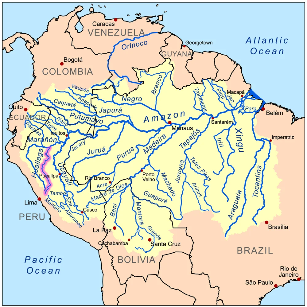
Huallaga River
In September 1966, a Hollywood actor named Eric Fleming climbed into a dugout canoe on the Huallaga River in northern Peru for location filming on an ABC television production called High Jungle. Fleming had just finished eight seasons as trail boss Gil Favor on Rawhide - the long-running television Western that launched Clint Eastwood's career. The canoe capsized in the river's current. Fleming was swept away and drowned. His body was pulled from the water three days later, miles downstream. The Huallaga did what the Huallaga had been doing for centuries: it took what it wanted and did not return it on a schedule.
Forty-two Rapids to the Amazon
The river is born on the slopes of the central Peruvian Andes and runs 700 miles northeast before joining the Maranon on its way to form the Amazon. Old Spanish maps called it the Guallaga or the Rio de los Motilones. For most of that length, the Huallaga is unnavigable - an impetuous torrent, in the old geographer's phrase, hammering through a succession of gorges. Forty-two distinct rapids (Peruvians call them pongos) interrupt the flow. One of them, the Pongo de Aguirre, is where the river finally cuts through the Andes and settles into jungle. From there, 140 miles above the Amazon, larger boats called lanchas can climb upstream as far as Yurimaguas in Loreto region. Everything above that point moves on smaller craft or on foot.
The Pampa del Sacramento
Between the Huallaga and the Ucayali stretches a legendary piece of Amazonian flatland known as the Pampa del Sacramento - about 300 miles long, 40 to 100 kilometers wide, covered in dense dark forest. The first Christian missionaries entered it in 1726. Streams navigable by canoe thread the interior, and indigenous communities including the Cocama-Cocamilla and Kichwa-Lamista peoples have lived there for generations that predate any map. In the river itself, wildlife continues to resist cataloguing. Eighteen distinct frog species have been documented in the Huallaga basin, including Epipedobates boulengeri, Hyloxalus pulchellus, and Ranitomeya reticulata - the last a reticulated poison frog whose skin holds compounds that indigenous hunters have used on blow darts for centuries.
The Coca Valley
Since the 1980s, the Upper Huallaga Valley has been the primary coca-growing region in Peru. The leaves are processed and flown to Colombia, where they become cocaine bound for the United States. Vladimiro Montesinos, former head of Peru's intelligence service, was reported to have received $50,000 for every plane allowed to leave the valley with its cargo. On August 27, 1994, a Drug Enforcement Administration CASA 212 Aviocar light transport crashed into mountainous terrain north of Puerto Pizana in San Martin region. The flight had left Santa Lucia bound for Pucallpa on a counter-narcotics reconnaissance mission in heavy rain and low visibility. Five DEA agents died: Frank S. Wallace, Jay W. Seale, Juan C. Vars, Meredith Thompson, and Frank Fernandez Jr. The crash ended Operation Snowcap, the U.S. anti-drug effort under which the flight had been operating.
What the River Carries
The Huallaga today carries more than water. Point-source pollution is routine along the populated stretches. At least one chute has been built specifically to dump garbage trucks into the current. The river floods periodically, and the coca farmers, subsistence farmers, and indigenous communities who live in its valleys have all learned to move livestock and belongings upslope when the rains come hard. The divisions between Upper, Central, and Lower Huallaga are loose - Upper from Tocache in San Martin up toward the source, Central from Tocache or Juanjui down to Chazuta, Lower from Chazuta to Yurimaguas. None of the lines are official. The river does not respect them anyway.
Yurimaguas and the Long Descent
Yurimaguas, at the confluence with the Maranon, is where the Huallaga effectively ends as a distinct river. It sits at roughly 180 feet of elevation, a port city in the lowland Amazon jungle, its dock crowded with river boats loading bananas and aguaje palm fruit for the trip downstream. From here, the water joins the Maranon, then the Amazon itself, and continues eastward for more than 3,000 miles to the Atlantic. Somewhere in that long descent, whatever the Huallaga carried from the Andes - silt from the nitrate country, runoff from the coca fields, leaves from forests that have never been properly surveyed - gets folded into the biggest river system on Earth. Eric Fleming's body eventually surfaced. Most of what the Huallaga takes does not.
From the Air
Centered near 5.10 degrees S, 75.60 degrees W in Peru's San Martin and Loreto regions. The Huallaga River runs roughly north-northeast from the central Andes to its confluence with the Maranon near Yurimaguas. Viewing altitude 6,000-10,000 ft reveals the dramatic transition from Andean foothills to the western Amazon lowlands. Key visual landmarks include the Pongo de Aguirre gorge, the town of Tocache, and Yurimaguas at the lower terminus. Nearby airports include Captain Guillermo Concha Ibérico (SPYL) at Yurimaguas and Cadete FAP Guillermo del Castillo Paredes (SPMS) at Tarapoto. Weather in this region turns quickly - the crash that ended Operation Snowcap happened in heavy rain and fog. Clear morning visibility is your best window.
Nearby Stories
- Peruvian Amazonia 24 km away
- 2005 Northern Peru Earthquake 28 km away
- Iquitos Varzea 53 km away
- 2021 Northern Peru Earthquake 78 km away
- Moyobamba 121 km away
- Department of Loreto 144 km away
- 1990-91 Alto Mayo Earthquakes 165 km away
- Borja, Peru 204 km away