
Humberston Fitties
Every winter, by rule, residents of the Humberston Fitties must vacate their chalets between four in the afternoon and half past nine the next morning, throughout January and February. The rule is strictly enforced. The point is not to make anyone uncomfortable. The point is to preserve what one chalet owner called the 'impermanent spirit' - the idea that this place is a holiday camp, not a town, and that everything here is meant to feel slightly provisional, even after a hundred years. The Fitties has been resisting its own permanence since the 1920s, when families first moved into the disused army huts the soldiers had left behind.
Foreshore Saltings
The name comes from Norse. Fitjar meant foreshore saltings - the marshy grassland where the sea licks the land. Vikings settled this coast in the ninth and tenth centuries, and they left their words behind in the place names. In 1960 the Grimsby Rural District Council tried to change the name to 'Humberston Dunes Holiday Camp' because they considered 'fitties' unattractive. The idea went nowhere. In the early twentieth century the place had cycled through other names - Humberston Lido, Great Bear Camp, Halle Sands - but always came back to what the people who lived here actually called it. Fitties. The same word still appears up and down the Lincolnshire coast: North Cotes Fitties, Tetney Fitties, all marking the same kind of in-between land between dune and beach.
From Army Huts to Plotland
During the First World War, the army built billets in the dunes for soldiers stationed at Haile Sand Fort just offshore. The Manchester Regiment trained here. Pickets watched the coastline between Cleethorpes and Tetney Lock for German raiders. When the war ended and the men went home, families moved into the empty huts. Holiday-makers followed in caravans, buses, and converted railway carriages - whatever could be hauled onto the dunes and made watertight. By 1925 the residents had organised themselves into the Humberston Fitties Campers' Association. In 1938 Grimsby Rural District Council bought three hundred and thirty acres to create what they called a 'first class camping ground' for families from the Midlands who otherwise never saw the sea. The Fitties were already what they wanted to remain: a working-class seaside democracy of plywood and tarpaper.
The Sea That Tries to Take It Back
In 1921 an abnormal tide washed away several bungalows. In 1953 a storm surge breached the dunes. The council planted marram grass, drove in brushwood fencing, and spent six thousand pounds on more dune defences in 1956. In 1958 the Department of Scientific and Industrial Research declared the Fitties a 'potentially dangerous area' and recommended a sea wall, more groynes, and the planting of two thousand Corsican and Scotch pines. The money was not there. Instead the council agreed simply to warn renters of the risk. In 1961 the dunes were found to have eroded by two thirds of their length. Between 1961 and 1964 the authorities built eighteen thousand pounds' worth of gabions and groynes. Within two years the sand had scoured out from beneath them and the contents washed away. The Fitties has spent a century in a slow argument with the North Sea about who gets the last word.
Bungalow Town
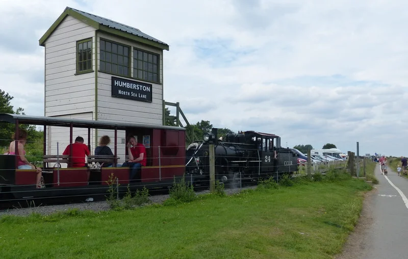
By 1947 there were sixty huts and bungalows. By 1956 there were three hundred. At peak season as many as six thousand people could be accommodated. A doctor's surgery opened in 1960, along with a grocer, a general store, and a fish-and-chip cafe. 'Walkie pictures' photographers handed out cards inviting holidaymakers to a kiosk later to buy souvenir snapshots. Donkey rides ran along the beach. A bus from Cleethorpes via the zoo carried sixty-seven thousand passengers in August 1967 alone. Britain's shortest public passenger railway, a two-foot narrow-gauge line salvaged from the potato fields at Nocton, ran six hundred metres between North Sea Lane and South Sea Lane with volunteers at the throttle. None of this looked like a planned resort. All of it looked like what it was: a place people made for themselves out of what was left over.
The Threat From the Council
In 1986 the First Leisure Corporation, owners of Blackpool Tower, tried to buy the Fitties for six million pounds. Chalet owners protested - the council had not offered them first refusal on their own freeholds. The deal collapsed in March 1987. Two years later Whitegate Leisure proposed turning the place into 'South Beach Holiday Village,' an up-market resort with supermarkets, fast food, a nightclub and a cabaret room. That plan was rejected in 1991. In November 1995, eight hundred chalet owners signed a petition demanding the Fitties be designated a conservation area. In March 1996, with backing from the Twentieth Century Society, they got it. The 27-hectare site was preserved on the grounds that, while it did not have the elements normally associated with a conservation area, it had a special character and historic interest worth keeping. The Article 4 direction came in 1998. After what owners called a 'fifty-year crusade for plug power,' the original three hundred and thirty chalets were finally wired to the grid in May 1999.
What You See From the Air
From altitude, the Fitties shows itself as a fine-grained maze - tiny wooden boxes arrayed along sandy lanes between a strip of dune and an inland lagoon. The lagoon is the third most important saline lagoon in Britain, a Site of Special Scientific Interest where sanderling, grey plover, dunlin, and shelduck feed in the saltmarsh pools. The most northerly British population of the sand shrimp Gammarus insensibilis lives in its brackish water. Beyond it, Haile Sand Fort rises eighteen metres above the sea on its forgotten gun platform. Beyond that, the long arm of Spurn Point curls into the Humber's mouth. The Fitties was Britain's first 'Quality Coast Award' winner in 2007, recognised for 'Best Places to Go for Coastal Isolation.' It is still that. The chalets are still wooden, still individual, still maintained by their owners. And every January, by rule, the place empties for two months.
From the Air
The Humberston Fitties sit at 53.53°N, 0.01°E on the Lincolnshire coast immediately south of Cleethorpes. Recommended viewing altitude is 1,500-2,500 feet AGL to take in the chalet grid, the lagoon to landward, and the dune strip facing the North Sea. Haile Sand Fort is plainly visible offshore. The nearest airports are Humberside (EGNJ) about ten miles to the west and the disused RAF North Coates immediately to the south. Watch for the restricted airspace over the Donna Nook bombing range, and for shipping in the deep-water channel of the Humber. Best light is morning easterly, when the sun picks out the white-painted chalet roofs against the marsh.
Nearby Stories
- Westermost Rough Wind Farm 2.5 km away
- Silver Pit 5.4 km away
- Beverley Minster 7.4 km away
- Lincoln Cathedral 13 km away
- 2004 Ingoldmells Bus Crash 14 km away
- Humber Bridge 21 km away
- Holkham National Nature Reserve 33 km away
- SMS Blucher 333 km away