Ilha de Santana Lighthouse
The sea keeps winning here. Four lighthouses have stood at the east entrance of Sao Marcos Bay in Maranhao since 1831, each built a little farther back from the water than the one before, each eventually undermined by the same patient Atlantic. The current tower, a 49-meter cylinder of concrete lit on July 1, 1964, now carries the light for the entire sequence. Inside its lantern, the same rotating optical apparatus has been moved from tower to tower, an inherited mechanism that has outlasted every structure built to hold it. On Ilha de Santana, the problem of keeping a flame in one place has been an engineering project spanning three centuries.
The First Tower, 1831
Construction was authorized in June 1822, just months after Brazilian independence, though the first lighthouse on Ilha de Santana did not actually light until June 1, 1831, after three years of masonry work. The builders had placed the tower close to the beach, in a location without local stone, which meant hauling every block across difficult ground. The finished structure stood 31 meters high and carried a rotating catoptric lens, a mirror-based optical system with a range of 18 nautical miles. It did not last long. The sea began eroding the ground around it almost immediately. Engineers tried to save the original lighthouse, but their efforts failed. The Atlantic was going to reclaim that particular piece of coast no matter what was built to resist it.
The English Skeleton Tower
The most distinctive lighthouse in the sequence was the third, lit on December 2, 1883. It was a pyramidal skeletal tower of cast iron, prefabricated in England by Armstrong, Mitchell and Company and shipped in pieces to be bolted together on the Brazilian coast. Its lantern held a second-order Fresnel lens built by Chance Brothers, the same Birmingham glassworks that had revolutionized lighthouse optics worldwide in the mid-19th century. The new lamp emitted alternating white and red flashes, the colored sector warning ships away from particular hazards inside the bay. Cast iron was supposed to last. Salt air and tropical humidity had other plans. Rust worked into the structure decade by decade, and by the mid-20th century, the lighthouse was too corroded to continue in service safely.
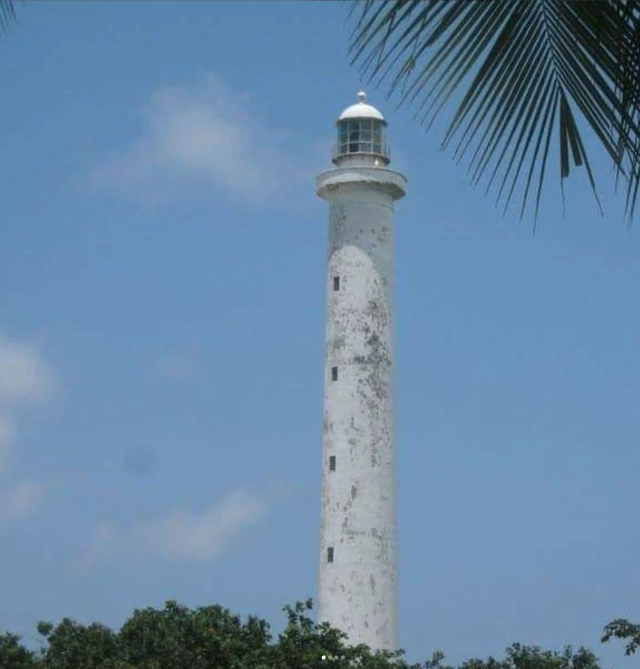
Concrete and Inheritance
The current tower is the fourth generation. Concrete, cylindrical, 49 meters high, it was commissioned on July 1, 1964, specifically designed to resist what had destroyed its predecessors. The old cast iron tower was partially dismantled at that point, and the remainder was taken down entirely some years later. One element was salvaged and moved across: the optical device itself, the rotating lens and lantern assembly, was carefully transferred from the 1883 English iron structure to the 1964 concrete tower. The light that shines out over Sao Marcos Bay today is the same light, mechanically speaking, that shone from the skeletal tower. Its signature now reads as two long alternating white flashes and one red every 51 seconds, visible up to 31 nautical miles for the white and 25 for the red.
Why Ships Need This Light
Sao Marcos Bay is the deep water approach to Sao Luis, the capital of Maranhao, and to Ponta da Madeira, one of the largest iron ore export terminals in the world. Bulk carriers loaded with ore from the Carajas mine complex swing into this bay on a schedule measured in minutes, and the east entrance that Ilha de Santana guards is the one they use. The red sector of the light marks specific shoals and reefs; the white sector indicates safe passage. The Brazilian Navy manages the lighthouse, which carries the country code BR-0804 in the international lighthouse register. In a coastline full of automated modern lights, this tower is both a still-working navigation aid and a monument to how much effort has gone into keeping this particular piece of water marked.
The Slow Argument with the Shore
The story of Ilha de Santana is really the story of coastal erosion at tropical latitudes, where the combination of Atlantic storm swells, river-mouth sediment movement, and long-period wave action can remove a beach in less than a lifetime. Each lighthouse on this island was an honest attempt to solve a problem that was actually a moving target. The island is still moving. The concrete tower has held its ground for over sixty years so far, a longer run than any of its predecessors managed, but the same forces that ate the first three are still at work. Whether the fourth lighthouse will still be standing when the original authorization of 1822 reaches its three hundredth anniversary is a question that the Atlantic, as ever, will answer on its own timetable.
From the Air
Ilha de Santana Lighthouse sits at 2.27 degrees south, 43.62 degrees west, on a small island at the east entrance of Sao Marcos Bay in Maranhao, northern Brazil. Structure height is 49 meters with an additional short base elevation. Best viewing altitude is 2,000-4,000 feet above the bay for visibility of the tower and the surrounding bulk-carrier shipping traffic. The nearest airport is Sao Luis-Marechal Cunha Machado International (SBSL), roughly 30 nautical miles south-southwest. The port of Ponta da Madeira, one of the world's largest iron-ore export facilities, is clearly visible inside the bay. Trade winds from the east-northeast are consistent most of the year.
Nearby Stories
- Equinoctial France 7.4 km away
- Lençóis Maranhenses 16 km away
- Alcântara Space Center 23 km away
- Queimada dos Britos 40 km away
- Munim River 47 km away
- Maranhão mangroves 61 km away
- Parcel de Manuel Luís Marine State Park 129 km away
- Nadir Crater 3160 km away