Lençóis Maranhenses
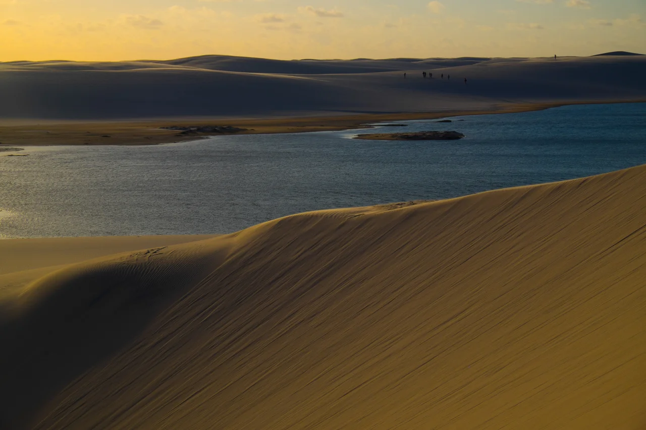
You crest a dune, and the desert lies to you. Between the white ridges, cupped in hollows that were dry sand a month ago, lakes the color of bottle glass catch the afternoon sky. Lençóis Maranhenses is not a desert at all, despite appearances. It receives some of the heaviest rainfall in Brazil's northeast, and for roughly half the year the valleys between its dunes become a lattice of freshwater pools - thousands of them, scattered across more than 155,000 hectares of shifting sand.
The Contradiction at the Edge of the Atlantic
The name translates roughly to "Maranhão bedsheets," and from above the comparison makes perfect sense. The dunes ripple in long, crested rows, their crests catching light the way linen does when it is hung to dry. But the trick is the water. Between December and May the rains come hard and steady, and because there is a layer of impermeable rock beneath the sand, the rainwater has nowhere to drain. It pools. By May or June the lakes are at their deepest, some large enough to swim across, and tiny fish - somehow - appear in them, carried through as eggs in the mud of returning birds. By September the sun and wind have taken most of the water back. The park was created in 1981 to protect all of this, and motor vehicles are banned inside its boundaries. The dunes move. A road would be pointless.
Arriving, and Why It Takes Effort
Most travelers come through Barreirinhas, the gateway town on the Preguiças River. The road in from São Luís takes about four hours, and Barreirinhas is where the day tours form up - 4x4 vehicles bouncing across the hardpan to Lagoa Azul or Lagoa Bonita, both within striking distance of the park's eastern edge. That is the easy version. The harder, better version is to sleep in Atins or Canto de Atins, small fishing villages on the river mouth, and walk in from there. The dunes stretch sixty kilometers west from Atins to Santo Amaro do Maranhão, and trekkers who cross them spend three or four days in a world with no roads, no power lines, and almost no other people. The sand, packed firm by rainy-season weather, walks more easily than any beach you have crossed.
Life on the Sand
The biodiversity is a surprise. More than 120 bird species have been recorded in the park, some of them nesting in the scrub along the dune edges and others feeding in the lake shallows. Scarlet ibis, neotropical otters, oncillas - the small spotted wildcat of the Brazilian northeast - and West Indian manatees are all here, all endangered, all somehow holding on. At least forty reptile species live in the dunes themselves, a feat that still surprises biologists. Two interior oases, Baixa Grande and Queimada dos Britos, hold small communities of families who have lived on the sand for generations. They raise goats and chickens, they fish the lakes, and they rent out hammocks to trekkers for the night. Dinner is rice and beans and whatever was caught that day.
The Hour the Dunes Belong To
Come an hour after sunrise, if you can manage it. The temperature is still cool, the wind has not yet picked up, and the low sun lays shadow into every trough and crest. Watching it from a high dune feels like watching a slow tide - the shadows lengthen and shift as the sun climbs, and the lakes below change from black to green to blue. The east-to-west traverse is the standard direction for a reason. The prevailing wind blows from behind you, the steep lee slopes face your line of travel, and the sand that inevitably gets into everything is at least working with you rather than against. Bring three liters of water per person per day. The breeze disguises the sun, and the sun in this latitude does not forgive.
Leaving Less Than You Brought
There are no fees to enter Lençóis Maranhenses. There are also no trash receptacles, no toilets, no shelters - nothing but sand and wind and water. Whatever you carry in, you carry out. The park's managers have begun debating whether to restrict camping because of garbage that earlier visitors left behind, and the careful traveler does not want to be the reason those restrictions come down. The dunes that look permanent move several meters each year. The lakes that look permanent will be gone in October. The only thing the park asks is that you leave it the way it was before you came - because in six months the sand and rain will have erased all evidence that you were there at all.
From the Air
Coordinates 2.53°S, 43.12°W. Recommended viewing altitude 3,000-5,000 feet to trace the dune-and-lake patchwork; at 10,000+ feet the scale is visible but the individual lakes blend into the sand. Landmark: the Preguiças River forms the park's eastern boundary, emptying into the Atlantic at Atins. Nearest airport is Marechal Cunha Machado International (SBSL) in São Luís, 260 km to the west. Visibility is best May through September after the rains fill the lagoons; expect haze and convective buildups during the December-April wet season.
Nearby Stories
- Ilha de Santana Lighthouse 3.7 km away
- Paulino Neves 19 km away
- Munim River 59 km away
- Araioses 71 km away
- Metal Open Air 87 km away
- Chapada Limpa Extractive Reserve 135 km away
- Maranhão mangroves 201 km away
- German submarine U-164 (1941) 354 km away