Itatiaia National Park
In June 1985, it snowed. Thick, memorable, unusual snowfall blanketed the peaks of Itatiaia National Park in southeastern Brazil - a country where 93 percent of the land sits in the tropical zone and snow is a story told mostly in disbelief. The Pico das Agulhas Negras, the park's highest summit, routinely drops to -10°C in the austral winter, and the 1985 storm was the third-heaviest snowfall ever recorded in Brazil. Most years, the cold stops at frost on the alpine meadows and ice on the puddles. The snow is the exception. But the fact that it can snow at all, at this latitude, tells you most of what you need to know about Itatiaia.
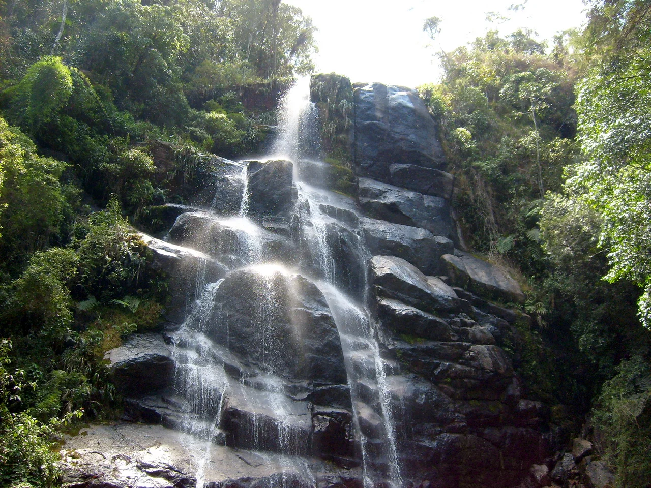
The First National Park
Parque Nacional do Itatiaia was established in 1937 under President Getúlio Vargas, making it the oldest national park in Brazil. It sits at the border between Rio de Janeiro and Minas Gerais states, tucked into the Mantiqueira mountain range between 22°16' and 22°28' South and 44°34' and 44°42' West. Though the park sits not far inland from the Atlantic Ocean, it covers a remarkable range of elevations, rising from lower-altitude Atlantic Rainforest to alpine meadows wrapped around granite cliffs. The name is Tupi: *itatiaia* means *many-pointed rock*, a description that fits the jagged skyline of the high country. The park is divided into two zones. The lower zone, near the city of Itatiaia, holds the Véu da Noiva waterfall - a 45-meter drop - and a natural history museum. The upper zone, accessible through a separate entrance about 35 kilometers from the main gate, climbs toward Pico das Agulhas Negras and the Prateleiras rock formation.
Black Needle Peak
Pico das Agulhas Negras - *Black Needles Peak* - is Brazil's fifth-highest mountain and the highest in Rio de Janeiro state. The peak is visible to the northwest of Resende for drivers on the Via Dutra highway between São Paulo and Rio de Janeiro, the busiest stretch of road in the country. From the summit, the view takes in the Funil Dam reservoir, the Sierra Fina, the mountain resort region of Visconde de Mauá, and the vast Vale do Paraíba valley where Brazil's most populous cities cluster along the Rio-São Paulo axis. The climb is not technical, but it requires real effort - some scrambling, though not rope-work mountaineering. Prateleiras, the adjacent formation, is an easier climb and offers comparable views. Both draw mountaineers, trekkers, and rappellers in significant numbers. A few years ago, an arson attack started a fire that destroyed most of the vegetation in the high country; it has since recovered, but access is now restricted to visitors accompanied by a registered guide. The access road from the secondary gate is rough enough that most agencies provide 4x4 transport.
The Birds
Itatiaia is one of the best bird-watching destinations in southeastern Brazil. The park holds approximately 250 species, distributed across its elevation range. The altitudinal variety is the key: lowland Atlantic Forest birds mix with high-altitude specialists you cannot find elsewhere in the region. The surrounding Mantiqueira Mountain Environmental Protection Area serves as an ecological buffer zone, extending the forest cover that supports the park's avifauna. Serious birders come from every continent. Casual visitors notice the density almost immediately: every walk into the forest produces calls from a dozen directions, flickers of movement in the understory, and - if you know where to look - occasional sightings of species that do not appear elsewhere in easy travel range.
The Finnish Colony
Just outside the park boundary, at the foot of the Serra da Mantiqueira at 600 meters elevation, lies the town of Penedo - the best-equipped tourism base in the region. Its origin is surprising: Penedo was founded in 1929 by Finnish natural scientists who wanted to build a tropical vegetarian community in the Brazilian mountains. The colony did not entirely succeed as a utopian project, but it took root, and its descendants still live in the area. The architecture is Nordic-influenced, the local culture preserves Finnish traditions, and the town's hotel and restaurant network - 52 hotels, 39 restaurants, snack bars, and cafes - makes it a natural base for park visitors. Penedo sits 3 kilometers north of the town of Itatiaia and 170 kilometers northwest of Rio de Janeiro.
Inside the Park
Unusually for a Brazilian national park, Itatiaia has lodging within its boundaries. Small hotels - *pousadas* - and one larger hotel operate inside the park itself. The Donati is the best-known of the small ones: fairly expensive, with all meals included, situated in a forest clearing with 24-hour access to the trails. For hikers who want to be inside the park at dawn, when the birds are most active, the logistical advantage is significant. A dark shadow falls across one corner of the park's history. In the upper zone, after the Second World War, the Nazi physician Josef Mengele - responsible for medical experiments on prisoners at Auschwitz - lived for a period while evading capture in South America. He was one of a number of fugitives who used Brazil's rural interior to disappear; the park itself had nothing to do with his presence, but his residence in the area is part of the historical record. The park today is what visitors experience: forested slopes, granite peaks, alpine meadows, hundreds of bird species, and the rare Brazilian possibility of snow. It is the oldest of Brazil's national parks and still, by many measures, one of the best.
From the Air
Located at 22.35°S, 44.65°W at the border between Rio de Janeiro and Minas Gerais states. Pico das Agulhas Negras rises to approximately 2,792 m, making it Brazil's third-highest peak and the most prominent feature visible from the air. Nearest airports: Resende Airport (SDRS) about 30 km south, or São Paulo/Guarulhos (SBGR) or Rio de Janeiro/Galeão (SBGL) for larger aircraft. Best flown in dry winter months (May-September) when visibility is clearest and snow may occasionally dust the high peaks. Recommended viewing altitude: 10,000-14,000 ft to see the full Mantiqueira range and the alpine meadows of the upper park.
Nearby Stories
- Itajuba 11 km away
- Campos do Jordao 26 km away
- Basilica of Our Lady of Aparecida 46 km away
- Cambuquira 58 km away
- Ibitipoca State Park 63 km away
- Varginha UFO Incident 65 km away
- Miguel Pereira 85 km away
- Christ the Redeemer: The Statue Built from Soapstone Carried Up a Mountain 116 km away