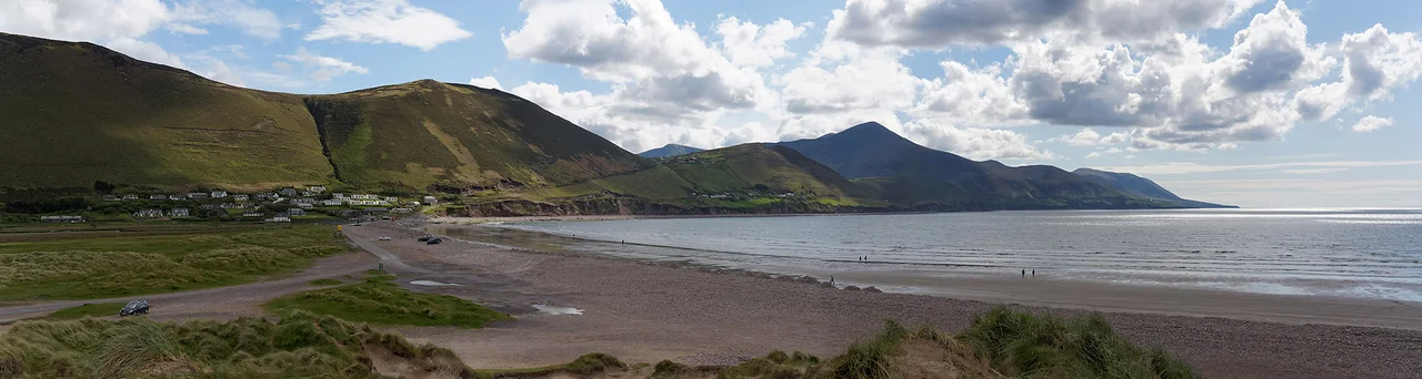

Iveragh Peninsula
Ireland's south-western coast is shaped like the splayed fingers of a hand reaching into the Atlantic. The middle finger of those fingers, the longest and largest, is the Iveragh Peninsula. At its centre stands MacGillycuddy's Reeks, the highest mountain range in Ireland, with Carrauntoohil at 1,038 metres - the highest peak on the island. Around the coast runs the Ring of Kerry, the most-driven scenic route in the country. Off the western tip lie the Skellig Islands, sharp-edged rocks where 6th-century monks built a monastery clinging to a cliff and where, in 2014 and 2015, Lucasfilm filmed the closing scenes of Star Wars: The Force Awakens. The peninsula contains, in roughly equal measure, the geological extreme, the romantic landscape and the cinematic backdrop.
The Reeks and the Highest Point
MacGillycuddy's Reeks - the awkward English version of the Irish Cnoc na Toinne and surrounding peaks - run east to west through the centre of the Iveragh. The range is named after the MacGillycuddy family, a Gaelic clan who once dominated the local lordship. Carrauntoohil itself rises to 1,038 metres, modest by Alpine standards but the highest in Ireland, and the climb up its eastern flank via the Devil's Ladder is one of the country's classic hill walks. The Reeks are also some of the geologically oldest mountains in Europe, ground down by millions of years of erosion and then carved into their current shape by Ice Age glaciers. Corries, ridges, and dark glacial lakes called coums are scattered across the range. The weather here changes hourly. Sunshine on the summit is rare and treasured.
The Ring of Kerry
The Ring of Kerry is a 179-kilometre driving route that circles the Iveragh, beginning and ending at Killarney. Tour buses travel anticlockwise to avoid meeting each other on the narrow western stretches. The route takes in Killorglin (where the Puck Fair crowns a wild mountain goat as king each August), Cahersiveen, Waterville (where Charlie Chaplin holidayed for years), Sneem (the village whose Irish name means 'the knot'), and Kenmare. The Skellig Ring is a smaller loop that breaks off the main route to take in the Atlantic edge - Portmagee, Valentia Island, and the closest viewpoint of the Skellig Islands. Most visitors do the Ring in a day. The peninsula rewards slower travel.
The Islands Off the Edge
Twelve kilometres off the west coast of the Iveragh, the Skellig Islands rise from the Atlantic in two sharp pyramids. Skellig Michael, the larger of the two, was an early Christian monastic site from around the 6th century. Monks built a small village of corbelled stone beehive huts on a ledge near the summit, 218 metres above the sea, and lived there in apparent austerity for about 600 years. The buildings are still there, accessible by boat in summer when the swell permits and after a climb of 600 stone steps. Since 2014 and 2015, when Star Wars filmed the final scenes of The Force Awakens here and the opening scenes of The Last Jedi, tourist demand has been intense enough that boat numbers are now strictly limited. The Little Skellig nearby is closed to landings and is home to one of the world's largest northern gannet colonies.
Stone Forts and Dark Skies
The Iveragh is dense with prehistoric and early historic sites. Cloghanecarhan is a ringfort with a 7th-century ogham stone, Leacanabuaile is a stone cashel near Cahersiveen, Loher Cashel sits at the western edge. Staigue stone fort, 18 km west of Sneem, has walls 18 feet high and 13 feet thick, built without mortar around AD 300-400. Eightercua at Waterville is a Bronze Age stone alignment. Above all this, since 2014, the Iveragh has been home to the Kerry International Dark-Sky Reserve - one of only a handful of Gold Tier Dark-Sky Reserves in the world. On a clear winter night here, you can see the Milky Way as a luminous band overhead, individual nebulae in the constellations, and the faint pale-green sweep of the aurora when solar storms reach this far south. The peninsula's low population density and Atlantic-edge geography keep light pollution minimal.
An Ancient Language Holding On
The Iveragh Peninsula is home to one of the smallest surviving Gaeltacht areas in Ireland - the Iveragh Gaeltacht, also called Gaeltacht Uíbh Ráthaigh. The main town is Baile an Sceilg, with smaller villages and townlands scattered across the south-western corner of the peninsula. According to the 2016 Census, only 1,753 people over the age of three lived in the Iveragh Gaeltacht, and just 6.9 per cent of them spoke Irish daily outside the education system. That makes it the fifth weakest Gaeltacht out of 26 by rate of daily speakers. The decline is striking when measured against the past: in the 1850s over 93 per cent of the peninsula's population were monolingual Irish speakers. The whole peninsula was originally designated as Gaeltacht when the boundaries were first drawn in the 1920s. Now only a sliver survives. Community organisations like Comhchoiste Ghaeltacht Uíbh Ráthaigh, founded in 1998, work to keep the language alive against the demographic and economic pressures that have shrunk it.
What the Peninsula Holds
Iveragh is not a single place. It is a Bronze Age stone alignment, a 7th-century ogham inscription, a 1,038-metre mountain, a monastery clinging to a sea-stack, a tour bus route, a Star Wars filming location, a Gaeltacht, a dark-sky reserve, a coast battered by Atlantic weather, a wedge tomb at Coom, a series of painted villages tucked into corners of bays. Most of these things can be experienced in a single long day's driving. Few of them can be understood that quickly. The peninsula is what is left when ice, ocean, language, religion and stone all act on a single piece of land for thousands of years and nobody manages to flatten any of them.
From the Air
The Iveragh Peninsula extends roughly south-west from Killarney into the Atlantic, centred near 51.896°N, 10.029°W. From cruise altitude the peninsula is unmistakable: a long mountainous arm of land with MacGillycuddy's Reeks (Carrauntoohil at 1,038 m / 3,406 ft) forming a high central spine. The Skellig Islands appear as two sharp peaks just off the western tip. Recommended cruise altitude 5,000-7,000 ft for full peninsular views; for low-level work along the coast, 1,500-3,000 ft AGL. Nearest airfields: Kerry (EIKY) at Farranfore on the eastern edge of the peninsula, Cork (EICK) about 65 nm south-east. Mountain weather builds quickly here - Valentia Observatory on Valentia Island, off the peninsula's north-western tip, is the local reference for Atlantic systems.
Nearby Stories
- Castleisland 3.2 km away
- Mountains of the Central Dingle Peninsula 4 km away
- Allihies Copper Mine Museum 4.9 km away
- Kilgarvan 5.8 km away
- Inishvickillane 12 km away
- Ballydehob 15 km away
- RMS Carinthia (1925) 113 km away
- Sao Miguel 1937 km away