Jenner Headlands Preserve
In December 2025, a biologist surveying the East Branch of Russian Gulch found what no one had seen in this creek since 1965: juvenile coho salmon, darting through pools that restoration work had reopened after decades of blockage. The discovery was not an accident. It was the payoff of a sixteen-year effort that began when a coalition of land trusts, government agencies, and private donors spent $36 million to buy 5,630 acres of Sonoma Coast hillside and turn it into one of California's most ambitious conservation experiments. Jenner Headlands Preserve rises from Highway 1 to the ridgelines above, and every acre of it -- prairie, forest, stream, and fog -- is a bet that damaged landscapes can heal if you give them enough room.
From Ranches to Ridgelines
The land that became Jenner Headlands had been ranched for generations, its coastal prairie grazed, its old-growth redwoods logged. By the early 2000s, it was privately held and at risk of development -- a prospect that alarmed conservation groups eyeing the Sonoma Coast's shrinking open space. In 2005, Sonoma Land Trust and the Sonoma County Agricultural Preservation and Open Space District began a campaign to acquire the property. It took four years and $36 million, making it the most expensive single conservation transaction in Sonoma County history. When funding gaps appeared, The Wildlands Conservancy stepped in with $10.6 million in loans and guarantees. Ownership transferred to the Conservancy, which partnered with Sonoma Land Trust to plan restoration and public access. In 2014, the adjacent 238-acre Pole Mountain property was purchased separately, creating a continuous ridgeline corridor that connects the two.
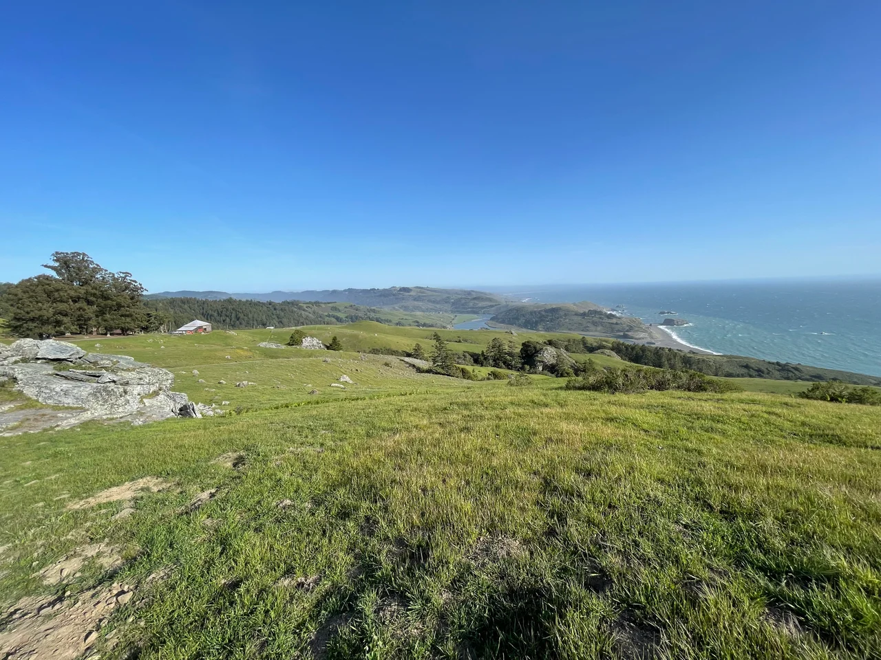
Prairie, Fog, and the Cathedral Tree
The preserve contains one of the largest remaining coastal prairies in Sonoma County -- 1,400 acres of grassland interspersed with redwood and Douglas fir forest, oak woodland, chaparral, and riparian corridors. The terrain rises sharply from near sea level to 2,090 feet, and the resulting microclimates are dramatic: fog banks settle on the lower slopes while the ridgelines bask in sunlight, sometimes separated by only a few hundred yards. Wildflower displays in wet years -- owl's clover, goldfields, cream cups, blue-eyed grass, purple needlegrass -- can approach what botanists call superblooms. In the shaded gullies and redwood understories, trillium, sorrel, orchids, and ferns thrive, and a remnant old-growth redwood known as the Cathedral Tree stands among them, a survivor from the forests that Russian colonists began logging in the early nineteenth century.
Highway of Wings
Jenner Headlands sits along the Pacific Flyway, and fall raptor migration is one of its defining spectacles. From Hawk's Hill -- a knoll along the trail system designated for viewing -- visitors watch red-tailed hawks, sharp-shinned hawks, peregrine falcons, northern harriers, osprey, and bald eagles ride thermal currents along the coast. Citizen scientists contribute to annual Hawk Watch counts, part of a broader monitoring partnership with Point Blue Conservation Science and the Cornell Lab of Ornithology. Grassland bird surveys in 2010 documented species absent from nearby state parklands, including Grasshopper Sparrow, Lark Sparrow, and Horned Lark, along with special-status species like Bryant's Savannah Sparrow. Forest monitoring in 2023-24 recorded 65 bird species and found that restoration projects had not reduced diversity -- a result that mattered, because land managers had worried that thinning forests for fire resilience might drive out the birds that depend on dense canopy.
Healing the Streams
Conservation at Jenner Headlands has been hands-on and sometimes controversial. In Russian Gulch, crews removed large woody debris barriers that had blocked fish passage for decades, reopening spawning habitat for steelhead trout and -- as the 2025 coho discovery proved -- endangered salmon. Rotational grazing infrastructure was upgraded in 2022 to maintain biodiversity in the coastal prairie without overgrazing. Vegetation management has targeted invasive plants and Sudden Oak Death, while shaded fuel breaks and prescribed fire projects address the wildfire risk that grows more urgent with every drought year. The bobcats, mountain lions, deer, red-bellied newts, slender salamanders, and western forest scorpions that inhabit the preserve share space with these restoration activities, which are carried out under CEQA guidelines designed to minimize disturbance to sensitive species.
Sea to Sky
Jenner Headlands opened to the public on September 7, 2018, after three years of trailhead construction. The entrance on Highway 1 includes parking, picnic tables, restrooms with a living roof, and interpretive kiosks. A short ADA-accessible trail leads to Sentinel Point, where a telescope overlooks the coast, Goat Rock, and the Russian River mouth. The main route, the four-mile Coastal Prairie Loop, traverses open grassland with unbroken Pacific views. For those seeking something more punishing, the Sea to Sky Trail climbs to the summit of Pole Mountain -- a 15-mile round trip with 3,600 feet of elevation gain that rewards with views stretching inland to Mount St. Helena and the Mayacamas Mountains. On clear days, Point Reyes is visible to the south. On foggy ones, the trail rises through cloud into sunlight, and the world below disappears.
From the Air
Coordinates: 38.470N, 123.133W. The preserve occupies the coastal hillsides immediately south of the Russian River mouth at Jenner. From the air, look for the broad coastal prairie rising steeply from Highway 1 toward ridgelines at 2,090 ft. Goat Rock and the sea stacks are visible at the coast below. Pole Mountain is the highest point in the preserve. Nearest airport: Charles M. Schulz-Sonoma County Airport (KSTS), approximately 30 nm southeast. Recommended altitude: 2,000-4,000 ft for full topographic perspective. Fog frequently blankets the lower slopes while ridgelines remain clear.
Nearby Stories
- Neon and Nostalgia at the Flamingo 4.9 km away
- Museum of the American Indian 8.7 km away
- The Swede on Cobb Mountain Road 11 km away
- Cordell Bank: The Invisible Island 15 km away
- The Sea Ranch 21 km away
- Pixieland 706 km away
- Neskowin Ghost Forest 744 km away
- ʻAkaka Falls State Park 3641 km away