Jose Rizal Memorial Protected Landscape
He bought the land with lottery winnings. In August 1892, just two months after arriving in Dapitan as a political exile, Jose Rizal pooled resources with the Spanish governor Ricardo Carnicero and a local Spaniard named Francisco Equilor to purchase a ticket in the Reales Loterias Espanolas de Filipinas. They won. Rizal used his share -- four thousand pesos -- to buy a sixteen-hectare estate in the seaside barangay of Talisay. On that land, the man the colonial government had banished to silence built a compound of bamboo and nipa houses, a school for boys, a hospital for the poor, a farm, and a water system. Today, the site covers 439 hectares and is one of the Philippines' most significant protected landscapes.
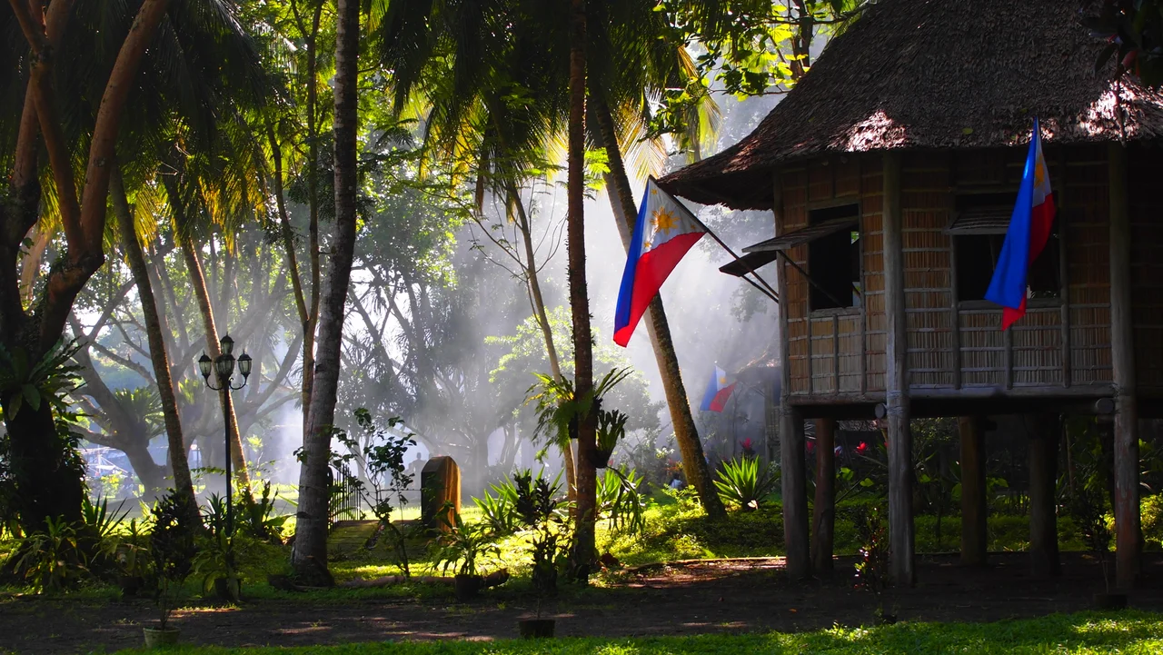
Five Houses and a Life
The compound that Rizal built on his Talisay estate tells you everything about how he chose to live his exile. The Casa Residencia, the largest structure, served as his home -- one bedroom, a surrounding veranda with views across Dapitan Bay. His mother and sisters stayed here during their visits from Calamba, Laguna. The Casa Redonda, an octagonal stilt house, doubled as student quarters and a clinic. The Casa Cuadrada, square-shaped and set at the base of a hill, functioned as a workshop and dormitory. Two small huts called the Casitas de Salud -- one for men, one for women -- perched atop a low hill to house patients who traveled from other towns. An outdoor kitchen, the Cocina, featured a traditional banggerahan scullery and a kalan, a firewood-fueled clay stove. Even the henhouse was distinctive: the Casa Redonda Pequena, a hexagonal shed. All five main structures have been reconstructed from bamboo and nipa palm, faithful to Rizal's original designs.
Doctor, Teacher, Engineer
Rizal's activities on this land went far beyond farming. He opened a school that educated local boys without charge. He built a hospital where he practiced medicine and treated the poor for free -- the same medical skill that had earlier won him the Talisay estate. He constructed a dam, an aqueduct, and a water reservoir, applying engineering principles to improve the community's infrastructure. On a large rock in the middle of the property -- known today as Mi Retiro Rock -- he sat and wrote poetry. Two poems from this period survive: "Mi Retiro" (My Retreat) and "Himno a Talisay" (Hymn to Talisay), reflections on exile that transform a punishment into something approaching peace. The Rizaliana Museum, built in 1971 near the park entrance, preserves his memorabilia, including the blackboard and table he used for teaching.
From Ten Hectares to Four Hundred
The protected area has grown substantially since Rizal's time. In 1940, President Manuel Luis Quezon signed Proclamation No. 616, establishing the Rizal National Park on an initial ten hectares. The designation formally recognized what Filipinos already knew: that this was hallowed ground. In 1973, President Ferdinand Marcos declared it a national shrine through Presidential Decree No. 105. Then, in 2000, the site's boundaries were dramatically expanded to 439 hectares, with a fifteen-hectare buffer zone, and it was reclassified as a protected landscape under the National Integrated Protected Areas System through Proclamation No. 279. That expansion acknowledged that the surrounding hills and coastline are integral to the landscape's character -- the same views of Dapitan Bay that Rizal saw from his veranda.
A Shrine on a Peninsula
The Jose Rizal Memorial Protected Landscape occupies a hilly peninsula facing Dapitan Bay in Zamboanga del Norte, about a kilometer northwest of the Dapitan city center. An amphitheater hosts cultural events, and the park's curator maintains an office near the entrance. The landscape is accessible from Dipolog Airport, roughly nine kilometers to the south, via the Dipolog-Oroquieta National Road and Jose Rizal Avenue -- a road that also leads to the Dakak Park and Beach Resort in Taguilon. For the millions of Filipinos who consider Rizal the embodiment of national aspiration, this place carries a weight that no guidebook can fully convey. It is where their hero was sent to be forgotten, and where he refused to be.
From the Air
The Jose Rizal Memorial Protected Landscape sits at approximately 8.67N, 123.42E on a hilly peninsula facing Dapitan Bay in Zamboanga del Norte, Mindanao. Dipolog Airport (RPMG) is approximately 9 km to the south. From the air, look for the peninsula jutting northwest from the Dapitan city center, with the reconstructed nipa houses visible at lower altitudes. The 439-hectare protected area covers the peninsula and surrounding hillsides. At 3,000-5,000 ft, the full extent of the protected landscape and its relationship to Dapitan Bay becomes clear.
Nearby Stories
- SS John Burke 15 km away
- Pamplona Massacre 49 km away
- 1995 Ipil Massacre 89 km away
- Japanese Cruiser Abukuma 90 km away
- 1955 Lanao Earthquake 98 km away
- November 2023 Mindanao Earthquake 334 km away
- Balut Island 394 km away
- Sinking of MV Sewol 2816 km away