Kamaran
For three months in 1513, Portuguese sailors starved on this island. They had goats and camels and little else, and something in the air - a fever that clotted the blood - was killing them one by one. Afonso de Albuquerque had come to Kamaran after a failed siege of Aden, and the island, flat and barren and ringed with coral, offered no welcome. Five hundred years later the boats have stopped coming and the mosques the Ottomans built are quiet, but Kamaran's strangest chapter lies between those bookends: a century when this forgotten rock became the world's busiest quarantine station, and the islanders prospered on the business of keeping pilgrims alive.
Empire After Empire
Kamaran is a shelf island, sitting in the shallow waters of the Arabian Peninsula's continental shelf, with coral reefs wrapping three of its sides. It is long and flat, with a few hills in the south, and its highest point, Jabal Yaman, tops out at just 24 meters. What Kamaran lacked in drama it made up for in position - the largest Yemeni island in the Red Sea, sitting close to the narrow southern neck where the Indian Ocean trade threads into the Mediterranean world. In 1523, Selman Reis sailed an Ottoman force of 4,000 men against the Portuguese garrison and swept them off the island entirely. The Ottomans held it for almost four centuries. They built a mosque, a garrison, and watched the dhows pass. Kamaran passed from Ottoman to British hands in June 1915, when the Empress of Russia landed an armed party on the evacuated island and the British governor of Aden quietly began administering a territory they never formally claimed.
The Quarantine Boom
The modern story of Kamaran began with pilgrimage. Every year hundreds of thousands of Muslims from British India, the Dutch East Indies, and beyond boarded ships bound for Mecca, and the authorities worried that each boat also carried cholera. Kamaran became the checkpoint. The British expanded what the Ottomans had left - long lines of barracks replaced wattle huts, big disinfecting plants processed pilgrims on production-line principles, a distillation plant turned seawater into drinking water. There was a power station, a wireless telegraph, a small railway hauling fuel, carpenters' shops, and a neat cantonment of officials' bungalows. In Kamaran village, fine houses and a magnificent mosque went up. Islanders sold bread, fruit, and prayer beads to pilgrims waiting out their cleansing. The population grew. For a people who had lived for centuries on fishing and pearl diving - the latter killing most men before fifty, according to Norman Lewis - the pilgrimage trade was an unaccustomed prosperity.
The Day Jeddah Cut the Cord
It ended in 1953. Saudi Arabia opened its own quarantine station at Jeddah and insisted that pilgrim ships bypass Kamaran. Almost overnight, the production line fell silent. The long lines of barracks emptied. The distillation plant was left to rust. A handful of caretakers kept watch over the buildings while bureaucracies in London and Aden debated their disposal. The fine houses stayed, but the trade that had paid for them was gone, and the mosque of Kamaran became, again, what it had always been at heart - a local place of prayer, stripped of its role in a global religious economy. The pearl divers were already dying young. The pilgrim ships were no longer stopping. The British lingered on Kamaran as absent landlords, issuing stamps and collecting customs, until decolonization came for them too.
An Island Passed Between Yemens
On November 30, 1967, the British walked out of Aden and Kamaran became part of the People's Democratic Republic of Yemen - South Yemen. The northern and southern Yemens had different sponsors, different ideologies, different visions of Arab statehood. In 1972, the Yemen Arab Republic - North Yemen - seized Kamaran from South Yemen by force. The island's 2,200 residents, who had outlasted Portuguese fevers, Ottoman garrisons, British administrators, and pearl-diving quotas, now had a new set of authorities to navigate. Yemen was formally unified in 1990, and Kamaran became part of the Republic of Yemen, a country that in the decades since has endured its own civil wars and a devastating conflict that has cut off most of its islands from the world.
What the Corals Remember
Today Kamaran is quiet. The coral reefs still wrap the island on three sides, teeming with the fish that keep the small fishing fleet in business. The population has changed little. The buildings the British put up - the old Commissioner's office, the Ottoman mosque, the shade of a few administrative structures - are aging in salt air and sun. Nigel Groom called his 1954 account of Kamaran The Island of Two Moons, a reference to a local tradition that you can see the moon twice from the island's curve. Whether or not the moons are real, the layering is: Portuguese fever, Ottoman mosque, British quarantine, Yemeni revolution, all on a flat shelf in the southern Red Sea where the coral still grows faster than the buildings fall.
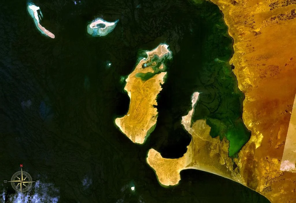
From the Air
Kamaran lies at 15.35°N, 42.59°E, in the southern Red Sea approximately 3 km off the Yemeni coast near Al-Hudaydah Governorate. From 6,000-10,000 feet AGL the island's long narrow shape is distinctive - it is flat with coral reefs visible through clear water on three sides. The southeastern cape of Ra's al Yaman and the nearby 24-meter Jabal Yaman are the highest points. Nearest airport is Hodeidah (OYHD / HOD) about 80 km southeast. Note: Yemeni airspace has significant security restrictions; verify access.
Nearby Stories
- 2025 Israeli attacks in Yemen 38 km away
- Italian Submarine Guglielmotti (1938) 43 km away
- Attacks on the Sounion 59 km away
- Battle of Port Midi 74 km away
- Battle of Amran 74 km away
- Battle of Sanaa (2017) 102 km away
- Zafar, Yemen 160 km away
- Southern Red Sea region 196 km away