.jpg)
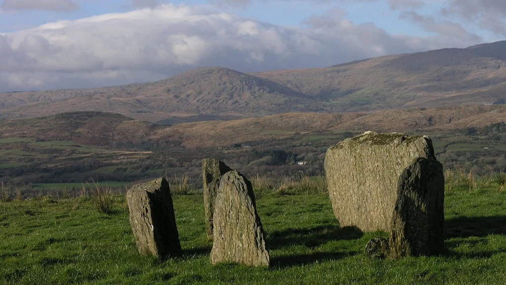
Kealkill stone circle
When archaeologists excavated this hillside ring in 1938, they got the orientation wrong. They thought the large stone on the north side of the circle was the axial one - the recumbent slab that anchored the whole geometry. It made sense at the time. The big stone looked like it should matter most. But Cork-Kerry circles point southwest, toward midwinter sunset, and forty-six years later, in 1984, the archaeologist Sean O Nuallain re-examined Kealkill and decided that the small, almost insignificant stone slab to the southwest was actually the axial. The big one to the north had been the loudest object in the field, but it was not the one the builders had cared about most.
Five Stones and Two Giants
Kealkill is an axial five-stone circle of the type found across counties Cork and Kerry. Five low stones form an elliptical D-shape, with the axial stone at the southwest end. The portal stones - the entrance markers, opposite the axial - are both around 1.2 metres tall but very different in width: one a metre wide, the other half that. The axial slab itself is only 0.76 metres high, much smaller than the impressive stone to the north that confused the original excavators. Five metres to the northeast of the ring, two tall standing stones rise from the hillside. The shorter and broader one is 2.3 metres tall. The taller was originally 5.3 metres - more than 17 feet - until at some point, presumably blown over in a gale, it cracked and fell. The 1938 excavators set the longer broken piece upright again, discarding the stump in the ground. It now stands 4.3 metres. Two metres further on is a ring cairn, originally girdled by 18 radially-arranged kerb stones.
From Aberdeenshire to West Cork
In 1909, when the type was first named, these monuments were called recumbent stone circles - after the very similar rings of Aberdeenshire in Scotland, where one stone always lay lengthways at the southwest end. The Irish examples in Cork and Kerry shared that recumbent geometry. For most of the twentieth century, the two traditions were treated as related cousins. In 1975, however, Sean O Nuallain looked at the differences between them carefully enough to argue that the Irish rings deserved their own name. He proposed Cork-Kerry stone circles, and renamed the crucial stone the axial stone rather than the recumbent. The change was more than terminological. It reflected a recognition that Bronze Age people across northwestern Europe had developed similar but locally distinct traditions of stone-setting, each shaped by its own community's understanding of what the sky and the land required.
What the Hillside Holds
The circle sits on the slopes of Maughanclea Hill at about 400 feet, overlooking Bantry Bay. On a clear day, Breeny More stone circle is visible to the southwest. The ground here would have been suitable for cultivation in the Bronze Age, though why this particular spot was chosen for ceremonial use rather than for crops remains unanswered. The 1938 excavation found two shallow ditches crossing near the centre of the ring, in the acid peat. They were interpreted as holding wooden beams that supported a vertical post - which, if true, would make Kealkill unique among Cork-Kerry circles. The cairn nearby gave up nothing useful for dating: no grave goods, no bones, no charcoal that could be pinned to a particular century. What is here is what was here when the builders left - the stones, the alignment, the southwest sight-line. Standing in the ring on a winter afternoon, with Bantry Bay opening below and Maughanclea rising behind, the orientation toward midwinter sunset has a quiet logic. The shortest day, at the lowest light: the moment marked here, three or four thousand years ago, by people who do not appear in any written record we possess.
From the Air
Kealkill stone circle sits at 51.745 degrees north, 9.371 degrees west, on the slopes of Maughanclea Hill at about 400 feet elevation, just outside Kealkill village in County Cork. From the air, the circle is too small to see, but Maughanclea Hill rises distinctly above the head of Bantry Bay, with Kealkill village at its foot. The view southwest from the site takes in Bantry Bay; Breeny More stone circle is visible from the ground in that direction. Nearest international airport is Cork (EICK), about 70 km east; Kerry (EIKY) lies to the northwest. The Caha Mountains rise to the northwest beyond the bay.
Nearby Stories
- Cloghan Castle, Lough Hyne 1.2 km away
- Headford Ambush 2.2 km away
- Caragh Lake 2.6 km away
- Bandon, County Cork 3.9 km away
- Ardgroom 4.6 km away
- Horse Racing in Ireland 13 km away
- The Sinking of the Lusitania: The Torpedo That Changed the War 20 km away
- HMHS Llandovery Castle 23 km away