
Kittelfjäll
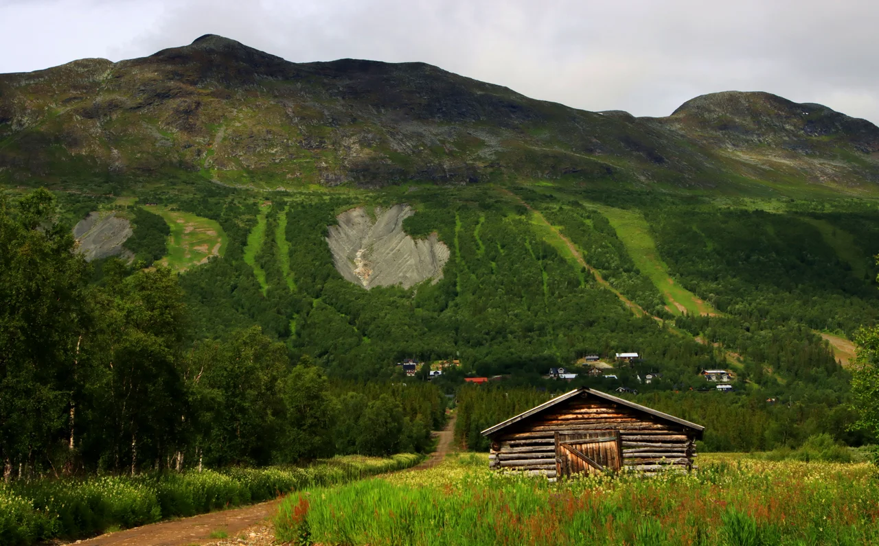
The deepest gully on Kittelfjället's southeastern face was cut in a single event. In 1909 a mass of waterlogged moraine let go and slid, gouging a channel straight down through the loose glacial debris that blankets the slope. More than a century later, skiers point their tips into that gully every winter and call it a run. The mountain has not finished: several of these ravines are still active, shedding landslides and mudflows when the thaw comes. The terrain that draws people to this corner of Swedish Lapland is, quite literally, a record of collapse.
Runs the Mountain Cut Itself
Kittelfjället tops out at 1,225 metres, and a ridge walk links its two summits — 1,217 metres to the south, 1,231 to the north — with the valley of Vojmådalen unrolling below and Girifjället and Marsfjället standing off in the haze. The ski area occupies the southeastern flank, and its character is unusual: of roughly forty-two marked descents, only a handful are groomed. The rest are natural features, the ravines and rolling ridges the ice and the landslides left behind, threaded with sparse mountain birch. Snow here falls dry and light, and wind redistributes it so unevenly that depth can change by metres between one gully and the next. Lifts run to a summit lodge. Below them sit the tame things a resort needs — a terrain park called Central Park, a beginners' zone where children learn balance — and above them, climbers and paragliders work the steeper faces. On the Kittelsjöarna lakes, snowkiters use the same wind that ruins the snowpack.
Överste Lasse
Long before any of this had a lift ticket, the Southern Sámi knew the place as Stoere Giemnie, or Tjiehtele. The crown knew it differently. A site inspection went up the valley in the summer of 1814, and on 22 August 1815 the county authorities granted a homestead to Lars Larsson of Dalarna, sweetened with a thirty-year exemption from tax. Larsson had not waited for the paperwork — he and his wife, Anna Gustafsdotter of Brindroset, had already put up a one-room cottage and a small barn below Kittelfjällsskalet. His neighbours lived at Tresund, impossibly far; when a settler reached Dikanäs in 1815, that counted as company at twenty-five kilometres. The parish nicknamed him Överste Lasse, uppermost Lasse, because nobody lived further out. The land was generous with grass, the lakes with fish, the slopes with ptarmigan through the winter. Larsson drowned on 31 May 1828. Anna took the homestead rights, then signed them over to their children; by 1851 three farmers held the ground between them.
Lime, Serpentine, and a Breakthrough Valley
The river doing the shaping is the Vojmån, a headwater of the Ångerman system whose upper reaches remain undammed and legally protected — a rarity in a region whose rivers were largely converted to electricity in the last century. It runs between Kittelfjället and Borkafjället through one of the most pronounced breakthrough valleys in Sweden, a trench cut clean across the grain of the mountains. Borkafjället reaches 1,310 metres and stands some 800 above the surface of Lake Borka, its cliffs skirted with talus. Botanists come for the chemistry. Lime-rich ground supports mountain avens, green spleenwort, hair sedge, alpine chickweed and net-leaved willow, while the lime-shunning parsley fern somehow persists among them. South of the river, serpentine hills produce something stranger still: pine forest that grows thin, low and stunted on soil most plants cannot tolerate. Anglers ignore all of it and fish for grayling and heavy trout.
Sixty-Three Residents, Fourteen Hundred Cabins
As of 2023, sixty-three people lived here permanently. Around them stand roughly 1,400 privately owned properties and some 700 commercial beds — a village that inflates and deflates with the seasons like a lung. Statistics Sweden briefly classified Kittelfjäll a small locality between 2015 and 2020, then stopped. What the place has instead is infrastructure that punches far above sixty-three people. In 2022 Coop Nord took over the grocery store Handlar'n and doubled it to 334 square metres, spending 6.4 million kronor on fixtures and rigging the shop so customers can buy food when nobody is working. The snowmobile association, founded in 2006, maintains 260 kilometres of trail with two grooming machines and five snowmobiles. The Övre Vojmådalen community association runs a summer café selling coffee and waffles, organises the Midsummer celebration and the flea market, and rents out the hall and the sauna.
Minus Forty-One Point Seven
The nearby Gielas A weather station logged −41.7 °C in January 2024 and 28.7 °C in July 2018, a seventy-degree swing recorded within a single decade. Wind above 20 metres per second is ordinary; in 2017 a gust of 47 was measured here. Rain arrives in bursts rather than drizzle — 66.2 millimetres fell on 24 July 2009, still the local record, and the 44 millimetres of 2 August 2023 was enough to lead the whole of Vilhelmina Municipality for the year. Children raised in this valley grow up reading weather the way other people read traffic. One of them, Bengt-Erik Grahn, born in Dikanäs down the road in 1941, became Sweden's finest slalom racer of the 1960s and took six national championships during that decade before his death in 2019.
From the Air
Kittelfjäll sits at 65.255°N, 15.527°E in the Vojmådalen valley of Västerbotten County, roughly 90 km northwest of Vilhelmina. Kittelfjället rises to 1,225 m (about 4,020 ft) immediately northwest of the village, with Borkafjället at 1,310 m (4,300 ft) beyond it — both are unmistakable from the air, the former scored with deep parallel ravines on its southeastern face. A viewing altitude of 6,000–8,000 ft MSL keeps you above the summits with terrain still legible below. The valley itself, and the long thread of the Vojmån running east through it, is the surest navigational line. Nearest fields: Vilhelmina (ESNV, elev. 350 m) about 50 nm southeast, Hemavan (ESUT, elev. 458 m) about 35 nm northwest, and Storuman (ESUD, elev. 279 m) further east. Expect strong, gusty mountain wind — surface gusts here have been recorded at 47 m/s — plus rapid subarctic weather changes, low winter light, and long polar-summer daylight.
Nearby Stories
- Hemavan 28 km away
- Storuman (lake) 29 km away
- Ranseren 37 km away
- Vindelfjällen Nature Reserve 40 km away
- Ammarnäs 44 km away
- Stora Blåsjön 54 km away
- Lapplandsleden 88 km away
- Namsvatnet 97 km away