
Stora Blåsjön
In 1971, about twenty people in a village that had never held more than two hundred stopped eating. There was no employer to strike against, and that was precisely the grievance: a copper orebody lay under the Stekenjokk plateau a short drive up the road, and nobody had come to dig it. Meanwhile the young people of Frostviken were leaving for the coast. So Stora Blåsjön went on hunger strike against an absence. Sweden noticed. Forty years later the village threw a party to mark the anniversary.
The Argument That Worked
Hunger strikes usually fail. This one did not. Mining began at Stekenjokk in 1976, and for a dozen years copper came out of one of the bleakest workplaces in the country — a plateau where the road tops out at 876 metres and the weather station recorded Sweden's coldest readings of 2007. The mine closed in 1988. The shafts are still visible from the road, and a memorial stone marks the years it ran. Applications to reopen have been filed since, and refused; the county authorities on both the Jämtland and Västerbotten sides have opposed them, and the Sami communities whose reindeer graze Stekenjokk each summer have been clear about what a new mine would cost their pastures. Blåsjön won its argument, held the prize for twelve years, then had to live with the ending.
A Farmhand and a Settler's Son
Two men founded the place in 1799 — a farmhand who came over from Norway, whose border sits six kilometres west, and a settler's son from Jormvattnet down the valley. What drew them was land nobody else wanted: a shore at the head of a long lake, some 280 kilometres north of Östersund, where the growing season is brief and the winter is not. The population peaked in the 1950s at roughly two hundred. By July 2010 it stood at seventy-eight. That curve, more than any single event, is the twentieth-century history of inland Norrland, and it explains why twenty people were prepared to go hungry over a hole in the ground.
The Road That Shuts
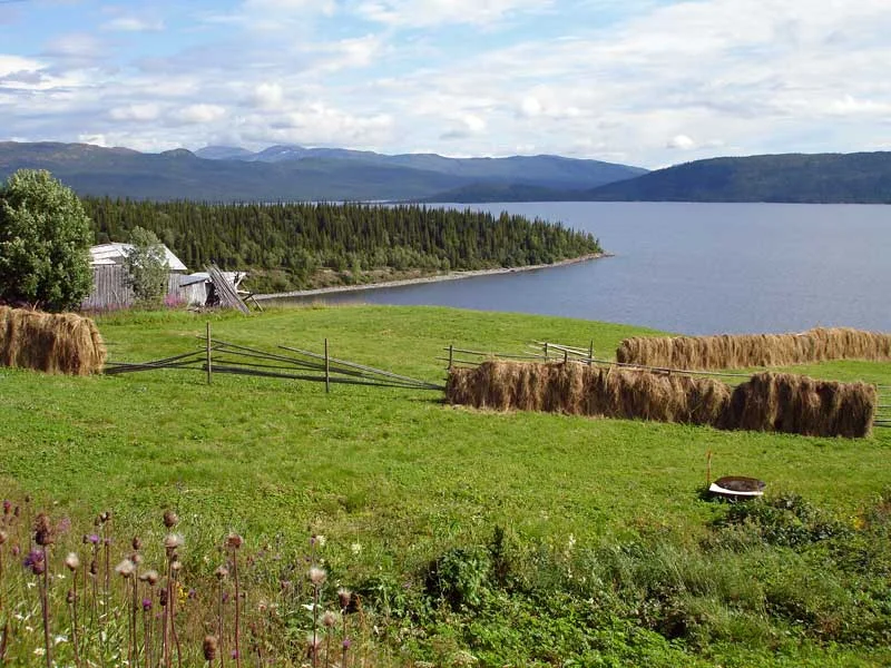
Vildmarksvägen, the Wilderness Way, runs 360 kilometres from Strömsund up through Gäddede, Jormvattnet and Stora Blåsjön, over Stekenjokk, then down to Klimpfjäll and Vilhelmina. Drivers arriving from the north meet the water before the houses, with the mountain Mesklumpen standing over the far shore and doubled in it. Long stretches run above the treeline. The Stekenjokk section closes from mid-October until the first week of June, because keeping it open would be pointless: when Cyclone Hilde crossed in November 2013, the plateau station clocked average wind speeds of 47 metres per second, with gusts up to 56. For four months of the year the road brings a steady traffic of campers and motorcycles. For the other eight, Blåsjön sits at the end of a dead end.
Six Kilometres of Marble
Somewhere between Stora Blåsjön and Ankarvattnet, beneath the same road, lies Korallgrottan — the Coral Cave, the longest in Sweden. Six kilometres have been surveyed since its discovery in 1985, and it is cut through marble rather than the limestone that hosts most large cave systems. Nobody enters without a guide. Above ground, the road passes Brakkåfallet, one of several falls on the run down toward Jorm, and crosses country holding the densest brown bear population in the country. The lake itself divides into Stora and Lilla Blåsjön, fed by the Ankarälven and the Lejarälven. Its outflow, the Blåsjöälven, is routed through an underground waterway to the generating station at Blåsjöfallet before the water is finally released into Stor-Jorm.
Hilda, Herbert and the Second Population
In the middle of the village there is a moose farm. Mountain Moose runs guided visits to a small family herd headed by two animals named Hilda and Herbert, and it is exactly the sort of enterprise a community of seventy-eight invents in order to keep existing. There is also a shop, a filling station, a restaurant, a café, a hairdresser, and a museum in the old schoolhouse. The lake has a reputation for outsized trout, and Arctic char share the water with them. Skiing is done on Mesklumpen, on a lift-served hill with a long fall for somewhere so far from any resort town. At Easter, through the sports holidays, and across the summer the cabins fill and the village more than doubles. Then the plateau road shuts, the visitors go home, and Blåsjön returns to being seventy-odd people at the end of the line.
From the Air
Stora Blåsjön sits at 64.837°N, 14.083°E in northern Jämtland, roughly 6 km east of the Norwegian border. The lake is the primary visual landmark — a long, narrow, two-lobed body of water aligned roughly north–south with the mountain Mesklumpen on its flank; the treeless Stekenjokk plateau to the northeast rises to about 876 metres at the road's high point and holds snow into June. Recommended viewing altitude 4,000–6,000 ft AGL for the lake-and-mountain composition, higher to take in the Stekenjokk plateau and the Norwegian peaks of Børgefjell to the northwest. Nearest airports: Vilhelmina South Lapland (ESNV) about 100 km east, Hemavan Tärnaby (ESUT) to the northeast, and Mosjøen Airport, Kjærstad (ENMS) on the Norwegian coast to the west; Östersund Åre (ESNZ) is the nearest major field. Expect rapid mountain weather: this plateau recorded 47 m/s average winds (56 m/s gusts) in November 2013 and Sweden's coldest readings of 2007. Low cloud and icing are common outside high summer.
Nearby Stories
- Limingen 6.1 km away
- Jetnamsklumpen 10 km away
- Majavatn 21 km away
- Kittelfjäll 43 km away
- Matsdal 82 km away
- Lapplandsleden 84 km away
- Wideroe Flight 744 96 km away
- Namsos Campaign 131 km away