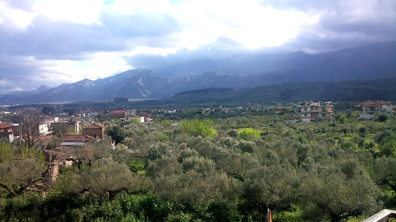

Kladas
The village is named after Krokodeilos Kladas, a fifteenth-century Greek military commander who led resistance against Ottoman rule in the Peloponnese — not quite the kind of name you'd expect for a farming village of 430 people on the northern outskirts of Sparta. But Kladas is that kind of place: modest in scale, grounded in history, and quietly going about its business between two mountain ranges while the ancient reputation of the city it borders does most of the talking.
Between Two Mountains
Kladas sits at 240 meters above sea level in the Eurotas valley, squeezed gently between Mount Taygetos to the west and Mount Parnonas to the east. The position moderates the climate: Mediterranean and temperate, averaging 19 degrees Celsius annually with about 600 millimeters of rain. Fog and ice arrive in autumn and winter, though serious snowstorms are rare and seldom last more than four days. The village became an official community on 31 August 1912, formalized under the self-government plan that Greece's first modern governor, Ioannis Kapodistrias, had laid out nearly a century earlier. In 1997, the community was incorporated into the extended municipality of Sparta. The road connecting Athens to Sparta now passes through, making Kladas a crossroads for travelers heading south toward Sparti, or eastward toward the islands of Elafonisos and Kythera.
Olives, Bicycles, and Biological Certification
Most residents of Kladas work the land or keep animals. Olive cultivation dominates the surrounding fields, with additional crops of tomatoes, pumpkins, and kitchen-garden vegetables. Some local production now holds EU organic certification — a qualification the village takes seriously enough that the article comparing its standards to those of the Netherlands reads less like boosterism than a straightforward statement of fact. Alongside the agricultural life, residents have gradually shifted toward cycling for local transport, reducing automobile noise in a village that has no commercial shops. The village does have two coffee shops, a combined coffee shop and tavern, and a restaurant on the main national road for travelers. An olive-product packing factory rounds out the local economy. The broadband upgrade of recent years and the extension of Sparta's sewerage network — enabled by the opening of the Technological Educational Institute of Sparta on a hill above the village in 2005–2006 — have brought infrastructure into pace with the village's ambitions.
The Name Behind the Village
Krokodeilos Kladas was a real figure: a Greek military commander active in the late fifteenth century who organized armed resistance against Ottoman forces in the southern Peloponnese following the fall of Constantinople in 1453. He operated in the Mani region and Laconia, and his name — unusual enough to fix in memory — passed to this small community on the Spartan plain. Villages across Greece were renamed, regrouped, and reorganized through the nineteenth and twentieth centuries, and Kladas followed that pattern: formalized in 1912, absorbed into the Sparta municipality in 1997. The elementary school now serves only third and fourth graders; the others travel to neighboring Aphision and Kokkinorachi by state-funded bus. The junior and senior high schools are in Sparta proper.
A Crossroads Village in the Spartan Plain
Kladas sits at 37.108°N, 22.430°E, on the national road that connects Athens with Sparta — which means it is the first village travelers enter when approaching Sparta from the north, and the last one they pass through heading toward the capital. The Eurotas valley is broad and flat here, with the long escarpment of Taygetos visible to the west and Parnonas rising more gradually to the east. From altitude, the two mountain ranges frame the plain like canyon walls, with Kladas and modern Sparta visible as clusters of white buildings on the valley floor. The nearest airport is LGKL (Kalamata International), approximately 50 kilometers to the west-southwest across the Taygetos range. There is no instrument approach to the Spartan plain itself; the mountains on both sides require visual navigation at low altitude.
From the Air
Kladas is at 37.108°N, 22.430°E on the northern approach to Sparta along the Athens-Sparti national road. The Eurotas valley is broad and flat here, flanked by Taygetos (west) and Parnonas (east). Nearest airport: LGKL (Kalamata International), approximately 50 km west-southwest. Low-altitude VFR flight along the valley offers excellent views of the Spartan plain. Afternoon thermals off Taygetos are common in summer.
Nearby Stories
- Leonidio 1.4 km away
- Araklovon Castle 5.3 km away
- Battle of Valtetsi 5.3 km away
- Kardamyli 8.7 km away
- Pylos 8.9 km away
- Barony of Gritzena 9.7 km away
- Metamorfosi, Laconia 13 km away
- Arkadiko Bridge 19 km away