_(cropped).jpg)
Islands That Refuse to Hold Still
Count the islands and you get a different answer depending on when you ask. Before August 1883, there was one large island -- Krakatoa -- flanked by two smaller neighbors. After August 1883, two-thirds of the main island was gone, two new islands had briefly appeared, and the map of the Sunda Strait had been redrawn overnight. By 1885 those new islands had vanished. By 1930, another had risen from the caldera. By 2018, that island had collapsed and immediately started rebuilding. The Krakatoa archipelago is not a fixed place. It is a geological argument between creation and destruction, played out across four small uninhabited islands in the strait between Java and Sumatra, where the Indo-Australian Plate grinds beneath the Eurasian Plate and the earth buckles upward in fire.
The Survivors and the Lost
Today the archipelago consists of four main islands, arranged like points on a rough compass. Rakata, the largest, anchors the south -- the surviving half of old Krakatoa, its northern face sheared into a vertical cliff that exposes the volcano's layered interior. To the northwest sits Verlaten, known locally as Sertung, a low island with a central hill that emerged from the 1883 eruption relatively unscathed. It actually grew to nearly three times its pre-eruption area as pumice rained down, though waves eroded most of the gain within years. A spit of land extended to the northeast, cradling a brackish lake that became a haven for waterfowl before the sea eventually breached it. To the northeast lies Lang, also called Panjang or Rakata Kecil -- hilly, compact, and similarly expanded by pumice before contracting back. And in the center, occupying the caldera left by the 1883 collapse, sits Anak Krakatau, the volatile young island that has been the archipelago's center of attention since 1930.
Ghost Islands
The Krakatoa archipelago has a roster of the departed. Poolsche Hoed -- Dutch for "Polish Hat" -- was a small rocky islet that sat between the main island and Lang before 1883. Its name came from its silhouette as seen from passing ships: a sharp angular point that reminded Dutch sailors of the peaked caps worn by Poles. The eruption erased it entirely. More poignant are Steers and Calmeyer, two temporary islands born from the eruption itself. Volcanic debris piled up in the shallow Sebesi Channel north of Krakatoa, creating new landmasses almost overnight. Calmeyer rose to about 6.5 meters; Steers, slightly larger in area, never exceeded three meters above the waterline. When Rogier Verbeek visited in October 1883, Calmeyer had already fractured into half a dozen shrinking islets. Within two years, both islands had been ground to nothing by wave action. Sandbanks bearing their names persist on nautical charts -- monuments to islands that existed for barely a season.
Built on Borrowed Ground
Anak Krakatau's story is the archipelago's most dramatic chapter, a cycle of creation and collapse compressed into a single century. The island first broke the surface in December 1927, a dome of volcanic rock pushing up from the submerged caldera floor. Waves flattened it within days. Two successor islands met the same fate. The fourth attempt, beginning in August 1930, finally produced lava flows faster than the sea could erode them. For nearly nine decades, Anak Krakatau grew steadily, gaining 7 to 9 meters of elevation per year and reaching a peak of 338 meters by September 2018. Three months later, on December 22, its southwestern flank collapsed into the strait. Waves up to five meters high devastated communities along 300 kilometers of coastline. The death toll reached 437. The island lost two-thirds of its volume in a single event -- an uncanny echo of what happened to its parent 135 years earlier. Within weeks, fresh eruptions were rebuilding the shattered cone.
A National Park on Unstable Ground
Administratively, the entire Krakatoa archipelago falls within Lampung province and is part of Ujung Kulon National Park, the Javan rhinoceros sanctuary on the western tip of Java. The designation places some of the most violently active geology on Earth inside a conservation framework -- a contradiction that nature cheerfully ignores. The archipelago sits on the far western rim of the Pacific Ring of Fire, at a point where the island arc system bends and the crust may be unusually thin. Collapse of an older volcanic edifice, possibly in 416 or 535 CE, formed a seven-kilometer-wide caldera whose remnants became Verlaten and Lang. The Rakata, Danan, and Perboewatan cones grew within and atop those ruins, coalescing into the pre-1883 island of Krakatoa. Each generation of geology is built on the wreckage of the last. The islands are monuments to impermanence, landscapes whose only constant is change.
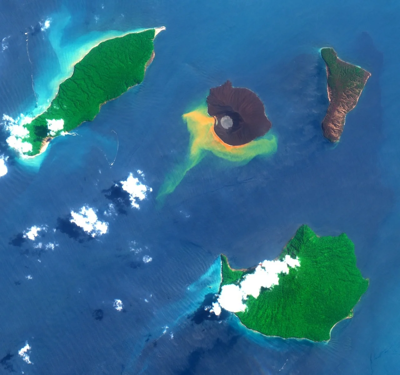
Reading the Ring from Above
From altitude, the archipelago reveals its geometry with startling clarity. The three older islands -- Rakata, Verlaten, and Lang -- curve around the caldera like fragments of a broken ring, remnants of an older, larger landmass. In the center, Anak Krakatau's dark cone trails a plume of steam or ash, depending on its mood. The shallow waters of the caldera shift color between blue and milky green where volcanic gases seep from the seafloor. On clear days, the entire structure is legible: the arc of destruction, the stub of Rakata's cliff, the low profiles of the flanking islands, and the stubborn new cone rising from the gap. The strait itself narrows here to about 30 kilometers between Java and Sumatra, and the archipelago sits almost exactly in its center. Sailors and pilots have used it as a waypoint for centuries. It is hard to miss -- a cluster of islands that the earth keeps revising, draft after draft, with no final version in sight.
From the Air
The Krakatoa archipelago is centered at approximately 6.10S, 105.42E in the Sunda Strait between Java and Sumatra. The four main islands -- Rakata (south), Verlaten/Sertung (northwest), Lang/Panjang (northeast), and Anak Krakatau (center) -- form a recognizable ring pattern around the 1883 caldera. Nearest airports: Soekarno-Hatta International (WIII) ~150 km NE, Radin Inten II (WICT) ~80 km NW. The archipelago is part of Ujung Kulon National Park. Best viewed from 8,000-15,000 feet for the full caldera geometry. Active volcanic area; Anak Krakatau frequently produces steam/ash plumes. Check NOTAMs for volcanic ash advisories.
Nearby Stories
- When the Earth Swallowed Batavia 10 km away
- Where Tigers Return and Addicts Heal 29 km away
- Ujung Kulon National Park 47 km away
- 1933 Sumatra Earthquake 86 km away
- The King's Footprints in the River 99 km away
- Surfing in Indonesia 115 km away
- Lion Air Flight 610 144 km away
- Sainte-Rose, Réunion 5514 km away