La Unión, Huánuco
La Unión got its name by act of law. On February 5, 1875, the Peruvian government formally united two towns on opposite banks of the Vizcarra River - Aguamiro, the textile center, and Ripán, whose Quechua name means small with an affirming suffix - into a single municipality. They did not actually merge. Aguamiro became the seat of the La Unión district; Ripán kept its own district capital status across the water. Two bridges connect them. Above everything, eight kilometers up a dirt road, lie the ruins of Huánuco Pampa - the Inca provincial capital whose abandoned plateau gives La Unión its deepest historical context.
Aguamiro, the Textile Factory
The Quechua word aguamiro means textile factory, and that is what this place was for centuries before Peru became Peru. Under the Inca, the mitmakuna - communities relocated by imperial decree to serve the state's economic needs - were settled here to produce cloth. They fed the resource network that made Huánuco Pampa, the provincial capital just above, function as one of the empire's major administrative centers. After the Spanish arrived, the textile tradition continued. Colonial obrajes - large workshops that were often closer to forced-labor enterprises than factories - turned out cloth using indigenous workers through the worst of the colonial period. The looms are quiet now. The word survives. The town still carries the memory of having been, for a very long time, a place that made things out of thread.
Two Bridges
The Vizcarra River splits La Unión in half, and the two bridges across it tell a small engineering history of the town. The older one, called Cáceres, is stone masonry, used now only for foot traffic and bicycles. The newer one - called the Union Bridge with appropriate symbolism - is built of steel with a wood decking, and carries the buses, trucks, and mototaxis that keep the town supplied. Standing on either bridge, you look up at the plateau that holds Huánuco Pampa to the east, and west toward the villages of Anchacgrande, Quchapampa, and Liriopampa in the Ripán district. The river's north-south flow shapes the town - elongated along the banks, narrow across, the way settlements tend to be when a valley dictates their plan.
The Plateau and the Plaza
Huánuco Pampa sits on the meseta above La Unión at around 3,700 meters. It is the largest Inca provincial capital ever excavated, a city of 4,000 buildings arranged around one of the most enormous plazas in the Andean world. The dirt road from La Unión climbs to the site in an hour or so; the walking route up the valley of Markaraqra takes longer but delivers you onto the plateau the way the Inca laborers would have arrived. From the viewpoint atop Cerro San Cristóbal back in town you can see the relationship between the two - the colonial town below, the pre-Columbian capital above, the valley stitching them together. La Unión is one of very few provincial towns that sits in direct dialogue with an Inca administrative center of this scale.
The Fiesta del Sol
Late July brings La Fiesta del Sol - the Festival of the Sun - the town's most important celebration. The name nods toward Inti Raymi, the Inca solar festival traditionally observed on the winter solstice. Modern celebrations blend Catholic and pre-Columbian elements: processions, music, costumed dancers, shared meals in the plaza. Local families make and mend traditional clothing for everyday wear and for festivals, and the fiesta is when the best pieces appear. La Unión's altitude - 3,204 meters - and its cool dry winter make late July a striking time for the celebration: clear skies, sharp sun, cold shadows, and the Markaraqra valley lit up during the day, then falling silent at night when temperatures drop well below the daytime high.
Cuñuq and the Road to Everywhere
The road to La Unión is a challenge. From Lima, you take the Panamericana north to Paramonga, then turn inland through a sequence of villages - Chaskitampu, Cajacay, Qunuqucha, Wallanka - with the pavement running out somewhere before La Unión. At the end of the drive is a narrow low semi-tunnel called Huajtahuaro, known locally as the Cave of the Cat for a local legend, a challenge for any bus driver. For a town the size of La Unión, the road network is remarkably far-reaching because of its geography: it connects to Chiquián and Huaraz in Ancash over the Yanashallash pass, to Huánuco city, and to its surrounding districts (Sillapata, Pachas, Yanas, Marias). Two kilometers away, the thermal baths of Cuñuq offer hot water in the Ripán district - a good way to close the day when the cold comes down the valley.
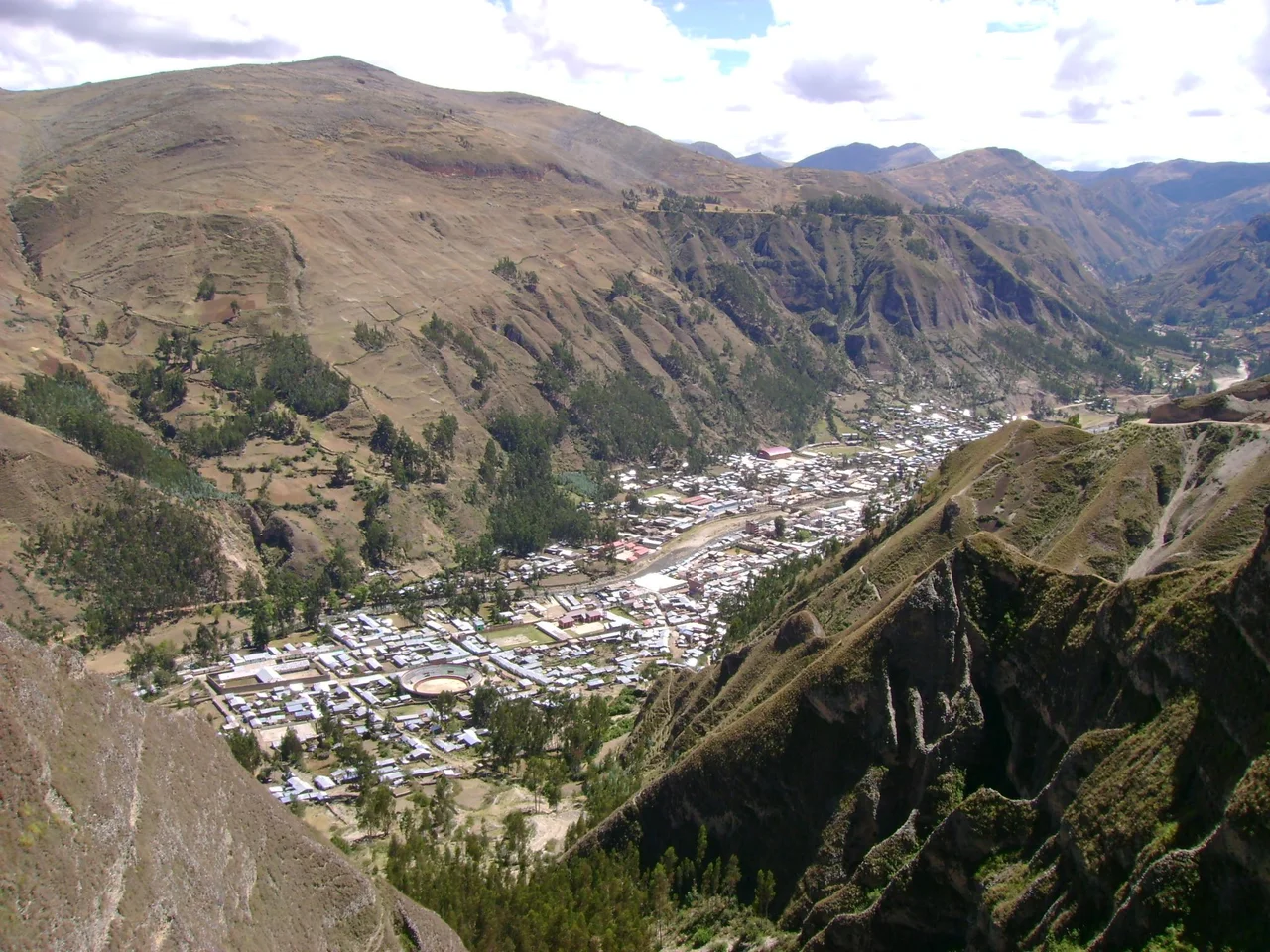
From the Air
La Unión is at 9.82°S, 76.80°W in central Peru, in the Vizcarra River valley at 3,204 meters. Huánuco Pampa (Wanuku Marka), the major Inca archaeological site, is on the plateau 8 km east-northeast of the town at roughly 3,625 meters. From altitude, look for the narrow green river valley running north-south, the two bridges across it near the town, and the geometric shadow of Huánuco Pampa's immense plaza on the high grassland above. The nearest airport is Alférez FAP David Figueroa Fernandini (HUU/SPHU) at Huánuco city, about 90 km east via mountain roads. Lima's Jorge Chávez International (SPJC) is 280 km west. Expect dramatic terrain - peaks above 4,500 meters - and the best visibility May through September.
Nearby Stories
- Lake Palcacocha 11 km away
- Huánuco 20 km away
- Huaraz 32 km away
- Inca Civil War 33 km away
- Raura Mountain Range 49 km away
- Huaricanga 69 km away
- Mantaro River 100 km away
- Huacrachuco 105 km away