
Las (Greece)
Homer wrote the name down, and it has not been forgotten since. Las — also called Laas, also called La — appears in the Catalogue of Ships in the *Iliad*, a brief listing that confirms the town existed in the Bronze Age imagination if not necessarily as described. By the time the geographer Pseudo-Scylax compiled his coastal survey around 330 BC, Las was real enough to be the only town he named between Cape Matapan, the southernmost tip of the Mani Peninsula, and Gytheio to the north. That stretch of Laconian coastline is dramatic and remote even today. Las occupied a place within it that mattered enough to fight over across more than two thousand years.
Between Three Mountains
When the traveler Pausanias visited in the 2nd century CE, Las was already fading. He described a town lying in a hollow between three mountains named Asia, Ilium, and Cnacadium — the old town itself stood on the summit of Mt. Asia, and the name 'Las' originally signified a rock at that original location. Ten stadia from the sea, forty stadia from Gytheio.
Pausanias found ruins. Before the walls he saw a statue of Heracles, and a trophy commemorating a Laconian victory over Macedonian soldiers from Philip V's army when he invaded Laconia. Among the ruins was a statue of Athena Asia. Near a fountain called Galaco — named for the milky color of its water — stood a gymnasium with an ancient statue of Hermes. Mt. Ilium held a temple of Dionysus, its summit a temple of Asclepius. Mt. Cnacadium had a temple of Apollo Carneius. By the Roman period Livy was calling Las a *vicus maritimus* — a maritime village — which tells its own story of decline from something grander.
Las had been in the *Iliad*. By Livy's era, it was a seaside hamlet.
Between Sparta and Freedom
The political history of Las is a sequence of allegiances switched by force. In ancient times it was a Spartan possession. In 195 BC it broke from Sparta and joined the Union of Free Laconians — a coalition of Laconian towns that sought independence from Spartan dominance under Roman mediation. The Spartans recaptured it in 189 BC. The Spartan citadel then passed to the Achaean League, and Las gained independence again. When Rome took over most of Greece in 146 BC, Las and the other Free Laconian cities were recognized as free cities under Roman protection.
This sequence — Spartan control, brief independence, recapture, alliance, Roman recognition — was not unusual for a small Peloponnesian town in the Hellenistic period. What distinguished Las was the mythology attached to it. In Greek tradition, the town had been destroyed by the divine twins Castor and Pollux, who afterward called themselves 'Lapersae,' the destroyers. The name Lapersa passed to a mountain in Laconia. Polybius and Strabo knew the town under a different name entirely — Asine — possibly because settlers from Asine in Argolis had colonized the site and brought their name with them.
The Castle They Called Passavant
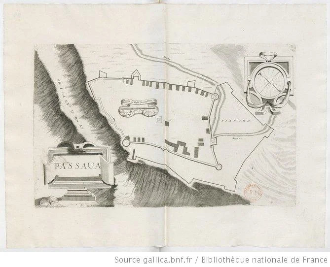
After Roman times, Las disappears from the record until the medieval period. The Frankish conquest of the Peloponnese in the early 13th century brought new lords to Laconia. Mani, as part of the Principality of Achaea, was granted to the French nobleman John of Nully. Sometime after 1218, Nully built a castle on the hill of Las. The French called it Passavant — possibly from the motto *Passe-Avant*, 'move forward,' or from similar place names in northeastern France. In Greek it became Passavas.
Nully's Barony of Passavant comprised four knights' fiefs. Its history is largely unrecorded. The castle fell to the Byzantines around 1263, passed through Byzantine hands during the Despotate of the Morea, was briefly held by the Ottomans, sacked by a Spanish fleet under Alonso de Contreras in 1601, regarrisoned by the Ottoman general Kuesy Ali Pasha in 1669, and captured by Venetians and Maniots together in 1684. The Venetians carried off the cannons and demolished the fortifications so the site could not be used again.
Then came the episode that local memory preserved longest. When the leader of the Maniots was executed by the Ottomans, his mother organized the men of nearby Skoutari to enter the castle disguised as priests on Easter Sunday. Once inside they drew hidden weapons. Of the 700 families in the castle, few escaped. After that the castle was abandoned and has not been inhabited since.
What Leake Found
The British antiquarian William Martin Leake visited Passavas in the 19th century and found, at the southern end of the eastern wall, a section of ancient Greek masonry — about 50 paces long, two-thirds the height of the medieval wall, formed of polygonal blocks, some four feet long and three broad. This was the Hellenic wall of Las visible within the medieval fortifications of Passavas. It confirmed the continuity of the site across more than two millennia.
The castle itself, built after the 13th century, is roughly quadrilateral — about 180 meters long and 90 meters wide. Of the large round towers that once anchored its corners, only the northwestern one survives. A square tower marked the northeastern corner, the castle's highest point. The wall was not especially tall; the chemin de ronde stood barely 2 meters above the castle's interior, and the northeastern face was protected more by the steep rocky hillside than by masonry. During the Ottoman occupation, a mosque occupied the center. Today only the ruins remain, on a hill above the Laconian Gulf, overlooking the same sea that Pseudo-Scylax sailed when he wrote the name down.
From the Air
Las (Passavas hill) sits at approximately 36.73°N, 22.50°E on the eastern coast of the Mani Peninsula, in Laconia, southern Peloponnese. The nearest airport is Kalamata International (LGKL), approximately 60 km to the northwest. Approaching from LGKL on a southeast heading, the Taygetos mountain range fills the western horizon before the Mani Peninsula narrows toward Cape Matapan. The Laconian Gulf opens to the east. Passavas hill is identifiable at lower altitudes (2,000–4,000 feet) as a rocky promontory with ruined walls, set back slightly from the shoreline near the village of Skoutari. The coast here is thinly populated and largely undeveloped; visibility is typically excellent in clear Mediterranean weather.
Nearby Stories
- Barony of Geraki 8 km away
- Battle of Kalamata (1685) 14 km away
- Siege of Coron (1533–1534) 23 km away
- The Dokos Shipwreck 50 km away
- Hydra: Fire Ships and Stone Mansions 80 km away
- Battle of Cape Spada 90 km away
- Siege of Chania (1645) 155 km away
- Temple of Zeus, Cyrene 397 km away