
Limehouse Cut
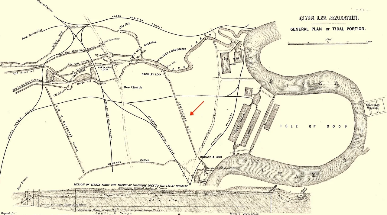
On 10 May 1768, a mob of five hundred men descended on a wind-powered sawmill at the southern end of a half-built canal in Limehouse and tore the machinery to pieces. Their grievance was simple: Charles Dingley's mill was the first of its kind in England, and the hand-sawyers who watched it could see their livelihoods sliding off its blades. Parliament responded the next year by making the destruction of mills a felony. Dingley rebuilt. The canal he had helped promote opened in 1770, ruler-straight from Bromley to the Thames at Limehouse, two and a half miles of new water cut through marshy fields. It was London's first wide-gauge canal, the oldest of them all, and within a century it would become the foulest open sewer in the East End and the witness to nearly everything that made Victorian London notorious.
Stinkhouse Bridge
The bridge over the Cut at Bow Common Lane was called Stinkhouse Bridge in official documents — not a nickname, the actual name on the magistrates' reports of 1826. Chemical manufacturers had set up along the Cut because the land was desolate and the regulators were elsewhere. Their effluent emptied into the canal. The Black Ditch, a medieval sewer running down from Spitalfields, fed in beneath the water by syphon and overflowed in storms. Joseph Bazalgette himself was called out more than once. "The smell is so bad that sometimes we cannot sleep in our beds," complained an 1856 petition. In 1866 the chemical works around the bridge caught fire — a blaze so vast, locals said, that every unit of the London Fire Brigade knew where to go just from the glow in the sky. People jumped into the Cut to escape the flames. The water was so dirty that when a labourer dived in to save a drowning woman, the magistrate gave him special compensation from the poor box.
Cholera and the Map That Broke a Theory
By 1849, William Farr was reporting that people who lived along the Lea had no clean drinking water and were dipping their pails into the Cut itself. The canal, he wrote, was "a receptacle for dead dogs, cats, and other small animals." Cholera deaths followed. When a major epidemic struck East London in 1866, the conventional wisdom — the miasma theory — blamed the stink rising from the water. The Lancet was not convinced. Its sanitary commissioners plotted every case on a large map and discovered something the doctrines could not explain: living near the Cut had nothing to do with dying of the disease. The map pointed instead at the East London Waterworks Company's mains, which had been contaminated with faecal matter and pumped into homes across the district. The Cut, vile as it was, had been falsely accused. The investigation became one of the first decisive blows against miasma and a step toward the modern germ theory of disease.
Lifeboats and the Fenian Barracks
Despite the stench, the Cut was a working canal, and remarkable things were built on its banks. The boatyard of T & W Forrestt, at a spot called Norway Yard, built self-righting lifeboats for the Royal National Lifeboat Institution and tested them in the canal water itself. According to the firm's own records, those boats saved upwards of twelve thousand lives. When General Gordon needed urgent relief in Sudan, Forrestt's delivered a hundred specially designed Nile boats in under a month. Across the Cut from the lifeboat yard sat the worst slum in London — the Fenian Barracks, a tight grid of streets centred on Furze Street where Charles Booth's researchers were told that "only Irish were tolerated to settle." Police entered in groups and were sometimes carried out in ambulances. Inspector Carter told Booth's man George Duckworth that arrests were impossible without a rescue mob assembling. Adjoining houses had internal passages cut between them so residents could vanish if the constables came calling.
Sunday Speakers and a Quiet Towpath
Dod Street, a canal-side row of factories on the north bank, became famous for something other than industry. In the 1880s socialists gathered there on Sundays to speak — John Burns, Eleanor Marx, William Morris, George Bernard Shaw. The police treated the meetings as subversive and tried to break them up by arresting orators for obstructing a highway that, being lined with closed Sunday factories, had no traffic to obstruct. The crackdown only swelled the crowds, a tactic Shaw later named "the Dod Street trick." A few hundred metres downstream stood Henry Herrmann's innovative furniture factory — the first in England to mass-produce hardwood furniture by machine, electrically lit by Herrmann's own generator because no public supply yet reached Limehouse. The factory burned spectacularly in 1887; the Fire Brigade's floating engines saved the neighbouring saltpetre works.
What the Cut Carries Now
Today the chimneys are gone and the sediment has settled. The Cut is part of the Lee Navigation, administered by the Canal & River Trust, and most of the traffic is narrowboats and weekend cyclists tracing the four-sided loop formed by the Cut, the Lee, the Hertford Union Canal, and the Regent's Canal. In July 2003 an award-winning solution opened the last stubborn stretch where the Blackwall Tunnel approach had blocked the towpath — sixty floating pontoons forming a 240-metre walkway, its edges glowing green at night. On 25 January 1981, four Labour politicians stood on the bridge over the former Limehouse Lock and issued the Limehouse Declaration that founded the SDP. At the end of the London 2012 torch relay, David Beckham arrived by speedboat through this same canal to the Olympic opening ceremony. The Cut has been many things in two and a half centuries. It is, for the moment, a quiet one.
From the Air
Limehouse Cut runs roughly east-northeast from Bow Locks (51.5294°N, -0.0094°W) to Limehouse Basin (51.5119°N, -0.0341°W), visible from altitude as a near-straight strip of water cutting diagonally through the East End. London City Airport (EGLC) sits just east, with Heathrow (EGLL) west and Stansted (EGSS) to the north. Best viewed from low altitude on clear days; the canal's geometric straightness distinguishes it from the meandering Lea and Thames nearby.
Nearby Stories
- Stevenage 5.7 km away
- Malling Abbey 5.7 km away
- 1952 Farnborough Airshow Crash 7.7 km away
- Ingatestone Hall 8.2 km away
- Hellfire Caves 9.1 km away
- The Carrington Event: The Solar Storm That Could Happen Again 9.8 km away
- Bletchley Park 16 km away
- Castle Hedingham 23 km away