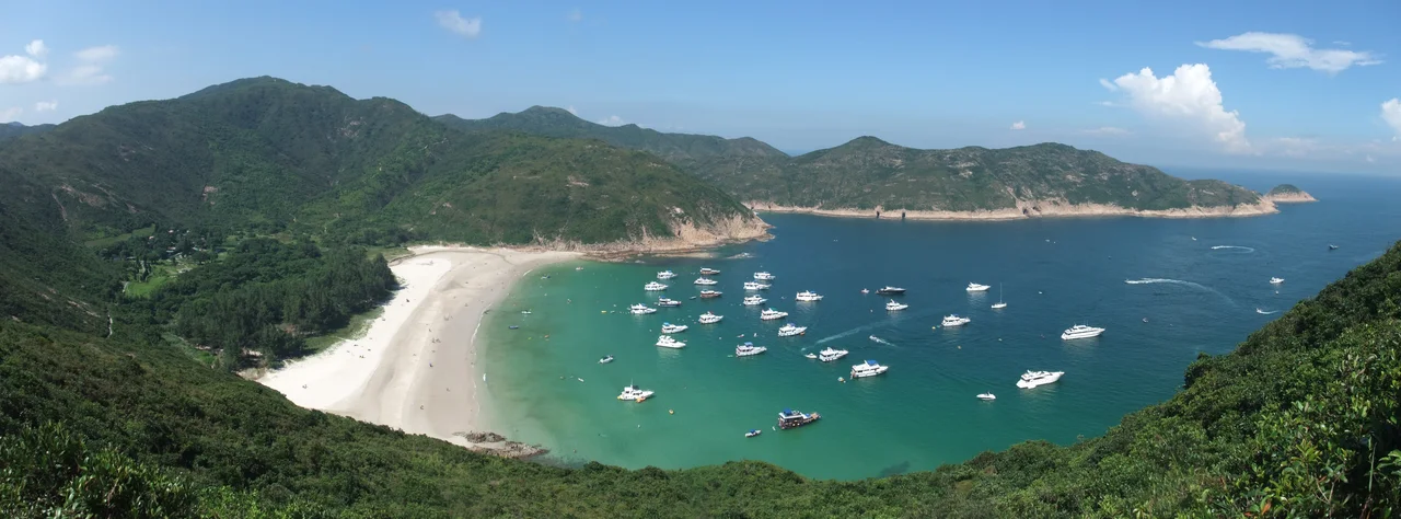

Long Ke Wan
CNN Travel once named it one of the world's best beaches, and yet most people who have lived in Hong Kong their whole lives have never seen it. Long Ke Wan sits in the southeastern corner of the Sai Kung Peninsula, tucked inside Sai Kung East Country Park, accessible only on foot — the end of stage one of the MacLehose Trail, the beginning of stage two. There is no car park here, no concession stand, no lifeguard. Just a long curve of pale sand, water that turns from turquoise to deep blue as it deepens, and the green hills of the Sai Kung Geopark closing it in on three sides.
Where the MacLehose Trail Rests
The MacLehose Trail runs 100 kilometres across Hong Kong from Sai Kung in the east to Tuen Mun in the west, and its first two stages use Long Ke Wan as a junction point. Hikers completing stage one arrive here from the High Island Reservoir direction, descending from the ridge into the bay. Those beginning stage two set off from the same point toward Pak Tam Au.
The bay sits directly north of the East Dam of High Island Reservoir, one of Hong Kong's engineering landmarks — a curved concrete dam built in the early 1970s that enclosed a sea inlet to create freshwater storage. The geopark columns visible along the reservoir's coastline, hexagonal volcanic rock formations created by ancient lava flows that cooled slowly and cracked into geometric patterns, continue around the headlands near Long Ke Wan. The hike to reach the bay passes through this landscape, which earned UNESCO Global Geopark status in 2009.
The Chapel Built in 1918
On the northwestern shore of the bay, in the small settlement of Long Ke, a Catholic chapel stands that has been here since 1918. The Nativity of Our Lady Chapel is one of the historic churches of the Sai Kung Peninsula, a scattered group of mission churches built in remote coastal villages in the late nineteenth and early twentieth centuries by PIME — the Pontifical Institute for Foreign Missions, a Milan-based missionary society.
The Sai Kung Peninsula had a significant Catholic presence from the mid-nineteenth century, when French missionaries established communities among the fishing and farming families of the coast. The chapel at Long Ke was built to serve the local Catholic community of the village, and it still stands, a whitewashed building looking out over the bay it has overlooked for more than a century. Long Ke itself is a recognised village under the New Territories Small House Policy, meaning that members of its indigenous community retain residency rights here despite the remoteness.
A Beach That Earns Its Solitude
The sand at Long Ke Wan is pale and fine, sheltered enough by the bay's orientation to be swimmable in reasonable conditions. The water is clear — the Sai Kung Peninsula's eastern coast is among the least industrialised and least polluted in Hong Kong, far from the harbour crossings and container terminals of the west.
Reaching the beach requires commitment. Hikers typically approach via the MacLehose Trail — a journey of several hours from the nearest road access points — or by kai-to ferry from Wong Shek Pier, which operates on limited schedules. Neither option is casual. The effect of that barrier is a beach that remains uncrowded even on weekends when every other accessible beach in Hong Kong is packed. The effort filters the visitors. Those who arrive tend to stay longer, move more slowly, and pay more attention to where they are. Long Ke Wan rewards that attention.
Sai Kung's Far Edge
Long Ke Wan sits within Sai Kung East Country Park, the largest country park in Hong Kong, covering the rugged eastern portion of the Sai Kung Peninsula. The park protects a landscape that would otherwise face pressure from the territory's relentless development demand: granite peaks, volcanic sea cliffs, forested valleys, and a coastline that alternates between exposed headlands and sheltered bays.
The bay is roughly equidistant between the town of Sai Kung — the gateway to the peninsula, known for its seafood restaurants and weekend market — and the open waters of the South China Sea to the east. In storm conditions, the hills funnel and amplify the wind, and the sea inside the bay can become rough quickly. In calm weather, particularly in the early morning before the day's heat builds, Long Ke Wan is as peaceful as anywhere in Hong Kong gets. The chapel bell, when it rings, carries across water that has no cars driving past, no ferry horns, no city noise to absorb it.
From the Air
Long Ke Wan is at approximately 22.369°N, 114.382°E, on the southeastern coast of the Sai Kung Peninsula. From the air at 2,000–4,000 feet, the bay is visible as a distinct curved arc of pale sand set into green hills, immediately north of the East Dam of High Island Reservoir, whose curved concrete structure is a useful navigational landmark. Sharp Peak (468 m) rises to the northwest. The Sai Kung East Country Park fills the surrounding ridges. Mirs Bay and the open South China Sea are visible to the east and southeast; on clear days, the outer islands of the Ninepin Group (Po Pin Chau) are visible to the south. Hong Kong International Airport (VHHH) is approximately 48 km to the west. This portion of the Sai Kung coastline is one of the most visually dramatic sections of Hong Kong territory when seen from low altitude.
Nearby Stories
- Sha Chau and Lung Kwu Chau Marine Park 5.9 km away
- Wanshan Archipelago 22 km away
- Hong Kong 12 25 km away
- Second Battle of Chuenpi 27 km away
- Mount Guanyin (Dongguan) 43 km away
- Battle of Penghu 474 km away
- Penghu Air Raids 482 km away
- Checheng Fu'an Temple 592 km away