Lorentz River
Three names, one river. The Asmat people who live in its lower reaches call it Unir, or Undir. The Dutch surveyors who mapped it called it Noordrivier, the Northern River. And in 1910, after Hendrik Albertus Lorentz returned from the highlands with the news that Europe had refused to believe for nearly three centuries, that there were glaciers in New Guinea, the river was renamed for him. It begins somewhere high in the central east-west mountain range of the island and falls south through rainforest into Flamingo Bay on the Arafura Sea. About 3,500 kilometers from Jakarta, the capital it rarely thinks about.
The Three Expeditions
At the start of the twentieth century, Dutch New Guinea was among the least-mapped places on Earth. The river that would later bear Lorentz's name was the way in. Three expeditions, between 1907 and 1913, used its navigable lower stretch as a highway toward the snowcapped peaks still called, on period maps, the Wilhelmina summit, the top of the mountain now known as Puncak Trikora. The first expedition failed to reach the mountain at all. The second reached the snow line but could not climb it. The third, finally, stood on the summit on 21 February 1913. Each expedition traveled with long teams of porters, many of them Dayak Kenyah men recruited from the Apo Kayan in Borneo, who knew river work better than the Europeans and who carried much of what made those journeys possible.
The Man Who Saw the Ice
Hendrik Albertus Lorentz, the river's colonial namesake, led the expedition that reached the snowfield of Puncak Trikora in 1909, with six Kenyah porters at his side. It was his report, submitted after that trip, that formed the scientific basis for Lorentz National Park, established as a predecessor reserve in 1919 and expanded in later decades into what is now one of the largest protected areas in the Asia-Pacific region. The park carries his name; so does the river that carried him inland. The porters who walked with him carry no plaques. Their names are not generally preserved in the cartography that followed.
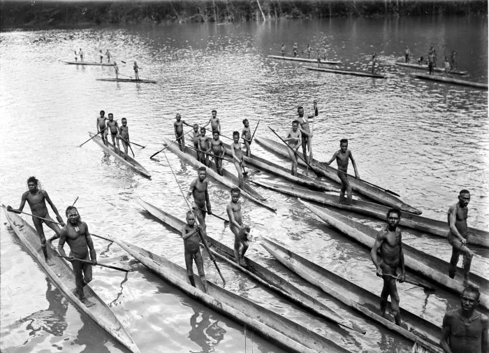
From Ice to Sea
The Lorentz flows through some of the most biologically rich terrain on Earth. In the upper watershed it drains alpine meadows and glacial remnants near Puncak Trikora. Midway, it cuts through dense tropical rainforest in a zone of annual rainfall between 4,238 and 5,547 millimeters, the kind of water budget that maintains the canopy year-round. The warmest month averages 23 degrees Celsius, the coldest 20, with remarkably little seasonal variation in temperature and a wettest month of May averaging 594 millimeters of rain. Near the coast, the river fans into mangrove channels and tidal flats where the Asmat people have navigated for generations by dugout canoe. Flamingo Bay, its mouth on the Arafura Sea, was named by Europeans who saw the birds that visit there.
A River With Three Languages
When Western New Guinea became part of Indonesia, the official name shifted to Unir, honoring the Asmat language that had never stopped using it. Lorentz remains the international reference. Noordrivier survives in Dutch archival materials, obsolete now for most practical purposes. A river with three names in three languages speaks to something about this part of Papua, a place still negotiating what to inherit from which set of mapmakers. The water itself does not notice. It continues south from the mountains, carrying silt, nutrients, and sometimes logs from storms higher up, flattening into the delta where the rainforest ends and the Arafura begins.
What the River Enables
The Lorentz, together with its basin, supports ecosystems that UNESCO and the Indonesian government have designated among the most significant on Earth. Lorentz National Park, 25,000 square kilometers of watershed, protects snow peaks, alpine tundra, cloud forest, lowland rainforest, mangroves, and coastal waters in one continuous reserve. The river threads these zones. It also threads the lives of the Asmat and other peoples of the southern lowlands, who rely on it for transportation, fishing, and cultural reference. Flying over the river's course, from the Sudirman peaks to the Arafura coast, you see almost no roads. You see green, water, more green. That is the river's country. It is the character of the whole basin.
From the Air
Located at approximately 5.54°S, 138.04°E, flowing through South Papua. The river originates in the central New Guinea highlands near Puncak Trikora and reaches the Arafura Sea at Flamingo Bay. Nearest airport for the lower river is Ewer (ICAO: WAKE) near Agats; the upper reaches approach Timika (ICAO: WABP). Expect heavy tropical rainfall year-round and unpredictable convective weather. Morning flights offer best visibility; by afternoon clouds typically obscure the upper watershed.
Nearby Stories
- Western New Guinea 30 km away
- Baliem River 41 km away
- Puncak Trikora 104 km away
- Tembagapura 132 km away
- New Guinea Mangroves 145 km away
- Puncak Jaya 165 km away
- Boven-Digoel Concentration Camp 200 km away
- Marchinbar Island 613 km away