.jpg)
Puncak Trikora
The Dani who farmed the sweet-potato terraces around Lake Habbema called the mountain Ettiakup. They had watched its glaciers shine in the thin highland sun for as long as anyone could remember. In 1909, a Dutch expedition led by the diplomat Hendrikus Albertus Lorentz climbed high enough to see the peak up close and renamed it Wilhelmina, after their queen. In 1963, Indonesia took control of western New Guinea and renamed it again - Puncak Trikora, after the speech Sukarno had given two years earlier demanding exactly that takeover. Sometime between those two renamings, the ice itself disappeared.
Three Names, One Mountain
Puncak Trikora rises to 4,730 meters - or 4,750, depending on the survey - in the eastern Sudirman Range of the Maoke Mountains. It sits behind Puncak Jaya (4,884 m), making it either the second or third highest summit on the island of New Guinea, depending on whether more recent SRTM radar data crediting Puncak Mandala with 4,760 meters is accepted. The name *Trikora* is an acronym. It stands for *Tri Komando Rakyat*, or "People's Triple Command," the three demands Sukarno issued in a December 1961 speech in Yogyakarta: defeat the formation of an independent West Papua, raise the Indonesian flag there, and be ready for general mobilization. When Indonesia formally took control of the territory in 1963, it renamed the mountain to make its political meaning inescapable. The Dani name Ettiakup still circulates among communities around Lake Habbema.
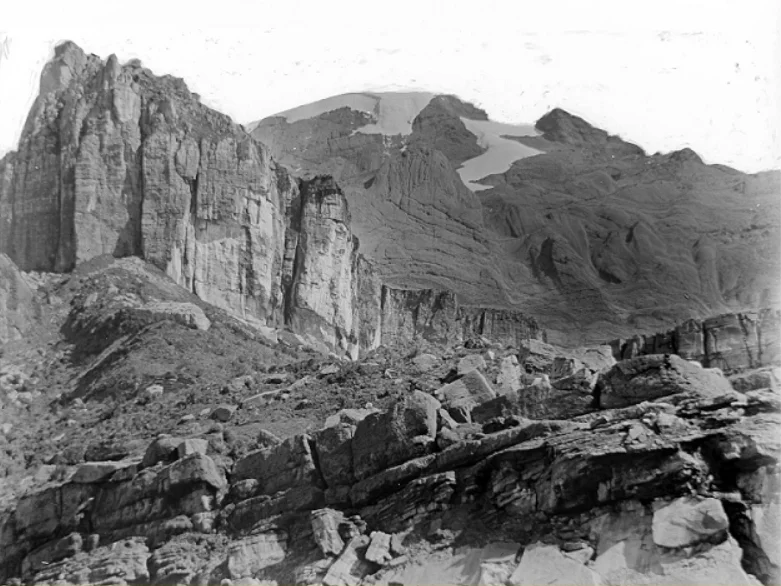
The Ice That Was
At the start of the 20th century, all of New Guinea's highest peaks carried ice. Puncak Jaya, Puncak Mandala, Ngga Pilimsit, and Puncak Trikora all sat beneath equatorial glaciers - one of the strangest geographical phenomena on Earth. When the Second South New Guinea Expedition first reached eternal snow in 1909, the ice cap on Trikora still descended to 4,400 meters. Between 1936 and 1962, the ice cap on Trikora melted completely. The mountain's white crown - the thing that had drawn Dutch explorers up the Noord River and into a country where four of them died before the snow was reached - was simply gone by the time Sukarno's Trikora speech renamed it. Only Puncak Jaya still holds a fragment of the old equatorial ice, and that too is shrinking year by year.
The Geology Under the Ice
The mountain itself is older than the glaciers that briefly crowned it, and older still than any name it has carried. The central range of New Guinea was lifted in the late Miocene by an oblique collision between the Australian and Pacific tectonic plates - a slow, grinding encounter that geologists call the Melanesian orogeny. The rock of Puncak Trikora is middle Miocene limestone, now tilted and fractured, uplifted thousands of meters from what was once a shallow sea. Apatite fission-track thermochronology has clocked a dramatic asymmetric unroofing of the Irian fold belt across the Pliocene and Pleistocene, meaning the mountains have been rising fast enough and eroding fast enough that the landscape you see today is geologically young - cliffs still sharp, valleys still cutting down.
What the Dutch Lost on the Way Up
The Noord River, navigable deep into the lowlands, made Trikora more approachable than the other snow peaks of Dutch New Guinea. In July 1907, the first Dutch expedition established Camp Alkmaar where the river stopped being navigable; they failed to penetrate the high range. The second expedition, in 1909, reached the equatorial snow itself on 8 November at 4,460 meters - Lorentz and eight companions, including the navigator Jan Willem van Nouhuys. They did not attempt the summit. From a ridge they spotted a lake to the north and named it Habbema, for a member of their party. The return trip cost four expedition members their lives. The summit itself was not reached until 21 February 1913, by a team of three from the Third South New Guinea Expedition - Alphons Franssen Herderschee, Paul Hubrecht, and Gerard Versteeg - supported by a baggage train of 241 soldiers, porters, and Dayak boatmen. Eight years later, on a 1921 expedition, Hubrecht climbed Trikora again and noted how much the ice had already retreated since his first ascent.
Climbers' Mountain, Claimants' Flag
Today Trikora draws a small number of expedition mountaineers each year, usually as part of "Seven Second Summits" attempts for those chasing the second-highest peaks on each continent. Access runs from Wamena up through the Baliem Valley, past Lake Habbema, along the same basic route the 1921 Kremer expedition used. The technical climbing is not severe compared to Puncak Jaya, but the logistics are brutal - weather, permits, political sensitivities. The mountain stands inside Lorentz National Park, a UNESCO World Heritage Site, but it also sits inside the wider West Papuan independence conflict. Its official name is still Trikora, still a slogan for the integration Sukarno demanded. The Dani name Ettiakup remains what the people who live closest to the mountain call it.
From the Air
Centered near 4.35S, 138.65E, Puncak Trikora rises 4,730m in the Sudirman Range of the Maoke Mountains. It is the second-or-third highest peak in New Guinea and Australasia. The peak is snow-free but glaciated neighbors once ringed it; today only Puncak Jaya (to the southwest) retains ice. Nearest approach airports: Wamena (WAVV/WMX) to the north in the Baliem Valley, Timika (WABP/TIM) to the south. VFR overflight requires altitudes above FL160 for safe terrain clearance over the range. Morning flights offer the clearest views - afternoon orographic cloud builds quickly over the summit ridgeline.
Nearby Stories
- 1981 Irian Jaya Earthquake 1.6 km away
- Baliem Valley 23 km away
- Lorentz National Park 42 km away
- 2016 Alfa Indonesia DHC-4 Crash 62 km away
- Western New Guinea 90 km away
- New Guinea Highlands 116 km away
- Lake Sentani 215 km away
- Mamberamo River 288 km away