Lake Sentani
The Sentani people have a saying about their lake: it is the home of the rainbows. At this latitude, so near the equator, rainbows in the sky are only possible after heavy rain hits at the right angle. But in Lake Sentani they are permanent. They swim. The Sentani rainbowfish - Chilatherina sentaniensis - is endemic to this one 104-square-kilometer body of water at the foot of the Cyclops Mountains, and when a school of them passes through clear water at the right depth, the old metaphor turns literal. The lake also holds the Sentani gudgeon and the Sentani goby, two more fish species found nowhere else on Earth. It holds a World War II naval base site, megalithic rock carvings of disputed origin, and Indonesia's most densely populated region in New Guinea packed along its shores. The water is shallow and warm. The depths may still remember the sea.
Shaped by a Fault
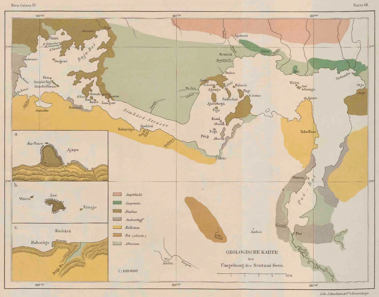
Lake Sentani lies at the base of the Cyclops Mountains, a range of Mesozoic mafic and ultramafic rocks that push up sharply from the coastal plain of northeast Papua. The lake sits in a fault-controlled depression 73 meters above sea level, irregularly shaped - roughly 28 kilometers long east to west, 19 kilometers across at its widest north-to-south. The best-supported theory of its origin holds that it evolved by tectonic damming and uplift of an arm of the sea. The theory fits the geology but remains unproven in one specific way: the connection to the ocean has not been directly demonstrated. Preliminary sediment samples from the eastern lakebed have yielded sparse populations of Centropyxid microfauna, which are usually associated with brackish or polluted water. This leaves open the possibility that residual salinity lingers in the deeper parts of the lake, a trace of an ocean arm the land long ago sealed off.
A Bathwater Ecosystem
Lake Sentani runs thermally stable - 29 degrees Celsius and almost unchanging through the top ten meters of water. Surface pH stays between 6.2 and 6.8. Plankton levels are low, 1 to 2 milligrams per liter, which keeps the water clear in most basins. The westernmost basin is the exception: water circulation is limited there, turbidity doubles, and seasonal algal blooms kill fish each year. The lake holds 34 fish species in total - 13 native residents, 8 anadromous species that move between lake and sea, and 13 introduced species. Carp and tilapia, stocked accidentally and intentionally for aquaculture, now coexist with the endemics. Sawfish up to three meters long - the largetooth sawfish - were common in the lake until the 1970s and feature heavily in traditional Sentani art. They appear to be locally extinct now, surviving only on carved poles and painted bark cloth.
A Naval Base at 73 Meters Elevation
During World War II, the United States Navy built a naval base on the lake as part of Naval Base Hollandia after the April 1944 invasion. The base operated from 1944 to 1945 - an unusual siting decision, an inland lake 73 meters above sea level pressed into service as part of the support network for the Pacific campaign. The nearby Hollandia airfield complex, on the Sentani plain just north of the lake, became one of the biggest Allied air hubs in the southwest Pacific. Hollandia is now Jayapura. The lakeside and airfield infrastructure formed the template on which Indonesian Jayapura Regency would later grow, and the drainage and road networks the Navy built still underlie the modern layout.
Stilts Over Water
The Sentani people live on the islands in the lake, around its perimeter, and in villages on the near shore. Many dwellings are built on posts above the water itself - a traditional arrangement that keeps homes cool, catches breezes, and places fishing platforms at the front door. It also deposits household sewage into the lake, producing locally high coliform bacteria counts and nutrient enrichment feeding the algal blooms. Sago harvesting and fishing remain the subsistence core, sustained for centuries though under pressure now from population growth, introduced species, and water hyacinth that has spread since the 1970s. A proposed hydroelectric dam on the outflowing Jafuri River has generated feasibility and environmental-impact studies, but the cost-benefit analysis has not been publicly released. A reforestation project on the slopes around the lake, backed by forestry companies working in Papua, has been initiated recently to counter grassland erosion.
Doyo Lama and the Stone Carvings
On a hill at the northwest corner of Lake Sentani, a site called Doyo Lama carries megalithic remains and rock carvings that nobody has been able to satisfactorily explain. Some archaeologists have proposed Micronesian influence - the stone-working styles would fit - but the cultural lineage of the carvings remains contested. Much of the mountainous terrain between the lake's north shore and the Pacific Ocean falls within the Cyclops Strict Nature Reserve, and the future management of reserve and buffer zone and the ecological health of the lake are closely tied together. Water flows out of Lake Sentani into the Jafuri and Tami Rivers to the Pacific Ocean near the Papua New Guinea border. The lake receives its water primarily from direct precipitation - about two meters annually around the shore - with mountain streams filling the rest. What comes out of the lake may yet be turned into electricity. What lives in the lake, for now, is still its own thing.
From the Air
Lake Sentani is centered at 2.61 degrees south, 140.52 degrees east, in the Jayapura Regency of Indonesian Papua, about 20 kilometers southwest of Jayapura City. The lake is an irregular body roughly 28 km east-west by 19 km north-south, clearly visible from cruising altitude as a large freshwater body at the foot of the Cyclops Mountains, which rise sharply to the north between the lake and the Pacific coast. Sentani Airport (ICAO WAJJ), Papua's main airfield, is immediately north of the lake's northern shore - a prominent reference for navigation. The lake outflows east to the Jafuri and Tami Rivers. Equatorial weather with frequent afternoon convective activity; mountain wave effects possible on north side.
Nearby Stories
- Foja Mountains 93 km away
- Battle of Wakde 108 km away
- Battle of Driniumor River 157 km away
- Aitape 166 km away
- Highland Papua 168 km away
- Baliem Valley Campaign 207 km away
- Battle of Lone Tree Hill 217 km away
- HMS Nabaron 658 km away