.jpg)
New Guinea Highlands
For most of the 19th century, European maps of New Guinea showed the interior as a blank. The coast had been charted, but the ranges beyond were something else entirely - a wall of cloud forest above 3,000 meters, cut by gorges, unreached by river navigation. What the maps missed was that the blank space was not empty. When the first highland valleys were finally flown over in the 1930s, Australian pilots looked down at wide green bowls filled with villages, terraced gardens, and hundreds of thousands of people. A continuous human civilization had lived there for thousands of years, entirely unknown to the outside world.
A Spine Across an Island
The New Guinea Highlands - called the Central Range or Central Cordillera - run roughly east-west for more than 1,600 kilometers along the length of the island, from the Weyland Mountains above Wondama Bay in the west to Milne Bay Province in the east. The range crosses the political border midway, with the Indonesian half containing the higher peaks, including Puncak Jaya at 4,884 meters, the tallest mountain in Oceania. From east to west, the range chains through the Owen Stanleys, the Bismarcks, the Star Mountains, and the Maoke or Snow Range. Mount Wilhelm, at 4,509 meters, is an extinct volcano with a crater lake on the Papua New Guinea side. H.A. Lorentz's 1909 expedition into the Maoke found perpetual snow at 4,461 meters - ice that has since retreated dramatically up the slopes.
Sweet Potato Revolution
The highlands had been farmed for at least 10,000 years - some of the earliest evidence of agriculture anywhere in the world has been found in the swamps of the Wahgi and Baliem valleys - but the arrival of the sweet potato, probably within the last 400 years via trade routes from South America, changed everything. Before the sweet potato, highland agriculture supported smaller, more dispersed populations with distinct forms of labor division. Sweet potato thrived at altitudes where yams and taro struggled. Populations in the highland valleys grew rapidly, and with them a culture of intensive gardening, pig-raising, ceremonial exchange, and inter-tribal warfare that persists in modified form today. When Australian patrol officers first walked into the Wahgi Valley in 1933, they found a society whose scale they could not have predicted from the coast.
The Kokoda Track
The Owen Stanley Range in the southeast of Papua New Guinea became, in 1942, one of the most brutal theaters of the Pacific War. Japanese forces pushed inland from the north coast along a foot track over the range, aiming to take Port Moresby and, from there, threaten northern Queensland on the Australian mainland. Australian militia and regular troops, supported by Papuan carriers who were often pressed into service in grim conditions, fought them to a standstill in the mud of the Kokoda Track. The Japanese advance was stopped 50 kilometers from Port Moresby; the campaign cost thousands of lives on both sides, and many Papuans who carried the wounded and supplies were never formally recognized. Today Kokoda is a pilgrimage trek for Australians retracing their grandfathers' retreat and counterattack.
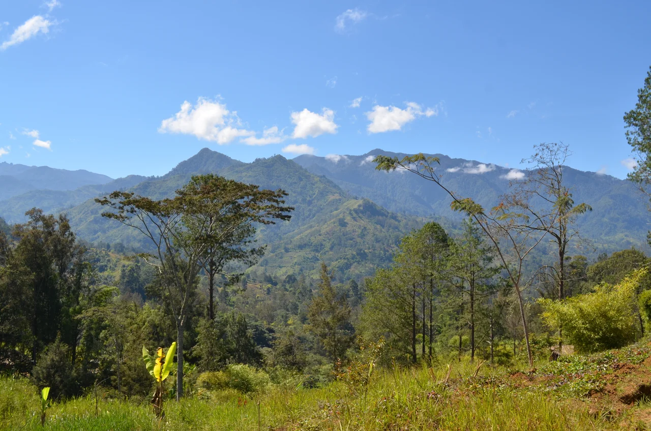
Where Birds of Paradise Sing
Ecologically, the Highlands are a vertical layer cake of habitats. Lower montane forest from 1,000 to 1,500 meters gives way to upper montane forest dominated by moss-draped Nothofagus beeches, then to high mountain forest of Podocarpus, Dacrycarpus, and Araucaria conifers, and finally to alpine grasslands above 3,000 meters. Of the 90 mammals on the island, 44 are endemic; of 348 birds in the range, 55 are endemic. Mount Giluwe is a major birdwatching site for birds of paradise - the ribbon-tailed astrapia, the long-bearded honeyeater. The critically endangered Bulmer's fruit bat survives in tiny populations on the PNG side. On the highest grasslands, just nine mammal species persist; four of them, including the glacier rat and alpine woolly rat, live nowhere else on Earth.
Islands of Language, Islands of Protection
The Highlands are the most linguistically diverse country on the planet. The island as a whole has around 1,073 languages; a substantial share of them - including Dani, Enga, Huli, Melpa, Kuman - are spoken only in specific highland valleys, divided from their neighbors by ridges as effectively as any sea. Each valley's inhabitants had until recently their own ceremonial economies, warfare patterns, and material cultures. A patchwork of protected areas tries to keep parts of this landscape intact: Lorentz National Park in the Indonesian west, Mount Wilhelm National Park and Jimi Valley National Park in PNG, the Weyland Mountains Nature Reserve, and several community-managed wildlife areas. Gold, copper, and nickel mining reach further into these valleys each decade. The Highlands Highway, which threads east-west along the PNG side, has brought both economic connection and new pressures. How the highlands change in the next generation will depend largely on decisions made by the communities who have always shaped them.
From the Air
Centered near 5S, 140E, the Central Range runs 1,600km from Wondama Bay to Milne Bay with peaks to 4,884m (Puncak Jaya). Key gateway airports: Timika (WABP/TIM) and Wamena (WAVV/WMX) in Indonesian Papua; Mount Hagen (AYMH/HGU), Goroka (AYGA/GKA), and Port Moresby (AYPY/POM) in PNG. Direct VFR crossing of the range requires FL200+ clearance; most general aviation flights follow valley routes. Orographic cloud builds by mid-morning; sunrise provides the clearest highland views. Expect severe turbulence at ridge crossings in trade wind flow.
Nearby Stories
- 1981 Irian Jaya Earthquake 42 km away
- Battle of Bobdubi 49 km away
- Merpati Nusantara Airlines Flight 9760D 58 km away
- Ok Tedi Environmental Disaster 61 km away
- Baliem River 79 km away
- Boven-Digoel Concentration Camp 94 km away
- Baliem Valley Campaign 116 km away
- Naval Base Hollandia 245 km away