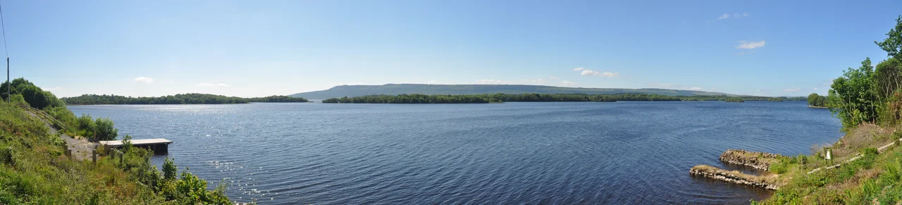

Lough Erne
In 1941, a Catalina flying boat lifted off Lower Lough Erne, banked west, and crossed neutral Irish territory in violation of every diplomatic convention. The aircraft was hunting the German battleship Bismarck. Ireland and Britain had quietly agreed that the lake's flying boats could shortcut across County Donegal to reach the Atlantic, saving the two-hour detour their neutrality would otherwise have required. The Catalina found the Bismarck. The Royal Navy sank it three days later. Today, the same lake is a fishing paradise and a tourist destination, but the story of how it got here threads back through ancient Celtic gods, medieval monastic scribes, secret wartime aviation, and the 2013 G8 summit when Obama and Putin walked its shoreline behind a four-mile fence.
The Drowning of a Goddess
Lough Erne takes its name from the Érainn, an ancient population group, or possibly from a goddess named Érann from whom the Érainn took their own name. The linguist T. F. O'Rahilly argued that Loch Éirne probably means lake of the goddess Érann. Patricia Monaghan, who wrote about Irish mythology, observed that the drowning of a goddess in a river is common in Irish mythology, typically representing the dissolving of divine power into water that then gives life to the land. Other tales explain the lake's existence differently. One says it formed when a magical spring-well overflowed. Another claims it burst from the ground during a battle between the Érainn and the army of High King Fíachu Labrainne, drowning the losers. A third folktale credits Partholón, who killed his wife's favourite hound, Saimer, in a fit of jealous rage; the lake was named after the dog. Loch Saimer remained an alternate name for centuries.
Two Lakes, One River, 150 Islands
Strictly speaking, Lough Erne is two connected lakes formed by widened sections of the River Erne. The smaller southern lake is the Upper Lough, higher up the river. The larger northern lake is the Lower Lough, or Broad Lough. The town of Enniskillen sits on the short stretch of river between them. The River Erne is 80 miles long and drains 1,680 square miles of countryside. The lakes contain more than 150 islands. The 1846 Parliamentary Gazetteer noted that the islands are popularly fabled to be as numerous as the days of the year, but a more sober count puts them at 90 in the Upper Lake and 109 in the Lower. Two drainage schemes, one in the 1880s and another in the 1950s, dropped the water level by about five feet, turning some former islands into peninsulas.
The Donegal Corridor
During the Second World War, RAF Castle Archdale on Lower Lough Erne was a key flying boat base for the Battle of the Atlantic. Aircraft based there hunted U-boats far out in the western approaches. The problem was geography. Northern Ireland's coast pointed east-southeast, which meant every Atlantic patrol began with a long detour south around the Republic of Ireland's neutral airspace. The two governments reached a secret arrangement. Royal Air Force aircraft from Lough Erne were permitted to fly west across County Donegal directly to the Atlantic, saving up to two hours per sortie. The path became known as the Donegal Corridor. It was one of the many ways neutral Ireland quietly helped the Allies. Without it, the Catalina that spotted the Bismarck on 26 May 1941 would have been hours late, and the largest German warship of the war might have reached safe French port.
Annalists on Belle Isle
In the late fifteenth century, on Belle Isle in Upper Lough Erne, scribes worked at compiling what would become the Annals of Ulster, one of the most important sources for medieval Irish history. The Erne islands had long attracted monastic communities. Devenish Island, in the Lower Lough, holds the ruins of a sixth-century monastery and a perfectly preserved round tower. Boa Island contains a pair of stone figures called the Boa Island figures, two-faced Janus-like statues whose age is debated but which probably predate Christianity in Ireland. White Island has a row of stone figures set into a church wall, again of uncertain date but probably early medieval. The islands functioned for centuries as a sanctuary network, places where learning continued through eras when the mainland was unsafe.
The G8 Behind Razor Wire
In November 2012, Prime Minister David Cameron announced that the Lough Erne Resort, a five-star hotel on the southern shore of the Lower Lough, would host the 39th G8 summit. It convened on 17 and 18 June 2013. The choice was deliberate. The British government wanted to demonstrate that Northern Ireland was peaceful enough for global leaders, even though dissident republican groups remained active. A four-mile metal fence ringed the resort. Razor wire topped the fence. Lower Lough Erne was closed to the public, and the airspace above it became a no-fly zone. Around 8,000 police officers were deployed, with 100 cells reserved at Maghaberry prison for any protesters who turned violent. A car bomb intended for the resort had already been defused 16 miles away in March. The summit proceeded without incident. It was also the last G8 summit attended by Russia, which was suspended the following year after the annexation of Crimea.
Anglers, Sailors, and the Garden Warbler
The Lough Erne Regatta is Ireland's oldest sailing event, with a lineage that traces back beyond 1820. The stretch of water alongside the Broadmeadow in Enniskillen has hosted stages of the World Waterski Championships every year since 2005. The Lough Erne Yacht Club operates from Gublusk Bay. The Royal National Lifeboat Institution maintains an inland lifeboat station at Gublusk and another at Carrybridge on the Upper Lough. Anglers come for pike, perch, brown trout, and the famous gillaroo. The islands are also the main Irish stronghold of the garden warbler, a small migratory songbird that is scarce throughout the rest of the country. The Erne Rivers Trust, an NGO, works to protect the lough's water quality for the benefit of all the species, human and otherwise, that depend on it.
From the Air
Located at 54.48 degrees north, 7.81 degrees west, in County Fermanagh, Northern Ireland. The lake system runs about 50 miles from southeast to northwest, with Enniskillen at its narrow middle. Recommended viewing altitude 3,000 to 6,000 feet above terrain for the full sweep of both lakes. From the air, the highly convoluted shoreline and constellation of more than 150 islands are unmistakable, with the larger Lower Lough running roughly north-south and Upper Lough Erne dotted with smaller islands. Nearest airports: St Angelo (EGAB) on the Lower Lough shoreline serves the area; Donegal (EIDL) is to the northwest, Belfast International (EGAA) to the east, City of Derry (EGAE) to the north. The Lough Erne Resort and the G8 summit site are on the southern shore of the Lower Lough. Atlantic weather brings frequent rain, low cloud, and gusty winds, especially in autumn and winter.
Nearby Stories
- Ulster Canal 1.3 km away
- Cliffoney 3.5 km away
- County Leitrim 6.4 km away
- Ballymote 7.7 km away
- Gortin 11 km away
- Fintona 11 km away
- Glencolmcille 19 km away
- Castlederg 21 km away