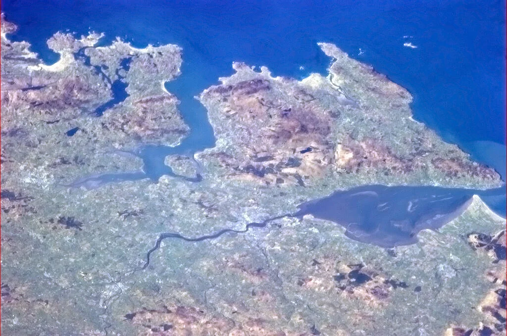

Lough Swilly
Its name means the lough abounding in eyes, or possibly in whirlpools, and in some tellings a many-eyed sea monster called Suileach once lived in its waters until Saint Colmcille killed him sometime in the sixth century. The monster has gone. The eyes remain. Lough Swilly is one of only three true glacial fjords in Ireland, a long blue tongue of Atlantic seawater that pushes forty kilometres inland between the Fanad and Inishowen peninsulas in County Donegal. From the air it looks like a wound a knife left in the north coast. From the deck of a ship it has, for at least two thousand years, looked like a way in.
The Lough That Watches
Glacial fjords are rare in Ireland; only Killary Harbour and Carlingford Lough share Lough Swilly's geological pedigree. Ptolemy of Alexandria put it on his map of the world in the second century AD, naming the hill fort of Grianán Ailigh that still crowns its southeastern shoulder. Shell middens dating to roughly 7000 BC line the lough's shores, evidence that Mesolithic communities were already prying limpets and oysters out of these waters when the climate first turned mild after the Ice Age. Stone Age tombs and Iron Age forts dot the surrounding hills. The lough has been a road, a larder, and a defence for longer than any nation here has had a name. Whooper swans winter on the reclaimed wetlands at its southern end in flocks of more than four thousand, alongside thousands of barnacle, brent, and greylag geese.
Departure Point of an Empire's End
On 14 September 1607, ninety followers of Hugh O'Neill and Rory O'Donnell boarded a French ship at Rathmullan on the lough's western shore. They were the last great Gaelic chieftains in Ireland, and they were leaving forever. The Flight of the Earls is one of those rare events where a single ship's departure marks the end of an era; the Plantation of Ulster followed, and four centuries of contested history began. Almost two hundred years later, in October 1798, the same lough watched another exit. A French fleet carrying Theobald Wolfe Tone of the United Irishmen, sent to support a rebellion that had already collapsed, was intercepted and defeated at the lough's mouth. Tone was captured and rowed ashore at Buncrana. He died in Dublin a few weeks later. The fjord that swallowed Gaelic Ireland's leaders also delivered the man who tried to invent Irish republicanism into the hands of his enemies.
Cannon, Concrete, and Cold Watch
Between 1800 and 1820, fearing another invasion attempt, the British built a ring of fortifications around the lough. Six Martello towers went up in 1804, each costing about 1,800 pounds and armed with smoothbore cannon firing round shot. Walking the shore today you can still see them: at Ned's Point near Buncrana, at Inch, at Knockalla and Macamish on the western side. Just before the First World War the War Office added Lenan Head Fort with 9-inch guns whose 12-mile range was, briefly, the longest in Ireland. During the war Lough Swilly became one of the great anchorages of the Royal Navy's Grand Fleet under Admiral Jellicoe; a steel boom slung between Macamish Point and Ned's Point, supported by armed trawlers, kept U-boats out. After Irish independence in 1922 the lough became a Treaty Port, garrisoned by British forces until 1938, when Fort Dunree was handed over. The fort is now a museum, where you can stand at the guns and look down a coastline that has been watched, in one uniform or another, for a thousand years.
The Wreck and the Gold
Lough Swilly is also a graveyard. On the night of 4 December 1811, a Royal Navy 36-gun frigate was caught in a gale at the entrance to the lough and driven onto the rocks. Of the estimated 253 people aboard, none survived. Roughly two hundred bodies washed up along the shore in the days that followed. More than a century later, in 1917, a German mine or torpedo sent the SS Laurentic to the bottom near Fanad Head with 3,211 gold ingots in her holds. The Royal Navy recovered 3,191 of them in a salvage operation that took years and remains one of the great underwater recoveries of the twentieth century. Twenty bars are still down there somewhere. Modern divers come to Swilly for the wrecks and for the dolphins, porpoise, and seabirds that thrive in the cold, clean water above them.
A Quieter Use
The Londonderry and Lough Swilly Railway, founded in 1853, eventually built a network of narrow-gauge lines that connected Derry to the lough's eastern shore and beyond into the Inishowen peninsula. Trains ran until 1953, when buses replaced them; the bus company itself finally closed in 2014, ending more than a century and a half of public transport bearing the lough's name. Today the towns along its shores - Buncrana on the east, Rathmullan on the west, Letterkenny at its southern end - live partly on day-trippers from Derry and partly on memory. The Fanad Head lighthouse, white against the dark cliffs at the lough's mouth, marks the way out into the open Atlantic. Stand on the pier at Rathmullan on a calm September evening and you can still see what the earls saw: a long quiet road of water, and at its end the open sea.
From the Air
Lough Swilly stretches from roughly 55.15 degrees north, 7.54 degrees west at its centre, running approximately south from Fanad Head and Dunaff Head deep into north Donegal. From cruise it is one of the most unmistakable features of Ireland's north coast: a long blue fjord between two peninsulas, with the Inishowen mass to its east and the Fanad peninsula to its west. The nearest controlled airport is City of Derry (EGAE) about 30 km east; Donegal Airport (EIDL) lies roughly 40 km west-southwest. Belfast International (EGAA) is the closest major hub at around 115 km east. Fanad Head lighthouse marks the western jaw of the lough's mouth at the Atlantic; in clear weather the white tower is visible from miles offshore.
Nearby Stories
- Falcarragh 3.4 km away
- Lifford 5.2 km away
- Harry King Goode 7 km away
- German submarine U-218 20 km away
- Donegal Castle 21 km away
- Plantation of Ulster 22 km away
- German submarine U-1005 30 km away
- Port Ellen Distillery 60 km away