Low-Frequency Array
There is no dish. There is no dome. There is no spinning antenna tracking some distant point in the sky. What there is, scattered across a quiet stretch of peat and pasture near the Drenthe village of Exloo, are roughly 20,000 small, unmoving dipoles, half of them sitting flat on the ground like the shed wings of insects. Together they make up the heart of LOFAR, a radio telescope as wide as Europe, run from a farmhouse-sized control building in the north of the Netherlands. The telescope does not move. The sky moves through it, and software decides where to look.
A Telescope Made of Software
Most radio telescopes are aimed by motors. LOFAR is aimed by mathematics. Each of the 38 Dutch stations and the 14 international stations from Sweden to France funnels its digitized signal over fiber to a central GPU correlator called COBALT, where the data is combined to mimic a virtual dish whose diameter equals the distance between the farthest antennas. From Birr Castle in Ireland to Lazy in Poland, from Onsala in Sweden to Nancay in central France, the array stretches across roughly 2,000 kilometers. By tweaking the timing on incoming signals by fractions of a nanosecond, operators can point this continent-sized eye in several directions at once. The cost of such a telescope is dominated by electronics, which means LOFAR gets cheaper, sharper and more capable with every generation of chips.
Listening Below the Noise
LOFAR observes between 10 and 240 megahertz, the same scratchy radio neighborhood where shortwave broadcasts and FM stations live. This is the part of the cosmic spectrum that older observatories largely skipped because the signals are faint and the interference is brutal. To listen here at all required burying farms in cables, persuading neighbors to switch off poorly shielded electronics, and writing software clever enough to subtract the chatter of a modern country. The reward is a window onto things that emit almost nowhere else: slowly cooling electrons spiraling in galactic magnetic fields, pulsars too dim for older instruments, and the faint hiss of hydrogen from a universe still too young to have stars.
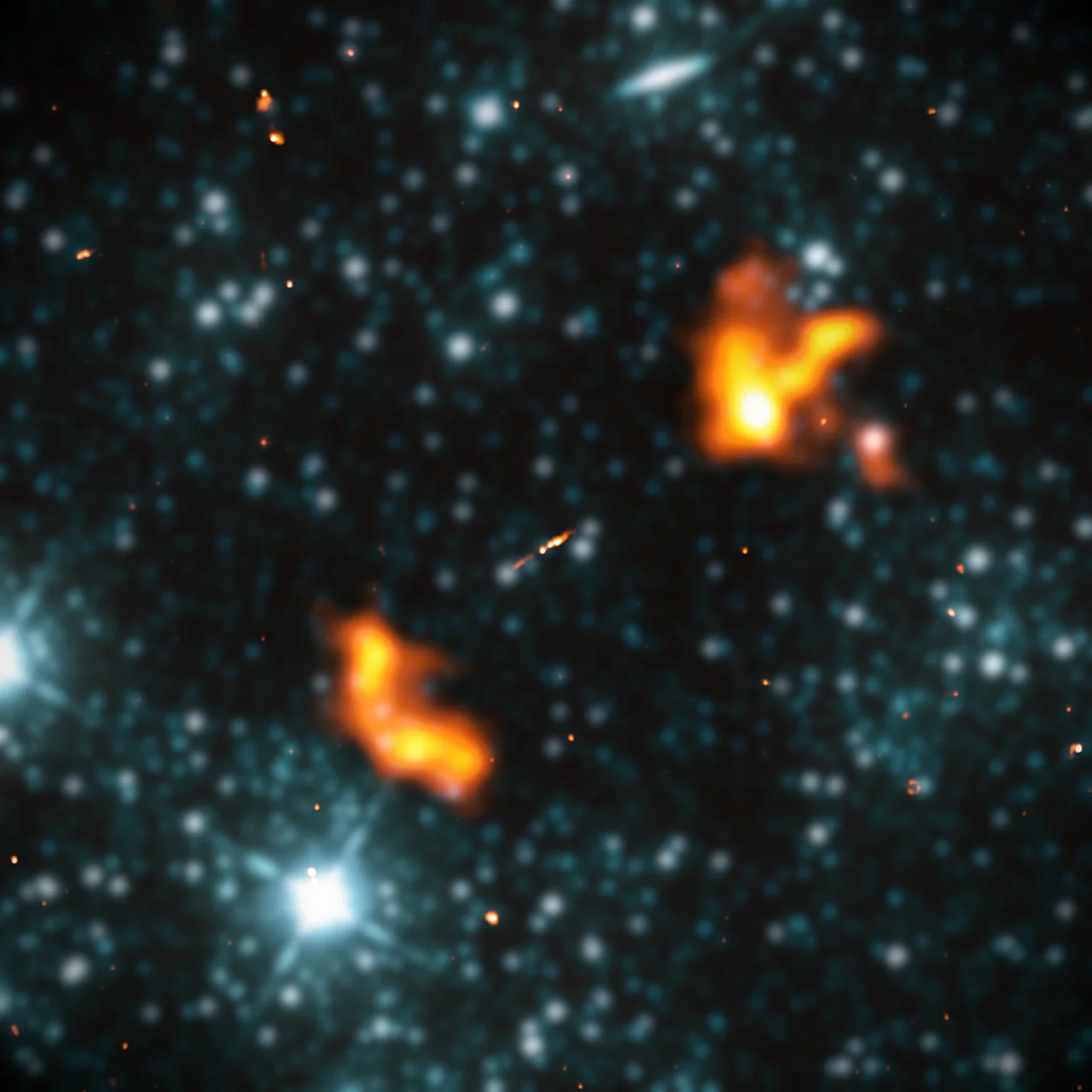
Picturing the Black Holes
In February 2021, LOFAR astronomers released an image that looked, at first glance, like a field of stars. It was not. Every white dot was an active supermassive black hole at the heart of a distant galaxy. Twenty-five thousand of them. Together they covered just two percent of the sky. A second survey, published a few years later, sharpened those same regions to a resolution finer than anyone had achieved at low radio frequencies. From a Dutch peat bog, researchers were essentially producing the deepest map of the violent, magnetized, mostly invisible universe ever made at these wavelengths.
Listening for the First Light
LOFAR's most ambitious target is also its most poetic. After the Big Bang, the universe spent a few hundred million years as a dark, neutral fog of hydrogen. Then the first stars and galaxies switched on, and their ultraviolet light tore that fog apart, ionizing it. The 21-centimeter glow of that primordial hydrogen, stretched by cosmic expansion into LOFAR's frequency window, carries the signature of the moment the cosmos first lit up. The signal is buried under foregrounds thousands of times brighter. Catching it would be like hearing a single match strike during a thunderstorm. The Dutch array, painstakingly, is trying.
Where the Country Goes Quiet
Drenthe is a low, flat province of canals, heathland and prehistoric stone tombs called hunebedden, dropped by glaciers and arranged by Stone Age farmers. It is one of the quietest corners of the Netherlands, both physically and electromagnetically, which is precisely why ASTRON put the core station here. Queen Beatrix opened LOFAR officially on 12 June 2010, and regular observations began at the end of 2012. From the air the central superterp looks like a faint geometric flourish stamped into the peat. From space it looks like nothing at all. From the universe, it looks like an ear.
From the Air
Located at 52.91 N, 6.87 E in the Dutch province of Drenthe, near the village of Exloo. Best viewed from 3,000 to 5,000 feet on clear days; from cruise altitude the core appears as a faint geometric pattern of low embankments and gravel tracks set in heath and pasture. Nearest airports: Groningen Airport Eelde (EHGG) about 35 km northwest, Munster/Osnabruck (EDDG) about 100 km southeast. The wider area is a designated radio-quiet zone; aircraft electronics are not affected, but ground-based transmitters are tightly regulated.
Nearby Stories
- Veendam 1.7 km away
- Dalfsen Train Crash 6.3 km away
- Nuis, Netherlands 7.4 km away
- Drenthse Veenkolonien 8.8 km away
- Hans Philipp 9.8 km away
- Börger 13 km away
- Leer, Lower Saxony 17 km away
- Rheine 31 km away