Nuis, Netherlands
Several million archaeological finds from across the three northern provinces of the Netherlands sit in climate-controlled storage in a village of 670 people. The Northern Archaeological Depot occupies the site of what was once Camp Nuis, a labor camp opened in 1941 by the Dutch Labor Service under German occupation. After the war the camp held collaborators awaiting trial, then juvenile prisoners, then Ambonese families displaced from Indonesia in 1951. The barracks came down after 1964. Now, on that same patch of Groningen sand, a low building keeps the bones and pottery shards and bronze pins of the north safe, while curators ship them out on loan to museums in Leeuwarden, Groningen, and Assen.
The Ridge and the Ditches
Nuis sits on a Geest, a low ridge of sandy soil that the last ice age left behind when it pushed bands of glacial debris across the northern Netherlands. Around the 10th century, people came back to settle this slightly higher ground and began carefully cutting away the surrounding peat for fuel. What they made over the next thousand years is a bocage landscape: every field rimmed with ditches and small canals, the plots stitched into a quilt of green and water that still defines the southern Westerkwartier today. The almost-twin village of Niebert presses against Nuis from the east. They share an axis, share a flag, and are sometimes called Nuis-Niebert as a single hyphenated entity, though the two stubbornly remain separate places with separate churches.
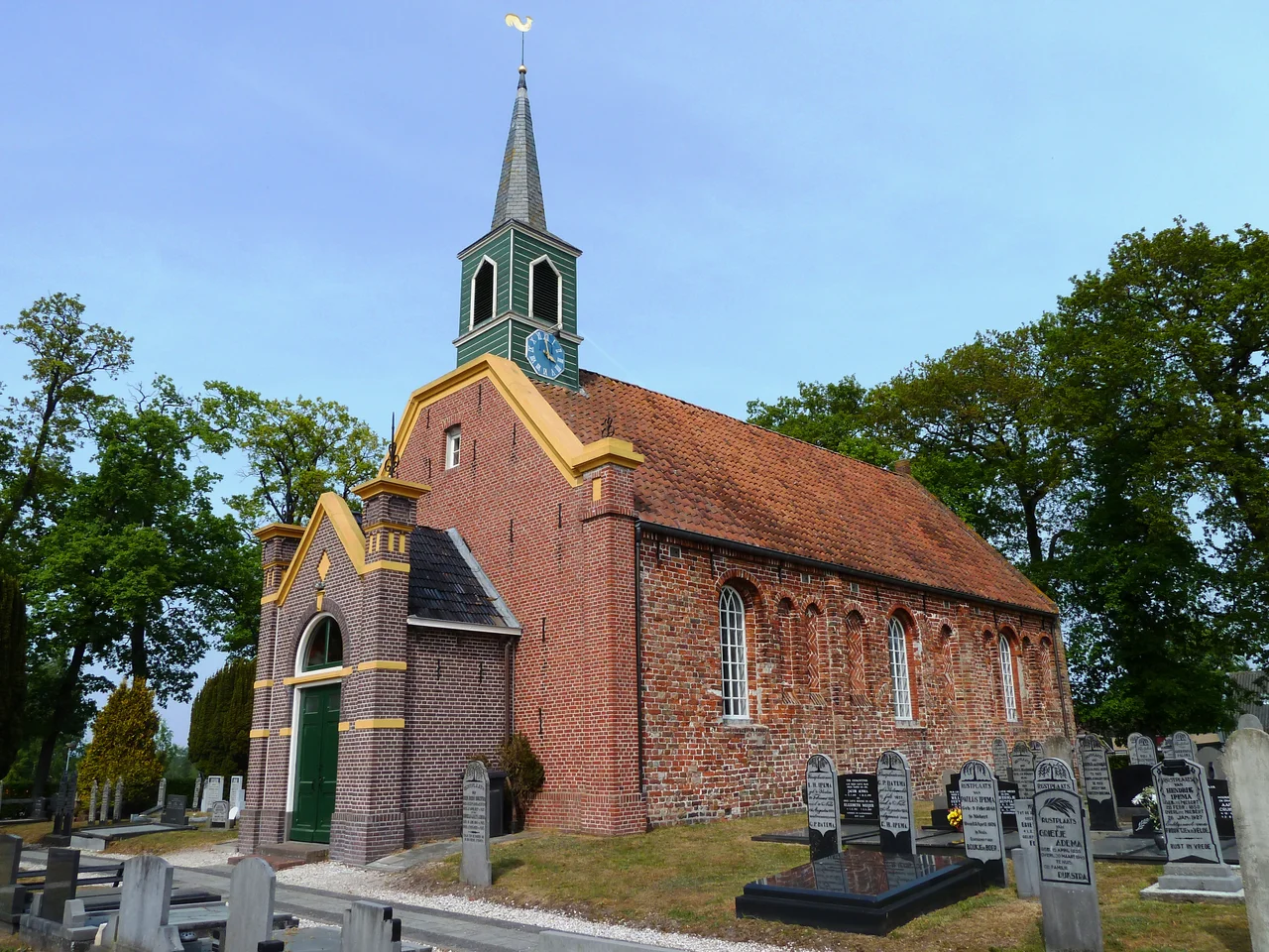
A Rare Romano-Gothic
The Reformed church on the west side of the village stands on a raised mound that is older than the building itself, a kunstmatige terp built up in centuries when high water was a serious risk this far inland. The church on top of it dates from the 13th century and was built in Romano-Gothic style, a transitional architecture that is unusual in this part of Friesland and Groningen. Inside hang twelve funerary hatchments belonging to the Van Teyens and Fockens families, the landed gentry who lived in the borg at the village's southwest edge. Each painted board records a death and a coat of arms, dark wood against whitewashed walls, the kind of object that turns a country church into a quiet record of who used to matter here.
Coendersborg and Its Forest
The Coendersborg, the moated manor house just southwest of the village, dates in its present form to 1813 and grew out of three medieval farms, including the Fossemaheerd that gave the estate its earliest name. The grounds around it were planted in the 20th century with conifers and deciduous trees in the English landscape tradition, with curving paths and small clearings meant to feel discovered rather than designed. Today the Groninger Landschap Foundation owns the woods and keeps them open to walkers and cyclists. The agricultural museum that once filled the borg's barn moved in 2012 to a renovated farm to the east, locally known as Kimm's farm, where the front rooms now do double duty as a holiday rental.
Camp, Depot, and What Stayed
The 1941 labor camp on the village edge is the part of Nuis's history that does not appear in cycling brochures. Built under occupation, used by the Dutch Labor Service to put unemployed men to work on land reclamation and ditch digging, it became after the war a place to hold Dutchmen accused of collaborating with the Germans. Then it housed juvenile prisoners. Then, after 1951, Ambonese soldiers and their families, brought from Indonesia after Dutch withdrawal and given barracks like these scattered across the rural north while the government figured out what permanent housing would look like. The camp came down after 1964. In 2016 a former barrack turned up in nearby Jonkersvaart, still standing as somebody's shed, and the village began a quiet campaign to bring it home. The Northern Archaeological Depot now occupies the camp's footprint, holding what survives of much older settlements while sitting on the foundation of a very recent one.
From the Air
Coordinates 53.151N, 6.304E. Best viewed from 2,000-4,000 ft AGL, where the bocage pattern of small fields stitched together by ditches becomes legible from the air. The raised church mound on the west side of Nuis catches morning light; the Coendersborg woods show as a darker green patch southwest of the village. Groningen Eelde (EHGG) is 25 km east, Drachten (EHDR) 20 km southwest. Watch for paragliders in summer over the Westerkwartier's open grain fields.
Nearby Stories
- Foxhol 2.8 km away
- Ernst-Wilhelm Modrow 5.6 km away
- Drenthse Veenkolonien 7.1 km away
- Schiermonnikoog 7.6 km away
- Aylvapoldermolen 9.5 km away
- Eemshaven Railway Station 10 km away
- Low-Frequency Array 13 km away
- West Sole Gas Field 297 km away