
Mabilafu
Four families own the land at Mabilafu, but for generations that ownership has meant something closer to stewardship than possession. Under customary law, the families who hold the soil are obliged to share it with those who do not, so that anyone in the village can plant, harvest, and feed a household. Land here behaves less like private property and more like a commons. Then, in 2010, a sugarcane company arrived, and the old arrangement began to come apart.
Where the Road Meets the River
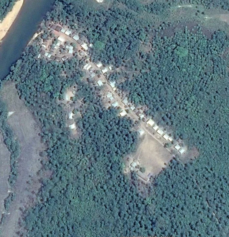
Mabilafu sits about 110 kilometers east of Freetown and 30 kilometers southwest of Makeni, on the bank of the Rokel, the longest river in Sierra Leone. A single dead-end dirt road runs down toward the water at roughly a right angle, then splits as it nears the riverbank. The lower village, by the river, is the older half; the upper village, with its newer houses, climbed the slope as the population grew. In 2013, around 140 houses held close to a thousand people, most of them Temne and Muslim. Yet older currents run beneath the surface. Animist belief endures, and the Poro society, the men's secret order that shapes initiation and authority across much of Sierra Leone, still threads through daily life. At the riverside heart of the village stand the mosque and a new community center, an open-sided cement building with a zinc roof, a small stage, and wooden benches where the village gathers to decide its affairs.
Four Quarters, Four Families
The village divides into roughly four quarters, one for each of the landowning families. This is not just geography; it is the architecture of belonging. Customary law, developed locally and woven into the culture, governs who may use the land and on what terms. The owning families could not simply hoard their holdings. They were bound to grant access to landusers, neighbors who held no title but still needed to farm. Through these interlocking rights, the soil functioned as a common-pool resource, sustaining owners and non-owners alike. The system had its strains, and food was never guaranteed, but it spread both risk and reward across the whole community. Near the end of the upper village, an Evangelical Mission primary school enrolled 265 children from Mabilafu and surrounding hamlets in 2013, serving each of them a daily meal supplied by the World Food Programme.
When the Sugarcane Came
Mabilafu lies inside the boundaries of the Addax Bioenergy Project, a large-scale land deal that broke ground in 2010 and built an agro-ethanol factory that began operating in 2014 just beyond the village. Land was acquired for the plant, its infrastructure, and the sugarcane plantations that feed it. The company paid landowners an annual lease of roughly 35,000 leones per hectare and praised itself as a model of sustainable investment. But the money was thin against what was lost. It was not enough to replace the food the land once produced. And it flowed only to the title-holding families, not to the landusers, who under the old custom had also depended on those fields and now received nothing at all. A commons had been quietly converted into a contract, and the people the custom protected were the ones the contract forgot.
The Promise and the Reckoning
The company offered remedies. A Farmer Development Program promised to modernize agriculture and raise food production, and new wage jobs promised cash to replace what the fields had given. Both faltered. Harvests under the new methods were poor, and the program failed to take root in the local context. The jobs proved precarious, mostly temporary, low-paid, and too few to cover everyone who had lost land. People improvised, clinging to subsistence plots or building small informal trades, but those who had been poorest before often could not adapt at all. The work, however shaky, still drew newcomers, mostly men chasing employment, and the village swelled. Mabilafu's story is small in scale and global in pattern: a village asked to trade a way of life it understood for promises it could not bank on.
From the Air
Mabilafu lies at 8.70°N, 12.23°W, on the bank of the Rokel River in Tonkolili District, northern Sierra Leone. The river itself is the clearest navigation feature, winding southwest toward the coast; the Addax agro-ethanol factory and surrounding sugarcane plantations form a distinct geometric clearing nearby. The nearest major airport is Freetown-Lungi International (GFLL), roughly 110 km west. Best viewed from low altitude in the clear, dry-season air between December and April; the rainy months bring haze and heavy cloud over the river valley.
Nearby Stories
- Operation Barras 23 km away
- Lake Sonfon 33 km away
- Tokeh, Sierra Leone 47 km away
- The Loma Mountains: Sierra Leone's Rooftop and Last Refuge 74 km away
- Outamba-Kilimi National Park 91 km away
- Tiwai Island 103 km away
- Kindia 123 km away