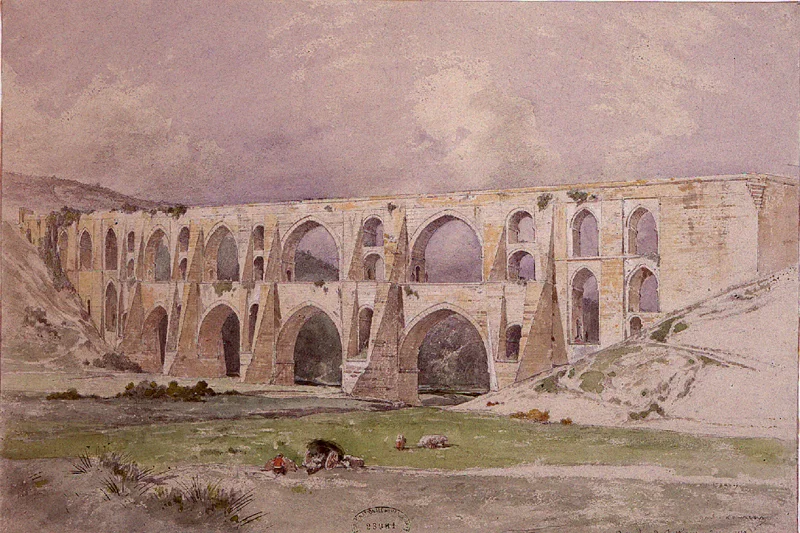

Mağlova Aqueduct
Historian Semavi Eyice chose his words carefully when he called the partial submersion of the Mağlova Aqueduct "the greatest crime in terms of Turkish art history." He was not exaggerating. When the Alibeyköy dam was built in the 20th century, rising waters swallowed a quarter of a structure that Mimar Sinan — the same architect who raised the Süleymaniye Mosque in Istanbul and the Selimiye Mosque in Edirne — had spent seven years designing and building at the command of Suleiman the Magnificent. The aqueduct is still there, still standing, still carrying water. It is also partially drowned.
Sinan's Other Masterpiece
Mimar Sinan is remembered above all for his mosques: the Süleymaniye completed in 1557, the Selimiye in Edirne completed in 1575, soaring domes and slender minarets that became the visual signature of Ottoman civilization at its height. Less celebrated is the fact that Sinan was also the empire's chief engineer for infrastructure, responsible for water systems, bridges, and caravanserais across an enormous territory. The Mağlova Aqueduct — also called Muallakkemer, meaning "suspended arch" — was built between 1555 and 1562 to carry fresh water from the Belgrade Forest springs into Constantinople. Suleiman's water supply project was a massive undertaking, and the Alibey valley crossing was its most technically demanding span. Sinan solved it with a two-tiered arcade 35 meters high and 257 meters long.
The Architecture of the Arches
The structural logic of the Mağlova Aqueduct is worth understanding because it is not simply a matter of piling stone upon stone. The lower tier carries eight large arches — four of them wider than the others at 18.4 meters across — which bear the weight of the upper tier's eight smaller arches, the middle four of which span 13.4 meters each. This graduated system distributes load efficiently down through the piers to the valley floor. The variation in arch widths is not arbitrary; it reflects the terrain of the Alibey Creek valley and the need to span its irregular width without compromising structural integrity. One year after completion, in 1563, floodwaters damaged the structure and Sinan's team repaired it the same year. It has continued carrying water to Istanbul in the centuries since.
The Dam That Came Later
The Alibeyköy reservoir, created when the Alibey Creek was dammed in the 20th century, is both the aqueduct's context and its partial undoing. The dam lake now covers roughly a quarter of the aqueduct's base and lower piers, fluctuating with the water level. During dry periods, when the reservoir drops, more of the original structure is revealed — the submerged stonework emerging from the water like something being slowly uncovered rather than built. This partial visibility has a strange quality: you see the upper portion clearly, striding across the landscape with confident grandeur, while the lower section disappears into opaque green water. Semavi Eyice's outrage was specifically about this — that a structure he considered equal in architectural importance to the great mosques was being allowed to deteriorate, partially hidden, without adequate protection.
Stone, Coin, and Memory
In 2005, Turkey minted 1,250 commemorative coins worth 20 Turkish lira each bearing the image of the Mağlova Aqueduct — a small acknowledgment of the structure's cultural weight. The number is telling: only 1,250 coins for a monument that stands in the same artistic league, according to scholars of Ottoman architecture, as structures known worldwide. The aqueduct sits near Cebeci village in the Sultangazi district of Istanbul, accessible but not heavily touristed. Those who make the trip see something remarkable: Roman engineering traditions refracted through Islamic Ottoman practice, stone arches built to last centuries proving exactly that. The water still flows above. The reservoir holds below. And Sinan's math, worked out over seven years in the mid-16th century, continues to hold everything up.
From the Air
The Mağlova Aqueduct is located at approximately 41.136°N, 28.893°E in the Sultangazi district of Istanbul, spanning the Alibey Creek valley near Cebeci village. From the air, the two-tiered arcade is visible crossing the Alibeyköy reservoir, with the lower portion partially submerged in the dam lake. The surrounding Belgrade Forest provides orientation — the aqueduct lies at the southern edge of the forested water-catchment area. Nearest major airport is Istanbul Airport (LTFM), approximately 20 km to the north. Recommended viewing altitude 2,000–3,500 feet to appreciate the full span across the valley.
Nearby Stories
- Kınalıada 6.2 km away
- Şile Castle 7.8 km away
- Second Battle of Çatalca 8.9 km away
- Hereke 20 km away
- 2025 Istanbul Earthquake 25 km away
- Battle of Constantinople (922) 61 km away
- Januarius MacGahan 87 km away
- Edirne 160 km away