The Mahakam: Borneo's River of Kingdoms and Dolphins
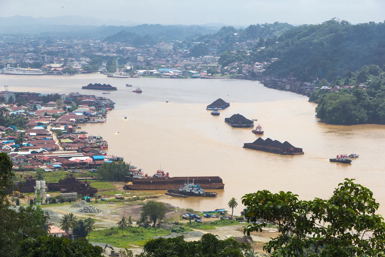
The fishermen on the middle Mahakam call them pesut. Freshwater Irrawaddy dolphins, barely eighty left, surfacing in brown water between coal barges and fishing nets. That a critically endangered cetacean still breathes in one of Indonesia's busiest industrial waterways tells you everything about this river: the Mahakam has always held contradictions together. It cradles ancient kingdoms and oil fields, pristine peatland and heavy-metal pollution, thirty shallow lakes and three billion barrels of petroleum, all along 980 kilometers of equatorial Borneo.
Where the River Begins
The Mahakam rises at Cemaru, 1,681 meters up in the mountainous heart of Kalimantan, where the pre-tertiary spine of Borneo divides Indonesian and Malaysian territory. From there it cuts southeast through ancient rock, meeting the Kedang Pahu tributary at Muara Pahu before entering the flat tropical lowlands of the middle Mahakam. Here the river slows and spreads into a labyrinth of thirty shallow lakes connected by narrow channels, surrounded by vast stretches of peatland. The Semayang and Melintang lakes anchor this system, their levels swinging from barely half a meter in the dry season to seven meters during the rains. Downstream, three more major tributaries join -- the Belayan, Kedang Kepala, and Kedang Rantau -- before the Mahakam fans out into a delta 65 kilometers wide, emptying into the Makassar Strait. It is the third-longest river in Borneo, after the Kapuas and the Barito, and the largest in East Kalimantan, draining a catchment of roughly 77,100 square kilometers.
The Cradle of Kutai
Long before the Dutch drilled for oil, the Mahakam gave rise to what is widely considered the oldest kingdom in the Indonesian archipelago. Kutai Martadipura, a Hindu kingdom founded by Mulawarman around the 4th century AD at Muara Kaman, left behind seven stone yupa inscriptions carved in Pallawa script and Sanskrit. These pillars remain among the earliest written records in Southeast Asian history. A second Kutai kingdom, Kutai Kartanegara, emerged around 1300, established by Javanese settlers near the river's mouth. By 1565, Islam had reached the kingdom through two Javanese preachers, Tunggang Parangan and Ri Bandang, transforming the spiritual landscape of the entire basin. The Dayak people, Kalimantan's indigenous inhabitants, have lived along these banks far longer than any kingdom's records can trace. Since the 1970s, Indonesia's transmigration program resettled families from overcrowded Java, Bali, and Madura to the Mahakam region. By 1973, migrants were working nearly a quarter of all cultivated land in East Kalimantan.
Black Gold Beneath the Delta
Geological surveys began along the lower Mahakam in 1888. Nine years later, an exploration well struck oil at just 46 meters depth on the Louise structure, and by 1898 production was flowing. A small refinery went up in nearby Balikpapan. Today the Kutai Basin ranks as one of the world's major hydrocarbon provinces, holding more than eleven billion barrels of oil equivalent in proven reserves. The delta alone contains around three billion barrels of oil and thirty trillion cubic feet of natural gas. Major discoveries cascaded through the 1970s and 1980s: Bekapai in 1972, the giant Handil and Nilam fields in 1974, Tunu in 1977. The wealth extracted from beneath this river has shaped modern East Kalimantan, funding the provincial capital Samarinda -- which sits just 48 kilometers from the river's mouth -- and fueling decades of economic growth. It has also exacted a cost.
A River Under Pressure
Logging, coal mining, and oil extraction have polluted the Mahakam at what researchers describe as an alarming rate. Water pollutant levels rose sharply between 2009 and 2011. A 2015 study found lead concentrations in Mahakam fish exceeding safe levels by more than a thousand times, alongside dangerous quantities of copper, zinc, and cadmium. Despite this, officials have claimed the water remains safe for consumption -- a statement that strains credibility. The middle Mahakam's fishing grounds still produce 25,000 to 35,000 metric tons annually, sustaining communities for whom fishing is the primary livelihood. Meanwhile, the delta's mangroves are slowly recolonizing degraded areas, trapping sediment and rebuilding ecosystems. BirdLife International has designated 160,000 hectares of the delta as an Important Bird Area, home to 298 species including five found nowhere else on Earth: the dusky munia, Bornean whistler, Bornean peacock-pheasant, Bornean blue-flycatcher, and Bornean bristlehead.
The Last Pesut
The Mahakam's Irrawaddy dolphins represent one of only three riverine populations of this species anywhere in the world, alongside those in the Mekong and the Irrawaddy itself. Roughly eighty individuals survive in a 93-kilometer stretch of the middle Mahakam between Kutai Kartanegara and West Kutai districts. Their refuge is bracketed by coal barges upstream and fishing nets downstream. Conservation efforts are intensifying: Kutai Kartanegara's district government has sought to designate its section of the river as a hydrological park, and authorities are moving to ban unsustainable fishing methods within the dolphin sanctuary. Whether these measures arrive in time remains an open question. The pesut have outlasted kingdoms and colonizers, oil booms and bridge collapses. Whether they can outlast the twenty-first century depends on choices being made right now, in boardrooms and fishing boats along the Mahakam.
From the Air
The Mahakam River mouth and delta are located near 0.80S, 117.46E. The river is a prominent visual feature stretching roughly 980 km from the Borneo highlands to the Makassar Strait. Samarinda (WALS / SRI), the provincial capital, sits 48 km upriver from the mouth. The delta fans out 65 km wide and is clearly visible from cruising altitude. Best viewed at 5,000-15,000 ft for the middle lakes region. The equatorial climate means frequent cloud cover; morning flights offer the best visibility. Nearby airports include Sultan Aji Muhammad Sulaiman Airport (WALL) at Balikpapan.
Nearby Stories
- The Invisible Wall of Makassar Strait 6.6 km away
- The Bridge That Tried to Be Golden 12 km away
- The Airfield That Vanished 20 km away
- The Vanishing Green Heart of Borneo 30 km away
- Equally Low: Samarinda and the Mahakam 50 km away
- Borneo's Oil Capital 78 km away
- Stone Faces in the Cloud Forest 193 km away
- Cutting the Orchid in Half: The Proposed Sulawesi Canal 213 km away