The Vanishing Green Heart of Borneo
From above, the scars are unmistakable. Where satellite imagery from the 1970s showed an unbroken canopy of green stretching across the third-largest island on Earth, today's images reveal a patchwork of palm oil plantations, bare earth, and thin strips of surviving forest clinging to ridgelines and river corridors. Borneo -- divided between Indonesia, Malaysia, and Brunei -- once produced more timber than Africa and the Amazon combined. That statistic sounds like a boast. It is an epitaph.
An Unprecedented Pace
Industrial deforestation began in earnest during the 1960s, but it was the 1980s and 1990s that redefined what destruction could look like. Logging in Borneo during those decades was among the most intensive the world has ever seen, with 60 to 240 cubic meters of wood harvested per hectare -- compared to roughly 23 cubic meters per hectare in the Amazon. In Kalimantan, the Indonesian portion that makes up roughly 73% of the island, some 80% of lowland forests were handed over to timber concessions, including virtually all of its mangrove forests. President Suharto distributed vast tracts of forest to cement political relationships with army generals. The logging roads that followed opened remote lands to settlers and developers, and if all the roads built between 1990 and 2009 in Malaysian Borneo and Brunei were laid end to end, they would circle the Earth nine times. Half of the world's annual tropical timber procurement now comes from this single island.
Where the Peat Burns
Beneath Borneo's southern forests lies something invisible but enormously consequential: peat. Ten to twelve meters deep in places, this waterlogged layer of partly decayed plant material is one of the planet's great carbon stores. In 1996, Indonesia's Mega Rice Project attempted to convert one million hectares of this peat swamp forest into rice paddies. Irrigation canals were dug, trees removed, and the project was heralded as a solution to the nation's food shortages. It failed catastrophically. The canals drained the peat rather than irrigating it, leaving bone-dry organic matter that caught fire in every dry season. The 1997-1998 fires, intensified by an El Nino drought, sent smoke across Brunei, Malaysia, Singapore, and Indonesia, causing respiratory problems for half a million people. The fires released enormous quantities of CO2 into the atmosphere and left behind acidified rivers where fish catches plummeted. The government abandoned the Mega Rice Project, but the damage continues. Drying peat still ignites regularly, and fires set for land-clearing on palm oil plantations spread into adjacent forest with devastating ease.
Sacred Forests, Silenced Voices
For the Dayak people, indigenous to much of Borneo, the forest is not merely a resource -- it is the foundation of ethnic identity, spiritual practice, and daily survival. The Dayak who follow Kaharingan Hindu beliefs hold that every living being carries a gana, a spirit, within it. To enter the sacred Pahewan forests requires a manyanggar ceremony, a formal request to the spirits for permission. Plantations now press against these sacred boundaries daily. Across Malaysian Borneo, indigenous communities have watched logging companies enter their ancestral forests without free, prior, or informed consent. They have responded with peaceful demonstrations, social media campaigns, and physical blockades of logging roads -- sometimes with success, though questions about how and why licenses were granted without community agreement remain unanswered. The pattern repeats across the island: communities whose relationship with the forest stretches back centuries find themselves confronting industries whose timelines are measured in quarterly profits.
Green Shoots in Scorched Earth
Against this backdrop, reforestation efforts have begun to show what recovery might look like. The Borneo Orangutan Survival Foundation purchased nearly 2,000 hectares of degraded land in East Kalimantan -- terrain so damaged it was covered in nothing but alang-alang grass -- and began replanting hundreds of indigenous tree species under the project name Samboja Lestari. By 2006, more than 740 species had been planted. In the Lamandau Wildlife Reserve, the Orangutan Foundation has planted over 60,000 saplings to restore fire-damaged areas. Near the villages of Laman Satong and Sedahan Jaya, bird populations have increased by 27% per year over five years of reforestation monitoring. In Sabah, the Sow-A-Seed project has been working since 1998 to reforest 18,500 hectares using natural regeneration, cluster planting, and row planting -- and orangutans, elephants, and wildcat species have been seen returning to the area. These projects remain small against the scale of loss. But they demonstrate something the timber and palm oil industries prefer not to acknowledge: that forests, given patience and care, can begin to come back.
A Global Reckoning
Since 2020, 92% of newly deforested land in Borneo has been converted into plantations within a year -- a statistic that reveals how tightly deforestation is now linked to industrial agriculture rather than subsistence farming. The Bornean orangutan became critically endangered in 2016, the same year deforestation reached an all-time high. Palm oil plantations continue encroaching on the last remnants of primary rainforest, and an estimated 88% of logging in Indonesia remains illegal in some form. But the crisis is not solely Indonesia's or Malaysia's to solve. The forests of Borneo function as carbon sinks, biodiversity reservoirs, and climate regulators for the entire planet. Expecting a few indebted nations to shoulder the cost of preserving a global public good is, as conservation scientists have argued, unreasonable. The forests of Borneo belong to the world in consequence, if not in title. What happens to them happens to all of us.
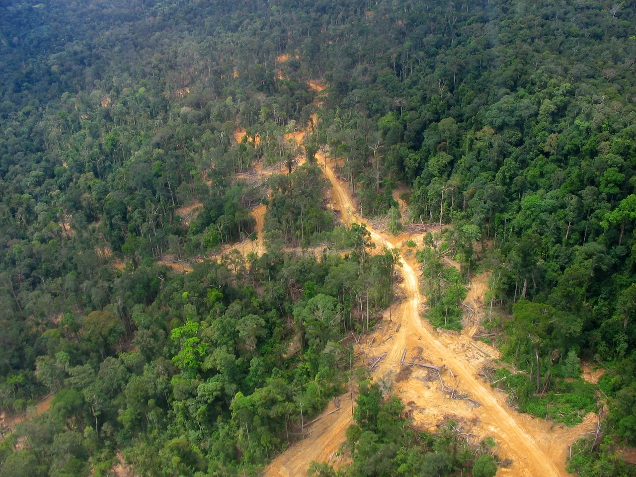
From the Air
Centered at approximately 1.05S, 116.99E in East Kalimantan, Indonesian Borneo. The contrast between intact forest and palm oil plantations is visible from cruising altitude, particularly along river corridors and coastal lowlands. Nearest major airport is Sultan Aji Muhammad Sulaiman Sepinggan International Airport (WALL/BPN) at Balikpapan. The patchwork of deforestation is most dramatically visible when flying along the eastern coast of Kalimantan at altitudes of 15,000-25,000 feet, where the grid pattern of plantation roads contrasts sharply with surviving forest blocks.
Nearby Stories
- The Last Beach 6.9 km away
- The Mahakam: Borneo's River of Kingdoms and Dolphins 20 km away
- The Bridge That Tried to Be Golden 31 km away
- Badak LNG: Borneo's Gas Giant 91 km away
- Sixty Seconds Over Banjarmasin 171 km away
- The Ground Beneath Mamuju 258 km away
- Oil, Empire, and the Fight for Borneo 275 km away
- The Million-Hectare Mistake 282 km away