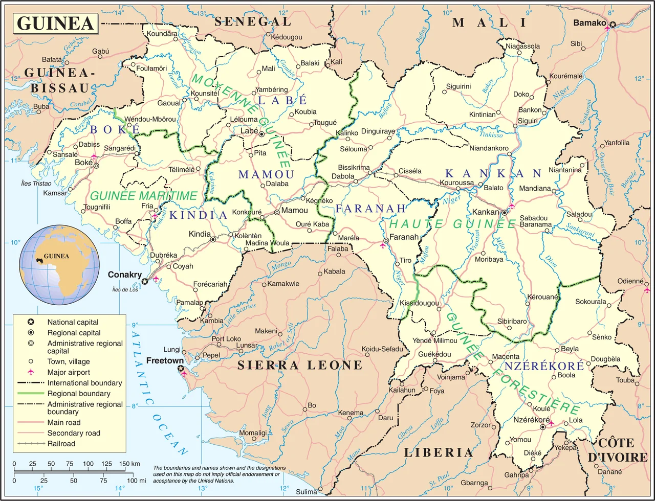

Maritime Guinea
The coastline here does not draw a clean line. Rivers that began as cold springs high in the Fouta Djallon arrive at the Atlantic exhausted and braided, and the sea reaches up to meet them, flooding the lower valleys until land and water stop arguing about where one ends. The result is a coast of drowned river mouths, or rias, fringed with mangrove and laced with tidal channels that fill and empty twice a day. This is Maritime Guinea, also called Lower Guinea or Basse-Guinée, the westernmost of the country's four natural regions, the place where the highlands finally come down to the ocean.
The Drowned Edge
Stand at the shore and the geography reads as a long, gentle ramp tilted toward the sea. The coastal plain is wider in the south than the north, and behind it the green wall of the Fouta Djallon plateau rises like a held breath. From that plateau the rivers come west and never stop: the Fatala, the Konkouré, the Kolenté, all born in the high country and all spending themselves in the Atlantic. Where they meet salt water, the land gives way to inlets, tidal marshes, and estuaries thick with mangrove. Offshore, islands scatter into the haze. Conakry, the capital, sits on Tombo Island and the long finger of the Kaloum Peninsula, a city built on the very seam between continent and sea.
Rain as a Season
Conakry is one of the wettest capitals on Earth, and the calendar here is written in water. The dry season runs from November through March; the wet season arrives in April and does not relent until October. The heaviest rain falls in June, when the Inter-Tropical Convergence Zone swings overhead and the sky simply opens. About 4,300 millimeters fall on Conakry in an average year, more than four meters of water, while the temperature barely shifts from a steady 27 degrees Celsius. The red soils underfoot, laterite stained by iron, tell the rest of the story: this is a land scrubbed and saturated, where rust-colored earth meets a gray-green sea.
Coast of Many Peoples
Maritime Guinea has never belonged to a single people. The Baga live along the coast itself, a people long tied to rice paddies wrested from the mangrove and to a sculptural tradition whose carved masks and headdresses became famous far beyond Guinea. South toward Conakry and across into Sierra Leone, the Susu predominate, and their language carries across the markets and fishing quays of the lowlands. In the north, where the plain narrows and the highlands press closer, the Fulani hold sway, the same herding people whose ancestors built a state in the mountains above. Three peoples, one wet and shifting coast, all of them shaped by the rivers coming down.
Where the Land Breathes
The defining ecosystem here is the mangrove, and to call it scenery undersells it. Mangrove forests are nurseries, storm walls, and carbon sinks at once, and Guinea's coastal estuaries hold some of West Africa's most extensive stands. Inland from the salt, the Guinean forest-savanna mosaic spreads its patchwork of woodland and grass, while pockets of lowland rainforest cluster around Conakry and southward toward Liberia. At low tide the mangrove flats glisten and the air smells of brine and rot and growth. At high tide the channels brim and the whole coast seems to lift. This is land that breathes with the moon.
From the Air
Maritime Guinea spans the Atlantic coast of western Guinea, centered near 10.54 N, 13.38 W. Conakry's Ahmed Sékou Touré International Airport (GUCY / CKY) sits on the Kaloum Peninsula. Approaching from the sea, look for the deeply indented ria coastline, the dark band of mangrove estuaries, and the green wall of the Fouta Djallon rising behind the plain. A cruising altitude of 8,000 to 12,000 feet gives the best read of the drowned river mouths and offshore islands. Expect heavy cloud and reduced visibility from April through October, with the worst in June; the dry season (November-March) offers the clearest coastal views.
Nearby Stories
- Pongo River (Guinea) 16 km away
- Kindia 23 km away
- Boké 34 km away
- Boké Museum 59 km away
- Operation Green Sea 74 km away
- Dalaba 87 km away
- Fugumba 99 km away
- Battle of Porédaka 160 km away