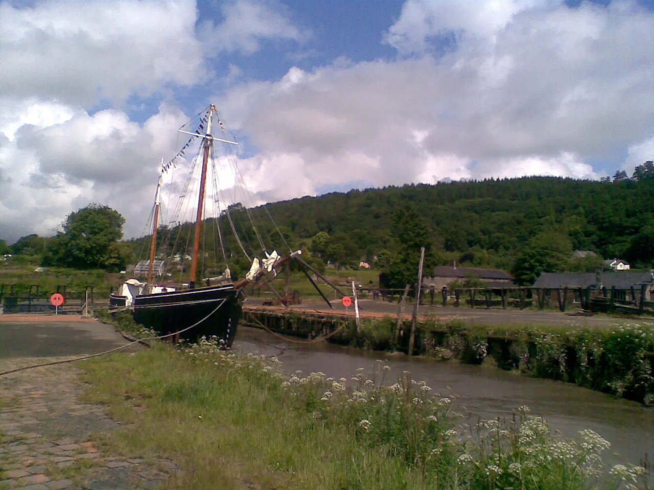

Morwellham Quay
Queen Victoria came to look at it in 1856. By then the small inland port on the steep wooded bank of the River Tamar was sending 30,000 tons of copper ore down to Plymouth every year, and would soon be the world's largest supplier of arsenic. Morwellham Quay - twenty-three miles inland from the open sea, fed by a 4.5-mile canal that included a 1.5-mile tunnel through solid rock and dropped its barges to the river on a water-wheel-powered inclined plane - had become, in one widely repeated phrase of the period, the richest copper port in Queen Victoria's empire. The phrase was earned. Morwellham was a marvel of Victorian industrial logistics built on top of a port that the monks of Tavistock Abbey had been using since the 10th century.
The Monks' Landing
Tavistock Abbey was founded in 961, a Benedictine house a few miles inland from the Tamar. The River Tavy, which runs past the abbey, was not navigable beyond its tidal limits, so the monks needed a quay on the Tamar to handle their goods. They chose a small pocket of flat ground on a sweeping bend of the river, where the bank gave way to deep tidal water and ships could come and go on the rise and fall of the sea. By the 12th century the quay was handling tin ore from Dartmoor. By the 13th, lead and silver had been added to the cargoes. The Benedictines themselves were dissolved by Henry VIII in 1539, but the quay they had established kept working, passing through the hands of secular landowners and continuing to carry the metals of the West Country to wider markets.
The Tavistock Canal and the Inclined Plane
By the late 18th century, the bottleneck was no longer the river but the road to it. Pack horses carried ore over rugged ground from the mines around Tavistock down to the quay, and the volume was outstripping what hooves could move. The answer was the Tavistock Canal, opened in 1817. The waterway ran 4.5 miles from Tavistock to a basin on the cliff above Morwellham. Most spectacularly, it bored straight through the ridge of Morwell Down in a 1.5-mile tunnel - work that took fifteen years and killed several of the navvies who drove it. From the basin on the cliff above the quay, barges had to descend 237 feet to the river. The solution was an inclined plane: an iron-railed slope down which the barges rolled on wheeled cradles, the descending weight raising empty barges on the other rail, all controlled by a waterwheel at the top. Once at the quay, the cargoes were transferred to seagoing ships.
Devon Great Consols
In 1844 a mine called Devon Great Consols, just four miles north of Morwellham, struck the largest copper lode then known in Europe. For nearly sixty years the mine poured its production down the hill to the quay. A second inclined plane was built specifically for this traffic. A new quay was added to handle the volume. At its peak, Morwellham was shipping 30,000 tons of copper ore each year, and the surrounding hills were stripped of timber to fuel the steam engines and smelters of the valley. Arsenic - extracted from arsenopyrite as a byproduct of the same workings, and increasingly valued for paints, pesticides, and pigments - became the second great export. By the late 19th century the works around the Tamar produced more arsenic than anywhere else in the world. Then, in 1901, the copper lode failed. By 1903 Devon Great Consols was finished. The mines closed, the population melted away, and the railways - which had reached the area in the 1860s - absorbed what little freight remained.
A Quiet Half-Century
After 1903 the quay fell silent. The canal tunnel was reconfigured to supply water to a small hydroelectric station and is still doing so today. The inclined planes were abandoned. The cottages of the quayside settlement decayed in the damp Devon air. The river still rose and fell on the tide, but the ships stopped coming. For most of the 20th century the place was a curiosity - an industrial fossil in a steep valley - until in 1970 a charitable trust began restoring it as an open-air museum. Victorian cottages were reopened. The 32-foot overshot waterwheel that once powered a manganese-crushing mill was set turning again. The assayers' offices, the schoolroom, the lime kilns, the Ship Inn, and the surviving Tamar sailing ship Garlandstone were brought back to working order. A battery-electric tramway was driven into a single level of the George and Charlotte copper mine.
World Heritage and Edwardian Farm
In July 2006 UNESCO inscribed the Cornwall and West Devon Mining Landscape on the World Heritage list, and Morwellham, with neighbouring Tavistock, became the easternmost gateway to that World Heritage area. The site is now an Anchor Point of ERIH, the European Route of Industrial Heritage. In 2009 Devon County Council withdrew its funding, the museum's operating trust went into administration, and the place looked likely to close for good. The owners of Bicton Park bought the site in April 2010 and reopened it later the same year. In 2009 and 2010 the BBC filmed its series Edwardian Farm at Morwellham, with three historians living and working on the site as their Edwardian predecessors would have done. The cameras left, but the farm they restored continues. The Tamar continues. The quay - older than the Norman Conquest by a margin of a century - is still there above the water that built it, listing toward the next century of weather.
From the Air
Morwellham Quay sits at 50.505N, 4.194W on the Devon (east) bank of the River Tamar, about 4nm south of Tavistock and 10nm north of Plymouth. Recommended viewing altitude 1,500-2,500 feet AGL. The Tamar threads obviously through a deeply cut wooded gorge; the quay shows as a cluster of buildings around a small dock on the broad inside bend at Morwellham. Just north of here, the Tavistock Canal tunnel exits the ridge of Morwell Down and the inclined plane scar still runs down to the river. Plymouth Sound and Tamar Bridge to the south are useful navigation references. Nearest airport Plymouth (EGHO) about 9nm south-southwest; Exeter (EGTE) about 30nm east-northeast. Mist commonly fills the valley early.
Nearby Stories
- Bodmin Moor 4.1 km away
- South Devon Railway sea wall 4.8 km away
- Tiverton Castle 12 km away
- Hope Cove Lifeboat Station 14 km away
- Caerhays Castle 20 km away
- Holsworthy 22 km away
- HMS Formidable (1898) 32 km away
- HMS Montagu 41 km away