
Mount Arrowsmith Biosphere Region
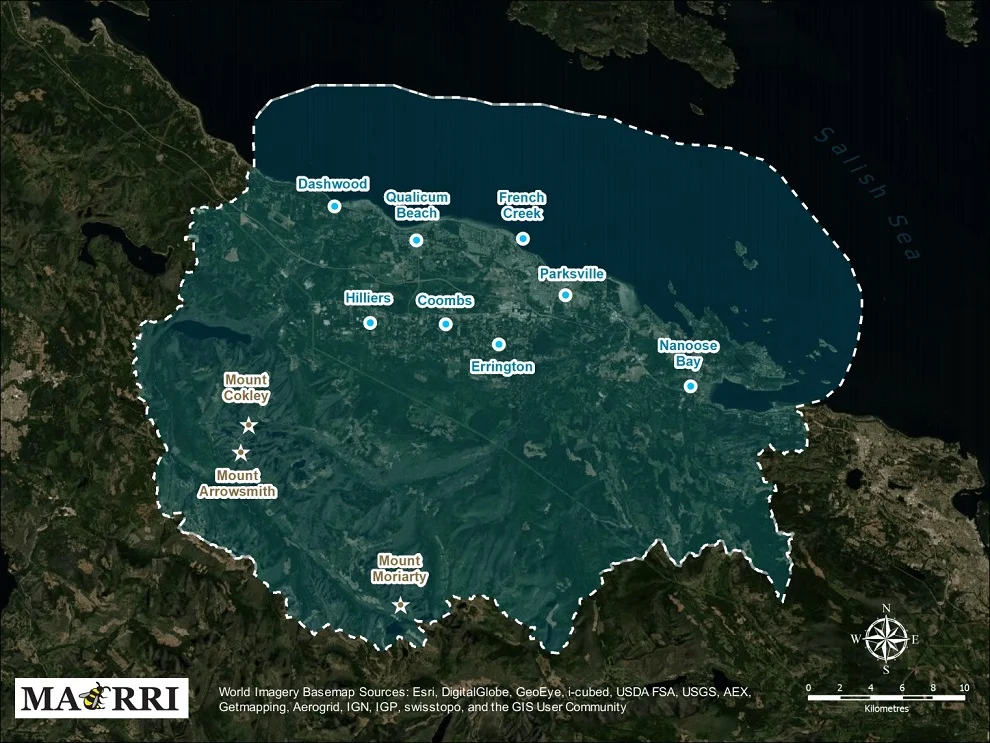
In 1925, from the summit of Mount Arrowsmith, Don and Phyllis Munday looked out across the Strait of Georgia and picked out the far-off summit of Mount Waddington. It is the kind of thing this mountain has always been good for - not difficulty so much as vantage. At 1,819 metres it is the highest peak east of Port Alberni, a basalt tower standing where the Vancouver Island Ranges lean toward the sea, and from its top you can trace the whole shallow bowl of country that now carries its name: 118,592 hectares designated by UNESCO in 2000 as the Mount Arrowsmith Biosphere Region.
A Reserve That Is Growing Back
Most biosphere reserves are argued for on the strength of what has survived. This one was argued on the strength of what is returning. The designation protects a large second-growth coast Douglas fir ecosystem in the watersheds of the Little Qualicum and Englishman rivers, land whose original old-growth forest was cleared in the early 1900s and has since matured back into working forest. The threat the designation named was not the saw but the subdivision - development creeping up Vancouver Island's crowded east coast toward watersheds that hold the drinking water, the salmon and the shade. It is a quietly radical premise: that a recovering landscape, imperfect and logged over and threaded with roads, is worth international standing precisely because it is still recoverable.
Two Rivers Off One Shoulder
The Little Qualicum and the Englishman both drain the northeastern slope of Mount Arrowsmith, and they carry the region's geography downhill in a hurry. Nine protected areas sit inside the biosphere region, and reading the list is a decent itinerary in itself: Arbutus Grove, Englishman River Falls, Little Qualicum Falls, MacMillan, Rathtrevor Beach and Spider Lake provincial parks; Englishman River Regional Park; Mount Arrowsmith Massif Regional Park; and the Qualicum National Wildlife Area. From alpine rock to waterfall canyon to estuary flats to the long sand of Rathtrevor Beach, a single watershed's worth of country runs through nearly every habitat the island has to offer.
Jagged Points Facing Upward
The Tseshaht name for the mountain is kal-ka-c'alh - Jagged Points Facing Upward - which describes the summit ridge better than the English one does. Captain George Henry Richards attached the name Arrowsmith around 1853, honouring the London cartographers Aaron Arrowsmith and his nephew John, whose charts were the working tools of the survey. The botanist John Macoun made the first recorded ascent in 1887, guided by Qualicum Tom, a local Indigenous guide, and his son James Thomas, who knew the route up the massif long before it had a survey name. Three biogeoclimatic zones stack up the mountainside, running from coastal western hemlock forest at the base to alpine tundra near the top, so a single day's climb passes through more ecological change than a long drive would. In September 2009 the 1,300-hectare Mount Arrowsmith Massif Regional Park was established to give the summit itself formal protection.
An Unlikely Table
Biosphere reserves need someone to run them, and in 2013 the members of the Mount Arrowsmith Biosphere Foundation voted to dissolve their own society and hand management to Vancouver Island University and the City of Parksville. The following year VIU created the Mount Arrowsmith Biosphere Region Research Institute, and the list of who governs it is the most interesting document in the whole region. The Qualicum First Nation and the Snaw-naw-as First Nation sit on it. So do Parksville, the Town of Qualicum Beach and the Regional District of Nanaimo, the provincial environment ministry, a conservation land management program, the university - and the timber companies Island Timberlands and TimberWest. Parties who have spent decades on opposite sides of forestry arguments share the same table, because the land in question belongs to all of them at once.
From the Air
Centred near 49.1833 N, 124.25 W on the east side of Vancouver Island. The massif tops out at 1,819 m (5,968 ft), so plan a transit at 8,000-10,000 ft to clear the summit ridge with margin and still read the ground. Visual cues: the bare basalt crest of Mount Arrowsmith standing clear of the treeline, the Englishman and Little Qualicum rivers running northeast to the Strait of Georgia, and the long pale sweep of Rathtrevor Beach at Parksville marking the coastline. Nanaimo Airport (CYCD) is roughly 30 km southeast; CFB Comox (CYQQ) is about 75 km northwest along the coast. Mountain-wave turbulence and rapid cloud build-up over the summit are common when Pacific systems cross the island, and the alpine can be socked in while the shoreline below stays clear.
Nearby Stories
- Salish Sea Human Foot Discoveries 2.5 km away
- HVDC Vancouver Island 5.1 km away
- Alberni Inlet 5.4 km away
- Youbou, British Columbia 5.7 km away
- Lasqueti Island 9.7 km away
- Fanny Bay 11 km away
- West Coast Trail 23 km away
- Britannia Mine and the Mountain That Bleeds 47 km away