Mount Papandayan
In 1772, the northeast side of Mount Papandayan simply fell away. The eruption did not merely blow rock and ash into the sky -- it collapsed the mountain's flank in a catastrophic debris avalanche that roared downhill and buried forty villages, killing nearly 3,000 people in what remains one of Java's deadliest volcanic disasters. What the eruption left behind was stranger than what had been there before: a broad, truncated summit split into two peaks with a flat plain more than a kilometre wide between them, anchored by the Alun-Alun crater. From a distance, Papandayan looks like a twin volcano. Up close, it looks like a mountain that tried to destroy itself and only half succeeded.
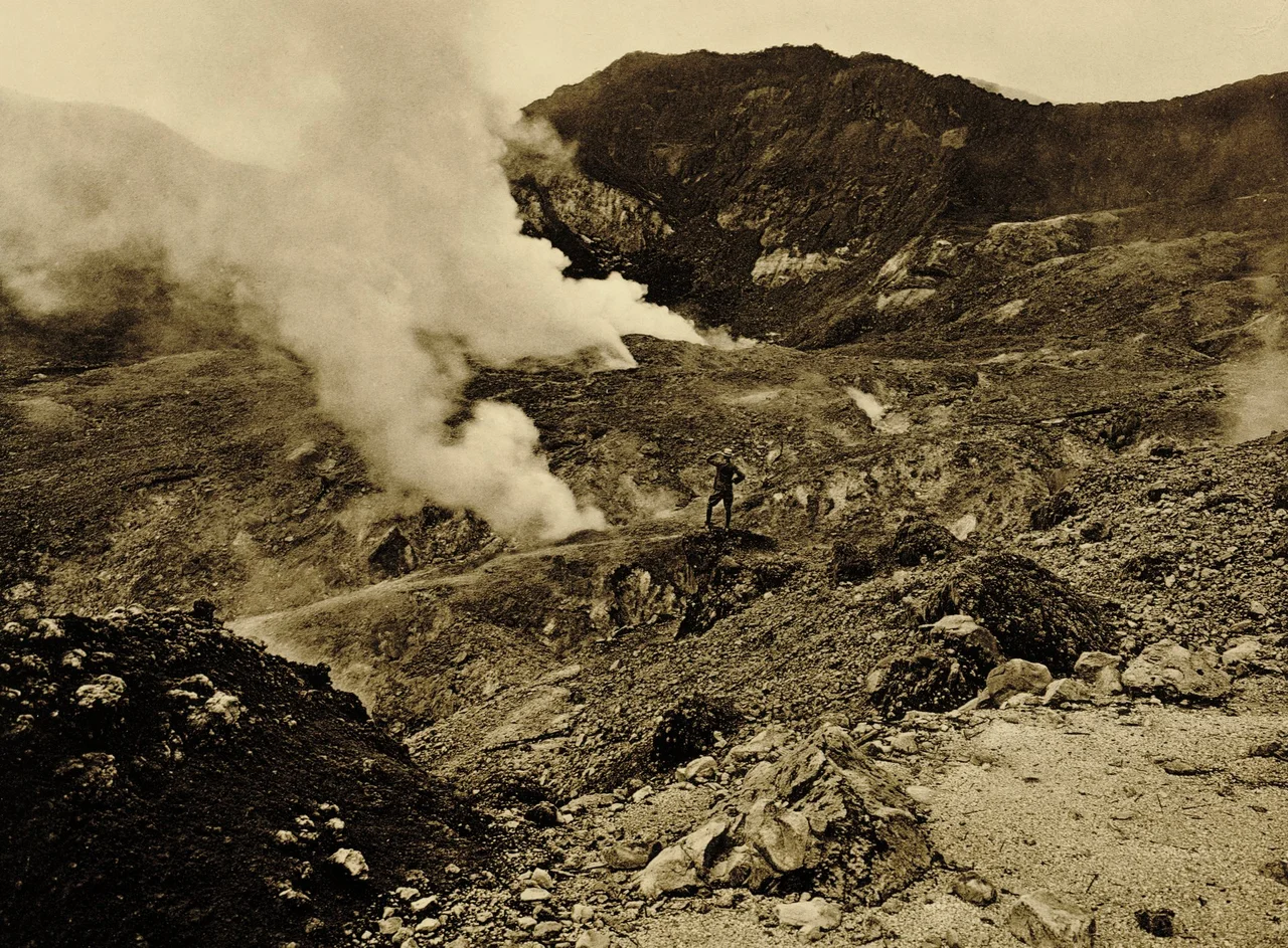
The Scar That Steams
The 1772 collapse carved a massive horseshoe-shaped crater into Papandayan's northeast face, leaving behind a landscape that belongs more to science fiction than to the Sundanese highlands. Four large craters pock the 2,665-metre summit, each containing active fumarole fields -- vents where superheated gas escapes from the volcanic interior. Kawah Manuk and Kawah Papandayan are the most visited, the latter a bubbling yellow cauldron that hisses and spits with enough menace to keep hikers respectful. Solfataras along the inner walls of the horseshoe emit smoke and hot fumes, coating the surrounding rock with crusts of bright yellow sulfur. Tourists walk directly across the crater floor, picking their way between bubbling mud pools, steam vents, and sulfur deposits that stain the ground in vivid, unnatural colors. The air smells like struck matches. The ground is warm underfoot. It is one of the few places on Earth where you can hike into the guts of an active volcano without a permit or a guide.
Two Centuries of Quiet
After the catastrophe of 1772, Papandayan went largely silent for more than two hundred years. Only small phreatic eruptions -- steam-driven blasts caused by groundwater contacting hot rock -- were recorded during that long interval. Then, in November 2002, the mountain erupted explosively, reminding the surrounding communities that quiet does not mean extinct. The volcano settled again, but not for long. In August 2011, Indonesia's volcanology center raised Papandayan's warning status from Level II (Vigilant) to Level III (Alert) after detecting a swarm of long-period seismic events, increasing volcano-tectonic earthquake rates, and carbon dioxide concentrations at the summit crater that measured 100 percent -- an extraordinary reading suggesting that volcanic gases had completely displaced atmospheric air in the soil. Authorities urged everyone, including tourists, to stay at least two kilometres from the yellow craters. By September 2011, the Indonesian National Disaster Management Agency warned that an eruption could affect over 170,000 people across five subdistricts and twenty villages, with as many as 11,500 potentially requiring evacuation.
Living on the Edge
Mount Papandayan sits in Garut Regency, about 15 kilometres southwest of the town of Garut and southeast of the city of Bandung. The region is densely settled -- West Java is one of the most populated provinces on one of the most populated islands on Earth. The volcano's fertile slopes support terraced agriculture, and the cool highland climate attracts weekend visitors from Bandung and beyond. This proximity to large populations is what makes Papandayan's periodic restlessness so consequential. The five subdistricts in the potential impact zone are home to communities whose daily lives unfold within sight of the smoking crater. When the alert level rises, families face an impossible calculation: leave the farms and livelihoods that depend on volcanic soil, or stay and gamble that the mountain will settle back to sleep. The 1772 disaster demonstrated what happens when the gamble fails. Two centuries of relative calm have made it easy to forget, but the seismic swarms of 2011 proved the mountain has not.
A Volcano You Can Walk Through
Despite the hazard warnings, Papandayan remains one of West Java's most accessible active volcanoes. The hike to the crater fields is not technically demanding -- no ropes, no scrambling, no glacier crossings. Visitors park at a trailhead and walk into the volcanic amphitheater, where the full spectacle of Papandayan's geology is laid out at ground level. Mud pools blop and gurgle. Steam jets whistle through cracks in sulfur-stained rock. The famous Kawah Papandayan crater glows yellow at its edges, its contents visibly in motion. It is the rare volcano where the dramatic features are not confined to a distant summit but spread across a walkable plain, making the experience visceral rather than scenic. Mount Puntang, Papandayan's twin peak, rises on the opposite side of the Alun-Alun crater plain, and the view between the two peaks -- across a kilometre-wide flat that only exists because half the original mountain collapsed -- is a constant reminder that the ground you are standing on is the product of catastrophic violence, temporarily at rest.
From the Air
Mount Papandayan is located at approximately 7.33S, 107.72E in Garut Regency, West Java. The twin-peaked summit at 2,665 m (8,743 ft) is visible from cruising altitude, with the distinctive horseshoe-shaped collapse crater opening to the northeast. Active fumarole fields produce visible steam plumes in clear weather. The volcano sits about 15 km southwest of Garut and southeast of Bandung. Nearest major airport is Husein Sastranegara International Airport (WICC) in Bandung. Volcanic activity may produce gas emissions and localized weather effects near the summit.
Nearby Stories
- The Double Life of Cirahong Bridge 6.4 km away
- LAPAN: Indonesia's Space Agency 12 km away
- Gunung Padang: Java's Stairway to the Ancient World 19 km away
- The Drowned City Beneath Bandung 20 km away
- Kraton Kacirebonan 46 km away
- Cipanas Palace 66 km away
- The Island of Flowers and Firing Squads 67 km away
- SIEV X 310 km away