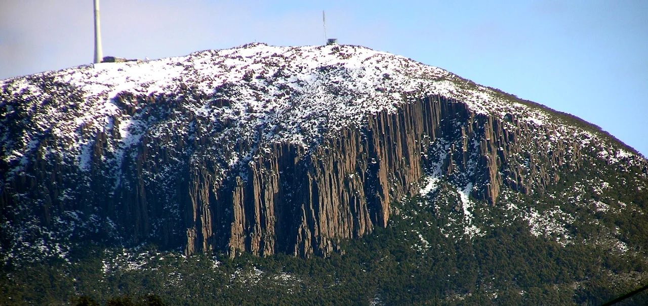

Mount Wellington (Tasmania)
From almost anywhere in Hobart, you look up and there it is: a wall of mountain filling the western sky, snow on its shoulders even in summer, a great organ of grey stone carved into its upper cliffs. The Tasmanian Aboriginal people called it kunanyi, and since 2013 that name has stood officially beside the colonial one as kunanyi / Mount Wellington. The mountain rises 1,271 metres almost directly out of the city, close enough that you can leave a Hobart cafe and stand in alpine cold within the hour, and dramatic enough that it shapes the weather, the light, and the very identity of the town below it.
The Organ Pipes
The mountain's signature is a formation that looks built rather than born. The Organ Pipes are a cliff of dolerite columns, vertical hexagonal pillars towering roughly 120 metres high, that fall away from the summit plateau like the ranks of a cathedral organ. They were forged in deep time. As the supercontinent Gondwana began to tear apart and Australia pulled away from Antarctica, molten rock forced its way between older layers and slowly cooled, contracting into these clean geometric columns. Rock climbers now test themselves on the same buttresses, but from the streets of Hobart the Organ Pipes simply stand there, monumental and strange, the most recognisable rock face in Tasmania.
Naming a Mountain
Few mountains have collected so many names. Abel Tasman likely never saw it in 1642, passing too far out to sea. Later European visitors each tried their hand: John Hayes called it Skiddaw after a peak in England's Lake District, while Matthew Flinders settled on Table Mountain for its flat-topped resemblance to the famous mountain in South Africa. That name stuck until 1832, when the colony renamed it for the Duke of Wellington, the general who had defeated Napoleon at Waterloo. Beneath all of these lay the original: kunanyi, the word the Aboriginal people had used for far longer than any European had been on the island, and the name the mountain carries today.
A Road Cut by Hard Times
The narrow road that switchbacks to the summit is a monument to the Great Depression. In the early 1930s, Tasmanian premier Albert Ogilvie launched it as a relief scheme to put unemployed men to work, and it opened on 23 January 1937. At the time the lower slopes had been heavily logged and stood almost bare, so the new road slashed visibly across the denuded flank, earning the nickname 'Ogilvie's Scar.' The forest has since grown back and hidden it. Halfway up, at around 720 metres, the picnic ground called The Springs marks where a chalet and health spa once stood before the 1967 bushfires erased it, the same fires that destroyed nearly every old excursion hut on the mountain.
Weather at the Edge of the World
The summit keeps a climate that belongs nearer the poles than to a temperate Australian city. Winds have been clocked at sustained speeds above 157 kilometres an hour, with rare gusts reaching 200, fierce enough to stop trees from growing at the top. It is one of the few places in Australia to have never recorded a temperature above 30 degrees, and snow can fall in any month of the year. A single day on the pinnacle can swing from clear sun to rain to sideways snow and back again. The broadcasters who planted transmission towers up here learned the cost of that exposure the hard way; the first steel lattice masts went up in 1960, and ice and gales battered them so badly that the concrete tower standing today, built in the mid-1990s, was engineered specifically to survive what has been called one of the most hostile broadcasting environments anywhere. That same ferocity has shielded the mountain in another way too: in 2022, after the council received more than 16,500 public submissions, an aerial cable car proposal was rejected, and for now the summit keeps its wildness intact.
From the Air
kunanyi / Mount Wellington summits at 1,271 m (4,170 ft) at 42.90 degrees south, 147.23 degrees east, immediately west of Hobart. It is an unmissable terrain feature: a broad, often snow-capped plateau with the vertical Organ Pipes cliffs on its eastern face above the city and the Derwent estuary. The nearest major airport is Hobart International Airport (YMHB), about 22 km east-southeast; Cambridge Aerodrome (YCBG) is also nearby. Exercise serious caution: the summit generates extreme turbulence and downslope winds frequently exceeding 150 km/h, cloud forms and clears rapidly, and icing is possible year-round. Maintain ample clearance above the 1,271 m peak and the broadcast tower atop it; the cleanest views come on rare calm, high-pressure mornings.
Nearby Stories
- Mount Field National Park 6.7 km away
- Bruny Island 19 km away
- Eaglehawk Neck 22 km away
- Maria Island 36 km away
- Lake Pedder 38 km away
- Van Diemen's Land 80 km away
- 2003 Fiordland Earthquake 1547 km away
- Chatham Islands 2954 km away