Mount Wilhelm
A German newspaper correspondent named the peaks for Otto von Bismarck's children. Hugo Zoller stood on the Finisterre Range in 1888 and looked west at the unclimbed spine of what is now Papua New Guinea's Central Cordillera. He christened four of the highest summits Ottoberg, Herbertberg, Marienberg, and Wilhelmberg, after the chancellor and his three eldest. Zoller thought Ottoberg was the tallest. He was wrong. The distant Wilhelmberg was higher - by a wide margin - and the name stuck even after Germany lost its colony, even after the cartographers dropped the Germanic suffix, even after the Kuman people downslope continued calling it what they had always called it: Enduwa Kombuglu.
The Highest Point in Oceania
Mount Wilhelm rises 4,509 meters where three Papua New Guinean provinces meet - Chimbu, Jiwaka, and Madang all converge on the summit ridge. If you define Oceania by political boundaries, this is its roof. By physical geography, Puncak Jaya in Indonesian Papua is higher at 4,884 meters, along with several other peaks on the western half of the island. The ambiguity is why climbers who chase the Seven Summits sometimes bag Wilhelm and sometimes Jaya - different lists count different mountains. What is not ambiguous is the view from the top. On a rare clear dawn, you can see both the Bismarck Sea to the north and the Solomon Sea to the south. Both coasts, from one vantage, in a country whose interior took the outside world until the 1930s to even know existed.
The First Ascent
No European climbed Wilhelm until August 1938. The ascent was led by Leigh Vial, an Australian patrol officer working in the Territory of New Guinea, and crucially by two local men whose names appear in the records as Namba Wan Bare Kuakawa, called Kugl'kane, and Gend, called Mondia Nigle. They were described in the pidgin of the era as Vial's mangi mastas, a term that obscures how much the success of the climb depended on their knowledge of the terrain. The mountain had been sacred to the Kuman for generations before any Westerner saw it from a distance and gave it a chancellor's name. Vial's party reached the summit, but the first people to know the mountain at close range were the people who had always lived in its shadow.
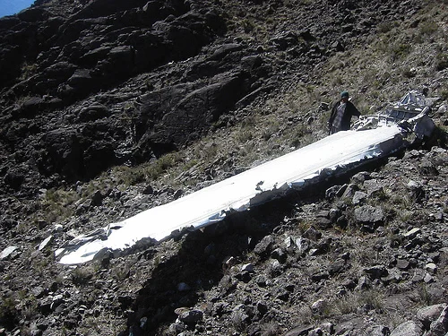
The Bomber in the Lake
On 22 May 1944, an American F-7A - a B-24 Liberator converted for long-range photo reconnaissance - flew too low across the island in pre-dawn darkness. It was named Under Exposed, a pilot's joke that became an epitaph. The plane had launched from Nadzab near Lae on a mission to photograph Padaidori Island in Dutch New Guinea. Around 4 a.m., it struck Wilhelm at roughly 13,000 feet, just above the twin glacial lakes that cradle the summit approach. All ten men aboard were killed. The bodies were eventually recovered, but most of the wreckage fell into the highest of the two lakes - Lake Piunde - where it remains. Climbers passing in thin alpine daylight can still see pieces of the fuselage and a wing that failed to submerge. A mountain that killed a bomber crew from Texas and California, sleeping still at 4,000 meters above sea level on the other side of the world.
The Midnight Climb
Two routes lead to the summit. The common one begins at Keglsugl, a village at the end of the road from Kundiawa. Climbers walk up through cloud forest, then through alpine grassland, then along glacial valleys to the twin lakes of Aunde and Piunde, where two huts offer shelter. One is a former Australian National University research station. The other is a simple A-frame. The summit push starts around midnight. The climb is not technical, but the trail can turn treacherous in wet weather, and the altitude deserves respect. The equator is just four hundred kilometers north, yet temperatures at the summit routinely fall well below freezing. Climbers go at night so they can reach the top at dawn, when clouds have not yet boiled up from the valleys. The ascent and descent together take nine to twenty-four hours. The alternative route from Ambullua in Western Highlands Province is a four-day expedition that few attempt.
The Weight of the Climb
The mountain has claimed climbers over the decades. An Australian Army sergeant, Christopher Donnan, fell down a steep slope in December 1971, and a plaque still marks where he was last seen. An Israeli backpacker in 1995 sprained his ankle, stayed behind while his group continued, and wandered off the track in the dark. Bob Martin, a marketing manager at Air Niugini, suffered a fatal heart attack near the summit in 2005. In 2007 a man from Tari, dressed only in a T-shirt and sports shoes, was killed by a rockfall near the Donnan plaque - he had not been warned about the cold or the scree. These are not the deaths that make mountaineering headlines. They are the quiet accumulation of a mountain that looks accessible and is, until it is not.
From the Air
Mount Wilhelm sits at 5.80 degrees south, 145.03 degrees east, summit elevation 4,509 meters. It is Papua New Guinea's highest peak and a prominent navigational landmark in the Bismarck Range. The terrain rises sharply from the Ramu and Chimbu valleys - expect significant mountain-wave turbulence and afternoon cloud obscuration. Maintain minimum safe altitude; charter flights land at Keglsugl airstrip at the base. Nearest significant airport is Goroka (AYGA) to the southeast, with Port Moresby (AYPY) as the regional hub.
Nearby Stories
- Highlands (Papua New Guinea) 16 km away
- Kuk Swamp 20 km away
- Ramu Nickel Mine 24 km away
- Battle of Madang 38 km away
- Goroka 42 km away
- Kainantu 49 km away
- Territory of New Guinea 50 km away
- 2024 Enga Landslide 123 km away