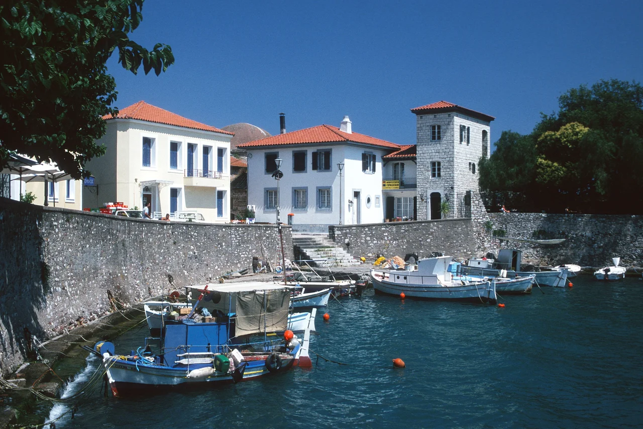

Nafpaktos
The word means "boatyard." Naupaktos — from naus, ship, and peg, to fix — was a place built for vessels, and so it remained for two and a half millennia. Today it goes by Nafpaktos, but the Europeans who fought over it knew it as Lepanto, and that name echoes through the annals of naval warfare. Walk through the narrow gate into the old circular harbor and the sheer accumulated weight of the place lands quietly: Venetian stone, Ottoman memory, and the ghost of a 429 BC battle that kept Athens dominant at sea, all compressed into a few hundred meters of curving waterfront.
A Harbor That History Chose
Naupactus sits just inside the western entrance of the Gulf of Corinth, on a bay where the mountains of Aetolia drop toward the sea. Its strategic logic was obvious from the beginning: whoever held this harbor controlled access to the gulf, and the gulf controlled trade and military movement across half of Greece. The Athenians recognized this after the Greco-Persian Wars and settled Messenian refugees here following the Third Messenian War in 464 BCE. It became their western headquarters during the Peloponnesian War, the base from which admiral Phormio launched the brilliant naval campaign of 429 BC. After Athens fell, the Messenians were expelled and the town passed through Macedonian and Aetolian hands. The Romans came. Pausanias, traveling the coast in the 2nd century AD, found a temple of Poseidon near the sea, temples to Artemis and Asclepius, and a cave sacred to Aphrodite. The historian Hierocles listed it among the significant towns of the 6th century, just before an earthquake in 551 or 552 CE largely destroyed it.
Lepanto: The Name That Stuck to History
The medieval centuries transformed Naupactus into one of the most fought-over possessions in the eastern Mediterranean. Byzantine province, Epirote despotate, Angevin base, Serbian territory, Catalan prize, Albanian despotate, Hospitaller foothold — the town changed hands so often that its very name mutated with each new occupant. The Franks called it Lepant; the Venetians, who bought it from the Spata family in 1407, called it Lepanto and reinforced it heavily because it secured their trade through the gulf. They held it until 1499, when the Ottomans took it during the Second Ottoman-Venetian War. Under the Ottomans, known as Aynabahtı or İnebahtı, it became a naval station. Then, on October 7, 1571, a combined Spanish, Papal, and Venetian fleet destroyed the Ottoman naval force at the mouth of the gulf — the Battle of Lepanto, one of the largest naval engagements in Mediterranean history. The Venetians briefly recaptured the town in 1687 but lost it again in 1699 under the Treaty of Karlowitz. It became part of independent Greece in March 1829, and the ancient name was revived.
The Round Harbor
The Venetians built for permanence. The harbor they engineered at Nafpaktos is circular, enclosed by stone walls and towers, its narrow entrance barely wide enough for two ships to pass — a form designed as much for defense as for shelter. That shape survives almost intact. Cafes and bars ring the inner waterfront now; two of them occupy space within the castle walls themselves. The fortifications climb the hillside in a series of terraced walls, rising more than 200 meters to the upper citadel. From there, the view across the gulf on a clear day reaches the mountains of the Peloponnese on the opposite shore, with the Rio-Antirrio bridge — the world's longest multi-span cable-stayed bridge — spanning the strait at the gulf's mouth to the west. Among the harbor monuments is a statue of Miguel de Cervantes by the Mallorcan artist Jaume Mir: Cervantes was wounded at Lepanto in 1571, losing the use of his left hand, and later called the battle "the most noble and memorable event that past centuries have seen."
The Town Beyond the Walls
Modern Nafpaktos extends along the gulf shore in both directions from the old harbor, residential homes lining the waterfront for roughly three kilometers. The western beach district is called Psani; the eastern, Gribovo. The population numbers around 19,768 according to the 2011 census, making Nafpaktos the second largest town in the regional unit of Aetolia-Acarnania after Agrinio. The mountains press close from the north, and the countryside to the west opens into farmland. The Fethiye Mosque, the largest Ottoman-era religious building in town, stands as a reminder of the four centuries when this was İnebahtı. The bypass road now routes heavy traffic above the town at an elevation of about 150 meters, sparing the narrow medieval streets below. The town is twinned with Cinque Terre in Italy, Dubrovnik in Croatia, and Pontevedra in Spain — all places where the sea and old stone speak the same language.
Where the Gulf Narrows
What draws visitors most is not any single monument but the quality of compression the place achieves — classical, Byzantine, Venetian, Ottoman, and modern Greek coexisting in a very small area between sea and mountain. The nearby village of Skala, a few minutes into the hills, overlooks the whole town. Sandy beaches at Hiliadou and Skaloma, just along the coast, draw summer crowds. The road north leads up through oak-forested mountains toward Lidoriki and eventually Delphi, past the villages of Mountainous Nafpaktia where spring water runs cold even in August. The gulf itself remains the constant — long, blue, enclosed, and shaped by history in ways that few stretches of water anywhere on earth can match.
From the Air
Nafpaktos lies at 38.39°N, 21.83°E on the north shore of the Gulf of Corinth. The circular Venetian harbor is visible from the air as a distinctive enclosed basin; the castle walls climbing the hillside above it are recognizable from altitude. The Rio-Antirrio cable-stayed bridge spanning the strait to the west is an unmistakable landmark. Nearest major airport: LGRX (Araxos), approximately 45 km to the southwest across the gulf. Patras (with road access via the bridge) is 18 km to the southwest. Recommended viewing altitude: 2,000–4,000 feet along the northern shore to see the harbor, fortifications, and gulf panorama clearly.
Nearby Stories
- Desfina 2.7 km away
- Pleuron (Aetolia) 2.8 km away
- Pellene 12 km away
- Achaea 12 km away
- Mendenitsa 13 km away
- Battle of Manolada 13 km away
- Amphilochian Argos 26 km away
- Prousou Monastery 29 km away