Nambija Mine Disaster
It was Mother's Day, May 9, 1993, and the afternoon air in Nambija was thick with rain. Ten thousand people lived on roughly a single square kilometer of Andean valley, their homes built on top of the tunnel entrances to the gold mines that fed them. Many of those homes were made of corrugated tin. Many of the mothers being celebrated that day were inside them. When the mountain at the end of the valley gave way, it buried about eighty houses and an estimated 200 to 250 people sheltering from the storm. Working miners died in the shafts below. The exact count will never be known. Nambija kept no registers of who lived there or who worked the pits, and many of the dead still lie under the slide today.
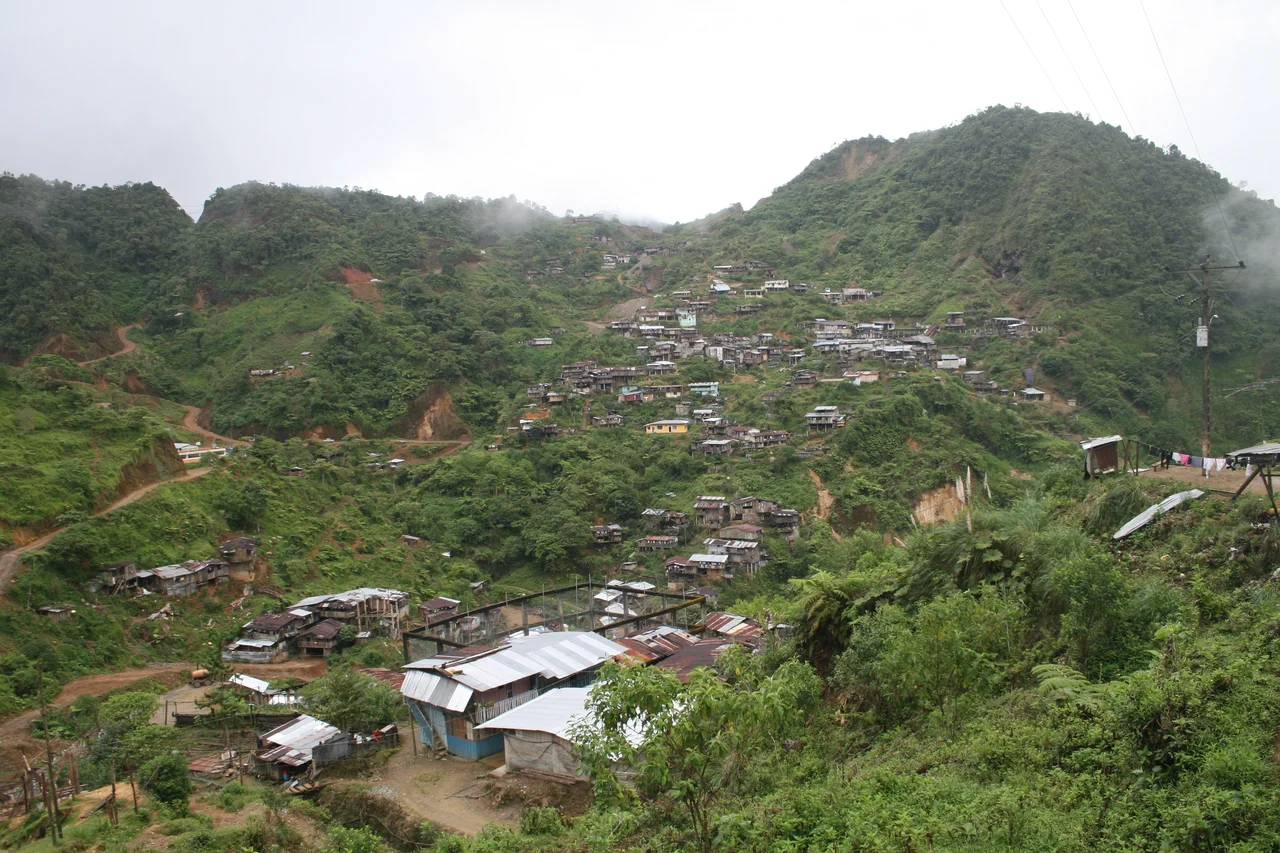
A Town Built on Itself
Nambija sits high in the mountains of Zamora-Chinchipe Province in southeastern Ecuador, about thirty kilometers east of Zamora and close to the Peruvian border. A three-hour drive over a gravel road built only in 1986 gets you there. The town clings to steep slopes at 2,600 meters, a cluster of iron-and-tin structures whose front doors double as mine entrances. Families worked their own claims. Shafts wandered into neighboring shafts. Basic principles of tunnel engineering - support timbers, proper spacing, load-bearing pillars - were routinely ignored because every cubic meter of rock left in place was gold potentially left in the ground. By 1990, experts warned that the mountains around Nambija had been hollowed out so thoroughly that a major landslide was no longer a question of if but when. The constant vibration from a huge rock-crushing plant in the center of town made the warning sharper.
The Day the Mountain Fell
The days before May 9 had brought torrential rain. Soil that was already loose from years of undercutting turned to slurry. Sometime that afternoon, a large section of the mountain above the mines and the upper town simply let go. Eighty homes vanished. The people inside them, along with miners deeper in the shafts, were buried so quickly and so completely that rescue teams - when they arrived, days late, over that rough gravel road - could do little more than survey the scale of what had happened. Early reports put the death toll at around 80. Later estimates climbed to 400. The figure most often cited is 300. Any number is an approximation, because Nambija's population was fluid and informal. People came to try their luck and sometimes stayed under their adopted names. Wives and children arrived without paperwork. The dead, in many cases, were not missed by any official record.
The People Under the Mountain
It is easy to let Nambija disappear into phrases like "informal miners" and "one of the worst mining disasters ever." The people who died were not statistics of risk acceptance. They were parents and children and siblings who had come to these mountains because there was gold in them and there were no other jobs in their home villages that paid in anything but promises. Some had walked in as teenagers and grown old underground. Many were Ecuadorian. Some were Peruvian. They bought rice and meat from the town's few shops, argued over shaft boundaries, held weddings and funerals, sent money home when they could. On Mother's Day 1993, they were doing what Ecuadorian families do on Mother's Day - gathering inside, eating together, waiting out the rain. The slide did not distinguish among them.
Still Mining, Still Grieving
The scar of the 1993 slide is still visible on the mountainside, and it is now treated as a mass grave - most of the bodies were never recovered. In the parts of the settlement that were not buried, work resumed within days. This was not callousness. It was necessity. There was nowhere else to go and no other way to earn. Nambija continues as a mining town today, smaller than it was, still reaching its tunnels into rock that experts thirty years ago said was already too compromised. The disaster is virtually unknown outside Ecuador, a combination of the site's remoteness, the informality of the casualties, and the way that deaths among the world's poorest workers tend to be counted. It deserves to be remembered better - not as a cautionary statistic, but as the day that roughly 300 people, most of them mothers and the children of mothers, died under a mountain that everyone knew was going to fall.
From the Air
Coordinates: 4.07°S, 78.79°W. In Zamora-Chinchipe Province, southeastern Ecuador, about 30 km east of Zamora near the Peruvian border. Terrain is rugged sub-Andean with deep valleys at ~2,600 m elevation. Nearest airport is Ciudad de Catamayo (SETM/LOH) serving Loja, about 100 km west. Flying over requires VFR conditions - valley fog and afternoon convective buildups are common. The landslide scar on the valley's eastern wall remains visible from altitude.
Nearby Stories
- Zaruma 26 km away
- Loja Province 33 km away
- Santa Ana (La Florida) 36 km away
- Ayabaca province 40 km away
- Saraguro People 44 km away
- Cueva de los Tayos 93 km away
- Borja, Peru 95 km away
- 2021 Northern Peru Earthquake 177 km away