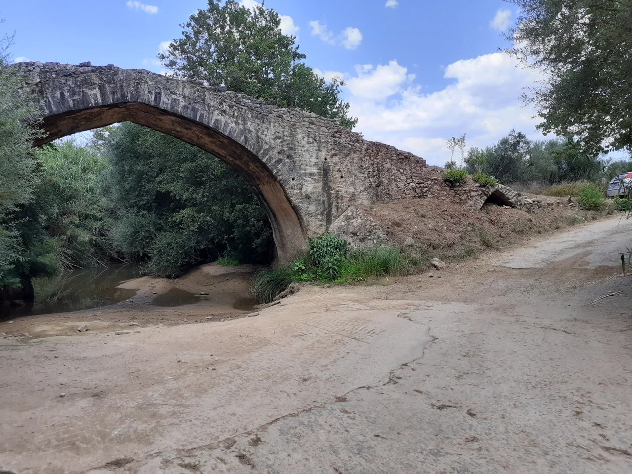

Ntempriz Bridge
Carved limestone blocks, stacked without mortar by medieval builders, have held their arch over the Velikas River canyon for centuries — through Frankish lords, Ottoman campaigns, Greek independence, and two world wars. The Ntempriz Bridge, also called Strefeiko Gefyri, is barely wide enough for a carriage. That was the point. It was built to carry people, goods, and soldiers between Pylos and Messini across a canyon that the river had spent millennia cutting through the rock, and it still stands roughly 1 kilometer west of the village of Strefi, doing what it was built to do.
A Bridge in the Time of the Franks
The Frankish period in Greece — the Frankokratia, the era when Western European crusaders and their descendants held dominion over much of the Peloponnese following the Fourth Crusade of 1204 — left behind a landscape dotted with castles, roads, and infrastructure. The Ntempriz Bridge belongs to this world. Most sources agree it was built during the Frankokratia, though no precise date has been established from the surviving evidence. That uncertainty is itself meaningful: the bridge was built as a practical structure, not a monument, and the documents that might have dated it precisely were never kept or have not survived. What remains is the stonework itself, which researchers consider among the oldest bridge construction in Messenia.
Stone and Water
The design is elegant in its economy. The bridge spans the canyon with two arches: a large main arch with a slight obtuse curve, sized to carry the bulk of the Velikas River's flow, and a smaller secondary triangular arch on one side to handle overflow. Both are built of limestone, the abundant local stone that gives the Messenian uplands their pale, sun-baked character. The roadway is just wide enough for a loaded cart — not a highway, not a grand viaduct, but a working crossing built by people who understood exactly what they needed and built precisely that. At the bridge's exit, historical records indicate that a watermill once stood, using the same river current the bridge was designed to cross. The mill is gone; the arches remain.
Castle on the Hill
A few hundred meters southeast of the bridge, on a prominent hill, stand the ruins of Ntempriz Castle. The castle and the bridge almost certainly belong to the same medieval settlement, with the castle's inhabitants among the primary users of the crossing. This pairing — fortified high ground commanding a river crossing — was standard practice in medieval military geography. Whoever held the castle held the bridge, and whoever held the bridge controlled movement through the canyon below. The castle's ruins are now little studied and sparsely documented, leaving the bridge as the more visible survivor of what was once a complete medieval fortified landscape at this bend of the Velikas.
Crossing Time
The Velikas River runs through limestone terrain that has shaped the human geography of Messenia for millennia. In summer, water levels drop sharply, and the canyon walls stand exposed — a quieter version of the fast-running torrent that made a bridge necessary in the first place. Standing on the Ntempriz Bridge now, with the old stone under your feet and the canyon dropping away on both sides, it is easy to lose the distinction between medieval and modern. The arch above the river doesn't announce itself. It simply works, as it has worked for centuries, connecting one bank to another across a gap that the river opened and the builders closed.
From the Air
The Ntempriz Bridge sits at approximately 37.055°N, 21.875°E, in the canyon of the Velikas River roughly 1 km west of Strefi village in Messenia. From the air at 1,500–3,000 feet, the canyon is visible as a green incision in the pale limestone uplands southwest of Kalamata. The nearest airport is Kalamata International (LGKL), approximately 20 km to the northeast. The bridge itself is small and best appreciated from low altitude; look for the canyon fold in the terrain west of Strefi, where the river emerges from the hills toward the coastal plain.
Nearby Stories
- Las (Greece) 1.3 km away
- Karyes 3 km away
- Psari, Messenia 10 km away
- Diocese of Amyclae 11 km away
- 2023 Messenia Migrant Boat Disaster 20 km away
- Kalamakia Cave Site 36 km away
- Agios Andreas, Katakolo 46 km away
- El-Kouf National Park 445 km away