_Topography.png)
Numfor: The Island That Spanish Galleons Glimpsed and War Transformed
On June 24, 1528, the Spanish navigator Alvaro de Saavedra was trying to sail back to New Spain from Tidore when he spotted an oval-shaped island rimmed with coral reefs. He did not stop. Seventeen years later, another Spanish captain, Inigo Ortiz de Retes, sighted the same island from the deck of the galleon San Juan while attempting the same impossible eastward crossing of the Pacific. He did not stop either. Numfor had a way of being seen but not touched, noticed but not claimed -- until the 20th century, when its flat terrain and strategic position made it irresistible to military planners willing to pay any cost to build runways on it.
Coral Fortress in Cenderawasih Bay
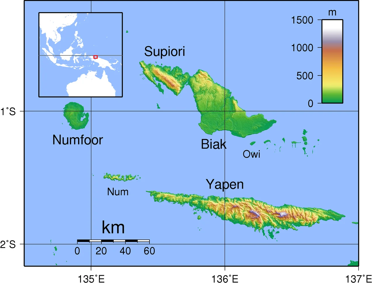
Numfor sits on the northern side of Cenderawasih Bay, the vast inlet formerly known as Geelvink Bay, off the coast of New Guinea. Roughly oval, it covers 335 square kilometers of limestone, coral terraces, and tropical rainforest. An almost continuous ring of coral reef encircles the island, broken only at a few points along the southeastern coast where low, steep cliffs drop to the water. The interior is dense forest -- part of the Biak-Numfoor rain forest ecoregion, a pocket of biodiversity that evolved in relative isolation. One of the Schouten Islands, Numfor falls within the Biak Numfor Regency of Papua province. As of the 2010 census, roughly 9,300 people lived here across five districts. Most communities cluster along the coast, where fishing and small-scale agriculture sustain a way of life that has changed slowly over centuries.
Sultans and Seafarers
Before Europeans arrived, Numfor existed within the sphere of the Tidore Sultanate, one of the powerful spice kingdoms of the Maluku Islands. Seafarers from the region paid regular tribute to the sultan, maintaining connections across hundreds of miles of open ocean in outrigger canoes and small trading vessels. The relationship was not unusual for the region -- Tidore's influence extended across a vast maritime network reaching deep into New Guinea's coastal communities. What made Numfor noteworthy was its position: close enough to the major sea lanes to be worth claiming, remote enough that no power ever invested heavily in controlling it. The Spanish sightings of 1528 and 1545 reflected European ambitions to master the Pacific passage from Asia to the Americas, a route that would not become practical for centuries. Numfor was a landmark on a journey no one could yet complete.
Occupation and Forced Labor
Japanese forces occupied Numfor in December 1943. The indigenous population of about 5,000 people, most living subsistence lives in coastal villages, suddenly found their island transformed into a military construction site. The Japanese brought more than 4,000 laborers to build three airfields: Kornasoren (Yebrurro) toward the north, Kameri on the northwest edge, and Namber on the west coast. Six hundred were Formosan auxiliary workers; the rest were Indonesian civilians, many of them Javanese men, women, and children taken from cities like Surabaya. They built runways and roads by hand with almost no food, shelter, or medical care. Those who tried to steal Japanese supplies were executed. Others died of starvation and disease. By the time the fighting ended in August 1944, only 403 of the original 3,000 Javanese laborers remained alive, according to the U.S. Army official history. Their suffering is one of the war's lesser-known atrocities.
The Battle That Ended Quickly
Allied forces landed on Numfor on July 2, 1944, targeting the airfields the Japanese had built at such cost. After days of bombardment that dropped 800 tons of bombs on the island, the initial assault near Kameri Airfield met almost no resistance. American newspapers reported near-zero casualties reaching the shore despite the coral reef barrier. Paratroopers from the 503rd Parachute Infantry Regiment dropped onto the island the following day, though their greatest enemy proved to be the drop itself -- low-altitude jumps onto hard ground produced dozens of broken legs. Yebrurro Airfield fell by July 4. Namber was taken without resistance on July 6. The island was declared secure on July 7, though Japanese soldiers continued guerrilla actions until August 31. Allied losses totaled 66 killed or missing and 343 wounded. The captured airfields quickly became launch points for B-24 Liberator raids against Japanese oil refineries at Balikpapan, Borneo.
An Island Returns to Quiet
After the war, Numfor settled back into the rhythms that had defined it for centuries. The airfields that cost so many lives gradually deteriorated in the tropical climate, reclaimed by vegetation and weather. The coral reefs that had complicated amphibious landings continued their slow growth around the island's perimeter. The rain forest that covers most of the interior -- part of a globally significant ecoregion -- kept generating the humidity and rainfall that make this corner of Papua so lush and so difficult to build on permanently. Today's Numfor is a quiet place. Fishing boats work the reef edges. Communities in the five districts maintain traditions that predate every flag that was ever raised or lowered over the island. The Spanish galleons are long gone. The Japanese garrisons are gone. The B-24s are gone. The coral keeps growing, and the forest keeps closing in on whatever humans leave behind.
From the Air
Numfor island sits at approximately -1.04 lat, 134.89 lng in Cenderawasih Bay, Papua province, Indonesia. The island is distinctly oval-shaped, about 335 square kilometers, and clearly visible from altitude as a green landmass surrounded by the lighter turquoise of coral reefs against the deep blue of the bay. It lies between Biak island to the east and the Bird's Head Peninsula (Doberai Peninsula) of mainland New Guinea to the west. The three WWII airfield locations -- Kornasoren (north), Kameri (northwest), and Namber (west coast) -- may be partially visible as lighter patches in the canopy. The nearest significant airport is Frans Kaisiepo Airport (ICAO: WABB) on Biak. Expect tropical conditions year-round with frequent cloud buildup and rain. Recommended viewing altitude: 8,000-15,000 ft for the full island shape and reef system.
Nearby Stories
- Manokwari: Where Empires Came and Went 26 km away
- Biak Archipelago 63 km away
- Owi Airfield 96 km away
- Cenderawasih Bay 152 km away
- Where the Mangroves Stand Thirty Meters Tall 157 km away
- Mapia Atoll 185 km away
- Spring Rain on Dark Water 185 km away
- Yoshino-Kumano National Park: Cherry Blossoms, Sacred Water, and Ancient Stone 3837 km away