Port of Calais
Stand on the harbor wall at Calais on any weekday morning and the rhythm of the place sorts itself out within minutes. A blue-and-white DFDS ferry slides out past the breakwater bound for Dover. A P&O vessel inches into the berth it just vacated, drops its bow ramp, and disgorges three lanes of lorries and a procession of British family cars. Ship-to-shore cranes lift containers from a cargo deck farther up the channel. Somewhere a passenger announcement plays in two languages. The whole machine repeats itself, on average, every thirty minutes. The Port of Calais is the fourth largest in France by tonnage but the first by people - more than eleven million of them in 2018, more than ten million most years - and it has been the principal gateway between France and Britain for so long that the geography itself has been reshaped to make the rhythm work.
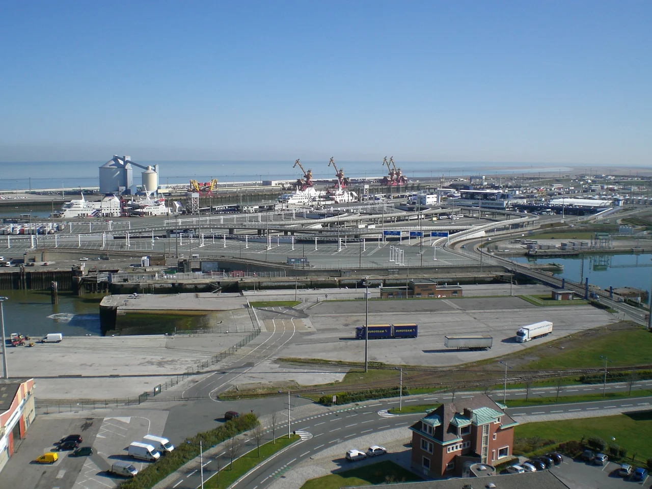
Avant Port, Arriere Port
Approach the harbor from the sea and you come in down a dredged channel running west, then turn north-east past the harbor entrance into the Avant Port - the outer harbor where everything sorts itself before going anywhere further. From here the water splits. One arm runs east-north-east into the Bassin President Henri-Ravisse, which holds the main ferry berths on its southern shore and a roll-on roll-off dock on the northern one. The berths are sized for ferries up to 215 meters long. Past them lie the cargo docks, where four ship-to-shore cranes hoist containers from the holds of freighters. The other arm runs south-east down the Canal de Calais, past the ferry terminal, and turns south into the Arriere Port - the back harbor, where behind a sluice gate and a moveable bridge sits the Bassin de l'Ouest, used by yachts and pleasure boats. Further on are locks, then the Bassin Carnot for secondary cargo, then another set of locks branching into the wider French canal network. Every basin has a function. Nothing is decorative.
The Border Before the Border
Travelers boarding ferries to Dover do their passport checks in Calais, not in Dover. Under the Le Touquet Treaty of 2003 - a treaty whose name is now shorthand for the arrangement - the UK Border Force operates a permanent presence inside the port's immigration control zone, with full powers to refuse entry, to arrest, and to detain. French Border Police and French Customs sit in adjacent booths handling the exit side. The Schengen Area ends not at the water's edge but at the booth window. The arrangement saves time on arrival in England and shifts the practical burden of immigration enforcement to French soil. It is also, alongside the parallel arrangement at the Eurotunnel terminal four miles inland, the legal architecture that made the Calais Jungle a Calais problem rather than a Dover one - the reason refugees gathered here in the dunes and woods, just outside the controlled zone, hoping to find a way past it.
The Hovercraft That Were
On 1 April 1969 the Calais Chamber of Commerce opened a hoverport on the eastern side of the harbor, built to service the SR.N4 hovercraft of Hoverlloyd, running across to Ramsgate in Kent. For thirty-one years the great rectangular machines roared up onto concrete aprons, their four turbofans whining down as the cushion deflated, while passengers walked off through the spray. They were faster than the ferries - a Channel crossing of around forty minutes, compared to ninety by ship - but vastly more expensive to operate, and they did not survive the combination of the Channel Tunnel's opening in 1994 and rising fuel costs. Hoverspeed, the last operator, ceased hovercraft operations on 1 October 2000. The Dover-Calais Hoverspeed service was the last commercial hovercraft passenger route in the world. The Calais hoverport was finally demolished in 2016 and absorbed into the broader workings of the port. A few low concrete platforms are all that remains.
Every Thirty Minutes
Cargo traffic through Calais tripled in the two decades to 2007: over 41.5 million tonnes of freight, 1.4 million trucks and trailers, 2.249 million cars, 11.52 million passengers, 4,700 ship movements per year. The Dover-Calais ferry route alone carried 9,168,000 passengers in 2018. Three companies run regular services: DFDS Seaways, P&O Ferries, and the now-defunct SeaFrance which entered liquidation in 2012. Behind the port lies a road network designed entirely around it - the A16 autoroute curving north toward Dunkerque, the A26 running south-east toward Reims, the A1 reaching Paris in around three hours by truck. Train services through Gare de Calais-Ville reach Lille, Boulogne, Dunkerque, and onward via TER Hauts-de-France. TGVs from Calais-Frethun, the next station up the line, run to Lille-Europe and Paris Gare du Nord, with Eurostars stopping there as well on the way to London. The Port of Calais was the first cable-ship port in Europe. It was where the transatlantic telegraph cables came ashore on the French side, where the wires that wired the world together began. The traffic has changed shape. The function has not. People and goods and information still come through here on the way somewhere else, every thirty minutes, all day.
From the Air
Located at 50.97 degrees North, 1.86 degrees East, immediately north of central Calais. The harbor entrance opens into the Strait of Dover, with the main ferry basin (Bassin President Henri-Ravisse) running east-north-east from the outer harbor. Cruise 1,500 to 4,000 feet for clear sight of vessel movements and the layout of the basins. Nearest airfields: Calais-Dunkerque (LFAC) 5 km east-north-east, Saint-Inglevert (LFIS) 14 km south-west. Heavy maritime traffic offshore - the Strait of Dover is among the busiest shipping lanes in the world, with vessel separation schemes in operation. Cross-Channel ferries depart on a roughly thirty-minute cycle throughout the day.
Nearby Stories
- Dover Patrol Monument 1.1 km away
- 2021 English Channel Disaster 5.9 km away
- Westhoek 9.8 km away
- Le Paradis Massacre 14 km away
- Yser 18 km away
- Admiralty Pier Turret 26 km away
- Courrieres Mine Disaster 72 km away
- Cléon 148 km away