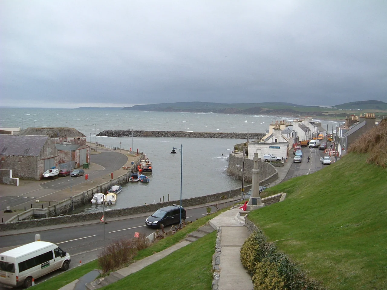

Port William, Dumfries and Galloway
In 1770, a Galloway baronet decided the village beside his house was wrong, and he replaced it. Sir William Maxwell, 5th Baronet of Monreith, swept away the ancient settlement of Killantrae and over the next five years built an entirely new fishing village in its place - new streets, new houses, a new harbour, and a new name borrowed from himself: Port William. The corn mill on the side of the Killantrae burn, still standing, is among the few buildings that survived the rebuild. Two and a half centuries later, the planned village he laid out on the eastern shore of Luce Bay still functions, still fishes, and still bears the name of the man who erased what came before it.
The Church on the Beach
The original settlement was called Killantrae - cill an traigh in Gaelic, meaning the Church on the Beach - and it was probably founded not long after St Ninian arrived at nearby Whithorn at the end of the 4th century. For thirteen centuries Killantrae lived on the shore of Luce Bay as a small Christian community, fishing the bay and farming the inland fields, before the Maxwell estate decided in 1770 that planned villages were the future and that the old layout had to go. The new village kept the corn mill. It kept the burn. It did not keep the name. Killantrae now exists only on old maps and in the memory of place-name scholars, while Port William - laid out on a grid, harbour-centred, named for its baronet developer - is what you find on the modern road sign.
A Harbour Built for the Tenant Farmers
The harbour was Sir William's most useful contribution. He built it for his tenant farmers - so they could ship grain, lime, kelp, and coal in and out without the long overland haul to Wigtown or Stranraer - and it was one of the first harbours in western Galloway. It worked. Extended in 1790 and again in 1848, the harbour kept its commercial importance until the end of the First World War, by which time railways and motorised trade had pulled most of the coastal cargo trade onto land. A breakwater was added on the western side in the 1980s to protect against storms that the original engineers had not had the means to design for. Today a bronze statue of a fisherman, originally cast in concrete and later recast in bronze with help from the millennium lottery fund, overlooks the harbour. A plaque carries the first verse of W. H. Davies' poem 'Leisure': 'What is this life if, full of care, we have no time to stand and stare?'
The Otter Man of Elrig
Just inland from Port William lies Elrig, a clachan of a few houses sitting in the parish. In 1914 a boy was born at The House of Elrig who would grow up to become one of the most read British nature writers of the 20th century. Gavin Maxwell - FRSL, FIAL, FRGS - was educated, eccentric, and devoted to wild animals. His book Ring of Bright Water, published in 1960 and centred on the otters he kept at his house on the Scottish west coast, became a global bestseller and a film. He died in 1969. The Maxwell family still has connections to the area, and the ancient family estate and grounds are in nearby Monreith. A memorial sculpture of an otter, made by Penny Wheatley, overlooks Luce Bay in his memory - a small acknowledgement that the boy from Elrig grew up to teach a generation of readers how to look at wild things.
When the RNLI Said No
In the late 1970s, Luce Bay had a problem. Vessels kept getting into trouble in the unpredictable waters between the Rhins and the Machars, and the village asked the Royal National Lifeboat Institution to station a lifeboat at Port William. The RNLI considered the request and declined. The villagers' response was to do it themselves. They formed the Port William Inshore Rescue Service Action Committee - PIRSAC - and raised funds to buy and staff an inshore rescue boat. The boat was launched in 1979, and it still operates today, covering Luce Bay, Wigtown Bay, and the inshore waters between southwest Scotland and the Isle of Man. The village also formed one of the first Community First Response Teams in Scotland - civilian volunteers trained to respond to medical emergencies in advance of paramedics - and has helped set up similar teams across the region. The whole arrangement is what self-reliance looks like in a place that lies a long way from any hospital.
Looking Three Ways at Once
Stand on Port William's shore on a clear day and the view unfolds in three directions. South across Luce Bay is the Rhins of Galloway, with the Mull at its tip - Scotland's southernmost point. Beyond the Mull, only 20 miles further across the Irish Sea, the long blue mass of the Isle of Man. North-west, on a really good day, the Antrim coast of Northern Ireland appears as a thin grey line. Port William itself is small - a population of about 460, a post office, a takeaway, a restaurant, a charity shop, a couple of small stores. For groceries you go to Whithorn or further to Newton Stewart. Monreith House, the Maxwell family seat, sits a mile east as a Category A listed Georgian mansion. The smugglers of the 17th and 18th centuries who used these coves are long gone, but their reputation is still on the local plaques - and the harbour they helped make notorious is still there, sheltered, north-facing, doing its quiet work.
From the Air
Located at 54.76°N, 4.58°W on the eastern shore of Luce Bay in the Machars peninsula, Dumfries and Galloway. Port William sits between Elrig and Mochrum to the north and Monreith to the south, looking across Luce Bay to the Rhins of Galloway. Visible from cruising altitude in clear weather. The MoD Luce Bay weapons range lies immediately offshore to the west and is normally active - check NOTAMs carefully. Nearest airports: West Freugh (EGOY) is on the Rhins across the bay; Prestwick (EGPK) lies further north on the Ayrshire coast. Cruise around 2,500-4,500 ft along the Machars coast for the best view of the harbour, Monreith House to the east, the Mull of Galloway southwest, the Isle of Man south, and on the clearest days, the Antrim coast of Northern Ireland west.
Nearby Stories
- Kenmure Castle 7.1 km away
- SM UB-85 7.7 km away
- Plunton Castle 8.9 km away
- Portavogie 12 km away
- Battle of Glen Trool 18 km away
- International Institute of Space Commerce 19 km away
- St Bees Lifeboat Station 40 km away
- Dunaverty Castle 40 km away