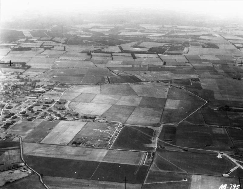

RAF Feltwell
The same patch of Norfolk farmland that once held Royal Air Force bombers and, later, Thor nuclear missiles is now used to track satellites in orbit. RAF Feltwell, in the flat fens about ten miles west of Thetford, has spent eight decades adapting to whichever piece of geopolitical hardware needed a home. It was built in the late 1930s during the expansion that braced Britain for the coming war. After 1945 it hosted Thor intermediate-range nuclear missiles. From 1989 it carried out passive space surveillance for the United States Air Force. In November 2024, small drones appeared overhead at night - unidentified, persistent, and serious enough that F-15E Strike Eagles were scrambled from neighbouring RAF Lakenheath and RAF Regiment personnel were deployed with anti-drone systems to defend the base.
Bomber Station
Feltwell opened during the late-1930s RAF expansion, laid out to the standard pattern that produced its near-identical neighbours at RAF Marham, RAF Watton, and RAF West Raynham. During the Second World War it was home to a succession of heavy bomber squadrons - first Wellingtons of Bomber Command, later other types as the war evolved. Norfolk and its bomber stations were close enough to the Continent to put the German Ruhr within reach, and the flat agricultural landscape was perfectly suited to long parallel runways and the dispersed hardstandings the bombers required. The crews who flew from here had some of the heaviest casualty rates in any branch of the British armed forces.
Thor in the Fields
Between 1958 and 1963, Feltwell hosted PGM-17 Thor intermediate-range ballistic missiles - sixty feet of liquid-fuelled rocket with a thermonuclear warhead, jointly operated by the RAF and the US Air Force under a dual-key arrangement that gave both governments a veto over launch. Twenty IRBM sites scattered across eastern England carried 60 Thors at the peak of the deployment, aimed at targets in the Warsaw Pact and the western Soviet Union. The missiles were withdrawn in 1963, victims of the rapid pace of Cold War technology - submarine-launched Polaris had made them obsolete almost as soon as they were emplaced. From September 1963 the RAF's Officer Cadet Training Unit moved in from RAF Jurby on the Isle of Man, turning the missile pads back into a training establishment.
Eyes on Orbit
From 1989 the base hosted the US Air Force's 5th Space Surveillance Squadron, part of the Passive Space Surveillance Network. The squadron's job was to track the physical location of emitting satellites in orbit. That data, combined with information from other systems, was used to adjust the orbits of various satellites and crewed vessels - including the Space Shuttle and the International Space Station - to reduce the risk of on-orbit collisions. The 5 SPSS reported through the 21st Operations Group and 21st Space Wing at Peterson AFB in Colorado, then to the 14th Air Force at Vandenberg AFB in California, then to Air Force Space Command headquarters back at Peterson. The chain was long. The mission was specific. A patch of Norfolk fenland had become a node in the architecture of American space awareness.
Space Force
In September 2020 the 18th Intelligence Squadron, which had administered Detachment 4 at Feltwell, was inactivated and immediately reactivated as the United States Space Force's 73rd Intelligence, Surveillance and Reconnaissance Squadron, assigned to Space Delta 7 and still hosted at Feltwell. The base now sits under the administrative control of the 48th Fighter Wing, the F-15-equipped USAF wing based at nearby RAF Lakenheath, with Feltwell serving primarily as a support site for regional Army and Air Force Exchange Service logistics and as housing for the US personnel who fly and maintain those Lakenheath fighters. The runways are gone. The mission has migrated upward.
The Drones of November 2024
Between 20 and 22 November 2024, small unmanned aerial systems appeared in the vicinity of, and over, RAF Feltwell - part of a wider series of drone incursions over American air bases in the United Kingdom that month, also affecting RAF Lakenheath and RAF Mildenhall. The drones varied in size and configuration; their numbers fluctuated. F-15E Strike Eagles based at Lakenheath were reportedly scrambled in response, and the incursions affected local flight operations. RAF Regiment personnel deployed to the bases with the ORCUS counter-unmanned-aerial-systems suite after a second sighting on the night of 25 November. The episode passed without official attribution. It was a reminder that the small, cheap, anonymous drone is now part of the security calculus of any military base - including ones, like Feltwell, that spend their days watching satellites high above.
From the Air
Coordinates 52.48 N, 0.52 E, in the Norfolk fens approximately 10 miles west of Thetford, in the borough of King's Lynn and West Norfolk. From the air, the original 1930s pentagon-shaped airfield perimeter and triangular runway layout are still partly visible, though the runways themselves have been largely repurposed for housing and support functions. RAF Lakenheath (EGUL) lies 5 nautical miles to the south-east, RAF Mildenhall (EGUN) 6 nm south, and RAF Marham (EGYM) about 15 nm north. London Stansted (EGSS) is 45 nm south-west. Active military airspace - this is restricted area for civilian traffic; check NOTAMs before any approach.
Nearby Stories
- Bourn Windmill 5.6 km away
- Needham Market 6.1 km away
- Castle Rising Castle 7.6 km away
- Norfolk Tank Museum 10 km away
- Spalding War Memorial 11 km away
- Clare, Suffolk 14 km away
- RAF Wyton 15 km away
- RAF Matlaske 17 km away