The Eye of Krakatoa
Geologists call it "the Eye of Krakatoa." Halfway up the sheer northern cliff of Rakata, a lenticular bulge of solidified magma six meters across stares out from the rock face like the pupil of some buried titan. It sits at the terminus of the largest of more than 25 volcanic dikes exposed in cross-section along the cliff -- a geological record laid bare with the precision of a surgeon's cut. On the morning of August 27, 1883, the northern half of this mountain simply ceased to exist, torn away in an eruption that collapsed two-thirds of Krakatoa island into the sea. What remained was this: the southern half of Rakata, its interior exposed to the sky, standing 813 meters above the Sunda Strait like a broken tooth in an empty jaw.
The Peak That Survived
Before the catastrophe, Rakata was known simply as "the Peak" -- the largest and southernmost of three volcanic cones that formed the island of Krakatoa. Danan occupied the center at 450 meters. Perboewatan, the lowest at 120 meters, sat to the north. All three shared a common magma source beneath the strait, but they were separate vents of the same restless system. When eruptions began in May 1883, Perboewatan went first. Danan followed in June. Rakata, ironically, played the smallest role in its own destruction. Dutch geologist Rogier Verbeek later concluded that unlike the other two cones, Rakata was not directly above the magma chamber. It connected only by a fissure along the caldera's cleavage line -- close enough to be ripped in half, far enough to avoid total annihilation. Captain Ferzaneer, who visited on August 11 and mapped the island's eruptive activity, found no active vents on Rakata or its slopes. The mountain watched the others burn.
A Cliff Like No Other
The vertical face that the 1883 eruption left behind is one of the most striking geological exposures on Earth. Rakata's entire eruptive history is written in that wall of rock: layer upon layer of lava flows, ash deposits, and intrusive dikes, each one a chapter in a story stretching back thousands of years. The largest dike runs from sea level to 320 meters, a stripe of harder rock cutting through softer material, terminating in the convex formation that earned its arresting nickname. Verbeek noted in post-eruption surveys that the cleavage line ran roughly through Rakata's old summit. The remnant actually measured slightly taller afterward -- 830 meters compared to the pre-eruption 820 -- though this may reflect the inaccuracy of earlier surveys rather than any volcanic growth. Examining the cliff face from the air reveals two distinct arcs of collapse. The first is the 1883 caldera wall itself. The second, subtler arc appears to be the work of later landslides, as unstable material continued to peel away from the exposed face in the years and decades that followed.
Genesis from Ash
When scientists reached Rakata in May 1884, nine months after the eruption, they found the island scoured nearly to sterility. The blast had buried everything under meters of hot ash and pumice. One spider, sheltering in a crevice on the southern face, was the sole animal survivor anyone could locate. But life was already stirring. By October 1884, grass shoots had broken through the crust. Seeds arrived on ocean currents, spores drifted in on the wind, and birds carried seeds in their droppings. Within 25 years, the first resident land birds had established themselves -- generalist species, open-country survivors comfortable in a landscape still far from forest. Within a few decades, over 200 species of vascular plants had colonized the Krakatoa islands, and Rakata's eastern slopes were thickening toward something resembling tropical forest. The recovery became one of the founding case studies in island biogeography, the field that asks how isolated ecosystems assemble themselves from scratch.
The Laboratory That Keeps Resetting
What makes Rakata uniquely valuable to science is the cruelty of its neighbor. Anak Krakatau, the volcanic island that began rising from the caldera in 1927, erupts frequently enough to disturb the recovering ecosystem on nearby Rakata -- ash falls, acid rain, shockwaves through the air and water. Each eruption partially resets the ecological clock. Scientists have been able to study not just how life colonizes a barren island, but how it responds to repeated disruption -- a compressed version of the cycles that shape island ecosystems over geological time. Bats recolonized Rakata between 50 and 70 years after 1883. Forest-dependent bird species replaced the early open-country colonists as the canopy closed. Fig trees -- 23 species of them -- now stand on these islands, their seeds delivered by the fruit bats and birds that found their way across the water. The forest is not the same as what stood here before. It may never be. But it is forest nonetheless, growing on the bones of a catastrophe.
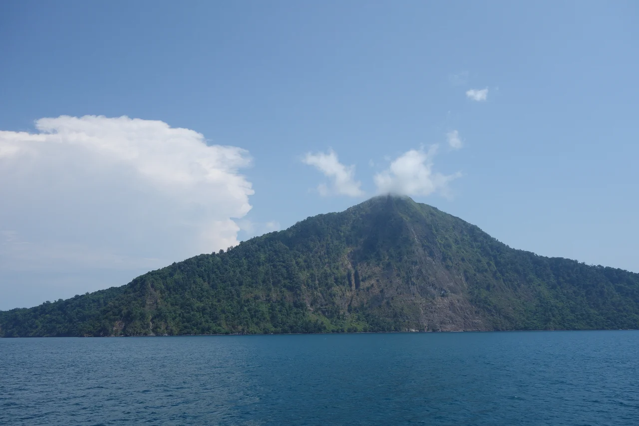
The Survivor's Silhouette
From the air, Rakata's profile is unmistakable. The southern slope rises gently, cloaked in green where tropical forest has reclaimed the mountainside. Then the summit drops away into nothing -- a vertical plunge to the sea where the northern half used to be. The contrast is dramatic and immediate: nature's patient recovery on one side, nature's violent erasure on the other. Rakata stands at the southern edge of the Krakatoa archipelago, with Verlaten and Lang curving around to the northwest and northeast, and the dark, smoking cone of Anak Krakatau occupying the center of the caldera. Together they form the rim of an ancient bowl, a family portrait in volcanic rock. Rakata is the elder, the one that endured. It has not erupted since 1883 -- all subsequent activity has shifted north to Anak Krakatau's domain. The Eye stares out from its cliff, indifferent to the passage of time, while below it the forest thickens and the birds multiply and the strait continues its slow, restless work.
From the Air
Rakata is located at 6.15S, 105.44E in the Sunda Strait, Indonesia, forming the southern anchor of the Krakatoa archipelago. The volcano's distinctive half-profile -- green slopes to the south, sheer cliff to the north -- is visible from cruising altitude. Look for the vertical northern face exposing layered volcanic strata and the Eye of Krakatoa formation at mid-cliff. Nearest airports: Soekarno-Hatta International (WIII) in Jakarta ~150 km northeast, Radin Inten II (WICT) in Lampung ~80 km northwest. Active volcanic area; Anak Krakatau may produce ash plumes nearby. Best viewed from 5,000-10,000 feet on a clear day.
Nearby Stories
- Sunda Strait Bridge 4.5 km away
- When the Earth Swallowed Batavia 21 km away
- Where Tigers Return and Addicts Heal 24 km away
- Ujung Kulon National Park 28 km away
- The Passage Between Giants 53 km away
- The King's Footprints in the River 96 km away
- Surfing in Indonesia 149 km away
- Sainte-Rose, Réunion 5506 km away