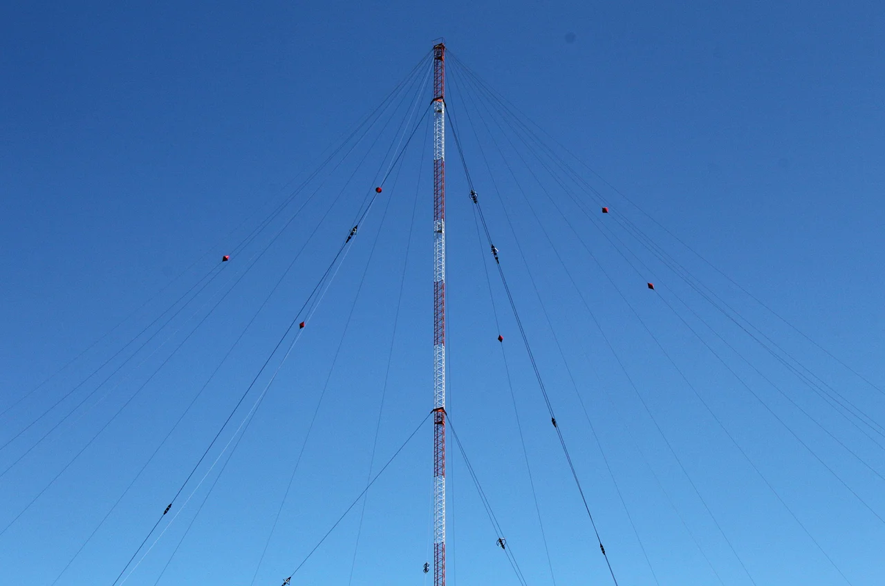
Rantum Loran-C Transmitter
At midnight on the last day of 2015, an engineer on the German island of Sylt threw a switch and a signal that had been pulsing across the North Sea for fifty-two years went silent. The Rantum transmitter, a 193-meter radio mast erected by the United States Coast Guard in 1963, had spent its entire life telling ships and aircraft where they were. By the time it stopped, satellites had been doing the same job, more accurately, for two decades. Loran-C did not so much die as quietly time out.
How a Hyperbola Tells You Where You Are
Loran-C was beautiful applied geometry. A chain of synchronized transmitters fired low-frequency pulses at precisely staggered intervals - measured by something called the group repetition interval - and a receiver on a ship or in an aircraft cockpit measured the tiny difference between the arrival times of pulses from different stations. Each difference defined a hyperbolic line of position on a chart. Two intersecting hyperbolas gave you a fix. The Rantum mast was part of two such chains, identified by their GRIs: Sylt at 7499 and Lessay at 6731. A skipper in the North Sea fog, hand on the receiver dial, could read his position to within a few hundred meters in conditions where dead reckoning would have killed him. The whole system rested on the fact that radio waves travel at a known speed and a clock can be made very, very accurate.
An American Mast on a German Resort
Why an American Coast Guard installation on a German tourist island? Cold War geography. In 1963, when construction began on the dunes south of Rantum, Sylt sat at the edge of NATO's North Sea defenses, looking straight across the water at the Eastern Bloc. American ships, submarines, and aircraft operating in the area needed precise navigation that did not depend on terrain features they might never see. A Loran chain stretching from Norway through Iceland to Sylt to Lessay in northern France traced a hyperbolic grid across the entire approach to the Soviet Arctic. The German government did not own the station and did not operate it until 1989, when the Coast Guard transferred control to the Wasser- und Schifffahrtsamt at Tönning. In 1995, the mast and the responsibility passed entirely into German civilian hands.
Beaten by GPS
By the 1990s, satellite navigation had begun the slow process of making radio chains obsolete. GPS was free, more precise, available everywhere on the surface of the planet and increasingly built into devices the size of a paperback book. The first Loran-C shutdowns came in 2010 in the United States and Canada. In 2014, France and Norway announced they would close their stations - and once those nodes dropped, the European chain became geometrically unusable. England and Germany kept their transmitters running until 31 December 2015, then synchronized one final shutdown across the continent. Norway's stations went dark the same night. The hyperbolic grid that had guided North Sea shipping for half a century vanished in a few hours.
Fire and Aftermath
The station's last decade was not entirely uneventful. In August 2011 a fire broke out at the Sylt Loran-C facility - a serious enough blaze that local newspapers reported on flooded roads and emergency response alongside the smoke. The mast survived. The transmitter, rated at 250 kilowatts, kept pulsing its 100-kHz signal into the cold air of the German Bight. Operators repaired the damage and the chain stayed on the air until its scheduled end four years later. Today the tall steel structure still rises above the Rantum dunes, dark, visible from kilometers in any direction. Plans to repurpose the European Loran chains for what's called eLoran - a backup to GPS for the day satellite navigation fails or is jammed - have been proposed and re-proposed, but no signal has returned to the Rantum antenna.
Geography of a Quiet Mast
Rantum itself is a small dune-bound village on the narrow waist of Sylt, with the open North Sea to the west and the calmer Wadden Sea tidal flats to the east. The mast stands roughly two kilometers south of the village, conspicuous against an otherwise low horizon of dune grass and beach huts. Locals navigate by it the way mainland Germans navigate by a church spire. Bird-watchers visiting the Wadden Sea reserves nearby still use it as a landmark. The signal is gone, but the geometry that built it - tall thin metal against flat horizon - remains the most legible feature of the southern half of the island.
From the Air
The Rantum Loran-C mast sits at 54.81N, 8.29E on the narrow southern half of Sylt, roughly 2 km south of Rantum village. The mast rises 193 meters above relatively flat dune terrain and is visible from extreme range in clear weather; it is the most prominent vertical feature in the southern half of the island. Sylt Airport (EDXW) is 10 km north. Helgoland and the German Bight oil fields lie to the west.
Nearby Stories
- Amrumbank West 26 km away
- German Bight 34 km away
- HMS Ariel (1911) 38 km away
- Tvindkraft Wind Turbine 138 km away
- Lilleø 173 km away
- Clausholm Castle 175 km away
- Wöbbelin Concentration Camp 217 km away
- Battle of Jutland 219 km away