Rio Abiseo National Park
Most national parks want visitors. Rio Abiseo has spent nearly four decades trying to keep them out. Since 1986, the park has been closed to tourism, not because it is dangerous or remote or inaccessible - although it is all of those - but because its archaeological sites and cloud forest ecosystems are too fragile to survive the foot traffic a typical reserve absorbs. If you want to see Gran Pajaten, the stone city at its heart, you will need permits that are almost never granted. For most travelers, Rio Abiseo exists mainly as a line on a map between the Maranon and Huallaga rivers - 2,745 square kilometers of forbidden mountain.
A Park with Rules You Can't Negotiate
Rio Abiseo was established as a Peruvian national park in August 1983. UNESCO added it to the World Heritage list twice - first as a natural site in 1990 and then as a mixed natural and cultural site in 1992, one of the few places on Earth to hold both designations. The park covers 70% of the Abiseo River basin and spans elevations from 350 meters at the lowest to 4,200 meters at the high alpine puna - a range of environments few reserves can match. Tourism closed in 1986 for good reason: the cloud forest on these slopes took thousands of years to build and can be destroyed by a single wet season of trampled mud and introduced seeds. Permits may be obtained through Peru's park service (formerly INRENA, now SERNANP) for legitimate research. Tarapoto hotels can sometimes direct serious applicants to local guides who know the way in.
What the Cloud Forest Holds
The park protects three distinct ecoregions stacked by elevation: Ucayali moist forests at the bottom, Peruvian Yungas at middle elevations, and the Cordillera Central paramo at the highest reaches. In the cloud forest proper - everything above about 2,300 meters - short trees disappear under a pelt of mosses and lichens, and humidity hangs permanently around the treetops. Rain falls through most of the year. Seven climate zones coexist within the park boundaries, from montane rainforest to alpine grassland, and between them they shelter 5,000 plant species in the lower areas and another 980 documented in the highlands, with thirteen endemics. Wildlife includes jaguar, spectacled bear, the Peruvian guemal, three-striped night monkey, and something so rare that the whole park was basically created to save it.
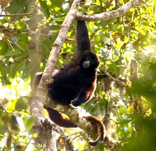
The Monkey That Came Back
The yellow-tailed woolly monkey (Oreonax flavicauda) was thought to be extinct for much of the 20th century. When biologists confirmed it was still alive, in the forests of what is now Rio Abiseo, its critically endangered status drove the park's creation. It remains endemic to this region - found nowhere else on Earth. The monkey is reddish-brown with a distinctive yellow patch on the underside of its tail, and it lives in the middle-elevation cloud forest, eating fruit and flowers. Because of the closure, it has been left largely in peace. That is the park's working compromise: no tourists, a recovering population, and a few researchers who treat every step they take as borrowed from the ecosystem.
Gran Pajaten
Behind the tourism ban is an archaeology story just as delicate. Deep inside the park, atop a forested ridge overlooking the Montecristo River canyon, sits Gran Pajaten - a ruined settlement of circular stone buildings decorated with geometric friezes and stylized human figures, widely attributed to the Chachapoya culture. The site was rediscovered by villagers from Pataz in 1963 and studied most extensively by the University of Colorado during the mid-1980s. Nearby, cliff tombs at Los Pinchudos were found by Pataz villagers in the early 1970s. The park contains more than thirty pre-Columbian archaeological sites in total. Most have never been excavated. The park administration's logic is simple: every footfall on a cloud-forest ruin does damage, and there are more ruins here than researchers to protect them.
Seeing Without Entering
For most travelers, the way to experience Rio Abiseo is to approach it - to fly over it, to stand on a ridge across the valley from it, to understand what is being protected. From the air, the park is a dense, dark green block of cloud forest hanging between two great rivers of the Peruvian Amazon watershed, threaded with cataracts and isolated ridges. That silhouette is what a functioning ecosystem looks like when left alone. Rio Abiseo is the rare protected area that is doing its job exactly because it has said no to us - a slightly unsettling, slightly admirable idea. There are not many parks that have made us prove our interest before opening their gates.
From the Air
Located at 7.75 degrees south, 77.25 degrees west, in Peru's San Martin region between the Maranon and Huallaga rivers. The park spans elevations from around 350 m in the eastern foothills to 4,200 m on the western ridge; terrain is steep cloud forest below and alpine puna above. Visible from altitude as a dense green-black block with frequent cloud cover. Nearest airport of regional significance is Moyobamba (SPMB / MBP) to the north or Tarapoto (SPST / TPP) to the east. Expect rapid orographic buildup; VFR is often poor on the windward eastern slope.
Nearby Stories
- Gran Pajatén 12 km away
- Huamachuco 39 km away
- Pallasca District 39 km away
- Pirca Pirca 58 km away
- Huacrachuco 58 km away
- Inca Civil War 162 km away
- 2005 Northern Peru Earthquake 211 km away
- Huánuco 238 km away